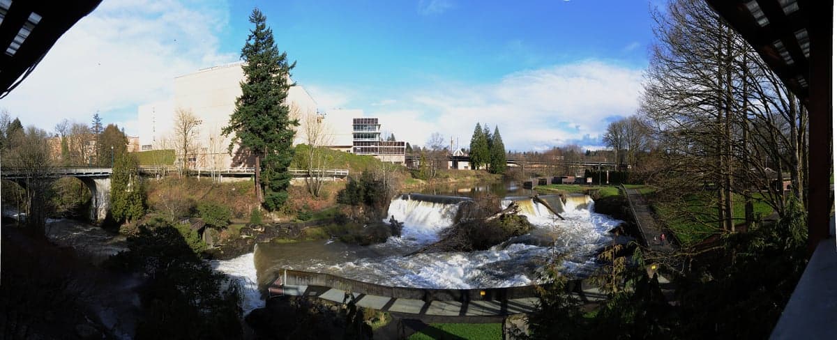
Photo: Wikipedia
Strategic Assessment of Tumwater, WA
Meaningful friction. Expect exposure to either population pressure, blast zones, or natural disaster risk. Consider buying a retreat property.
What does the Strategic Assessment tell us?
Our Strategic Assessment grades tactical survivability of an area. Major population centers, military targets, fallout zones, natural disasters, and border exposure all drive risk — lower exposure means a more defensible position in a crisis.
This is heavily inspired by Joel Skousen's Strategic Relocation book. Highly recommended you checkout the book ($)What does this tell us?
Our Strategic Assessment grades tactical survivability of an area. Major population centers, military targets, fallout zones, natural disasters, and border exposure all drive risk — lower exposure means a more defensible position in a crisis.
This is heavily inspired by Joel Skousen's Strategic Relocation book. Highly recommended you checkout the book ($)Strategic Pillars

Key Distances
Regional Safe Places
Below is our recommended "safe zones" in Washington and the surrounding area based on our strategic heuristics. For most people, it's unrealistic to live in a “safe zone” full-time due to work, family or other personal reasons. They tend to be more rural. However, many of these areas are perfect for second homes and retreat properties that double as a vacation home or even a short-term rental.
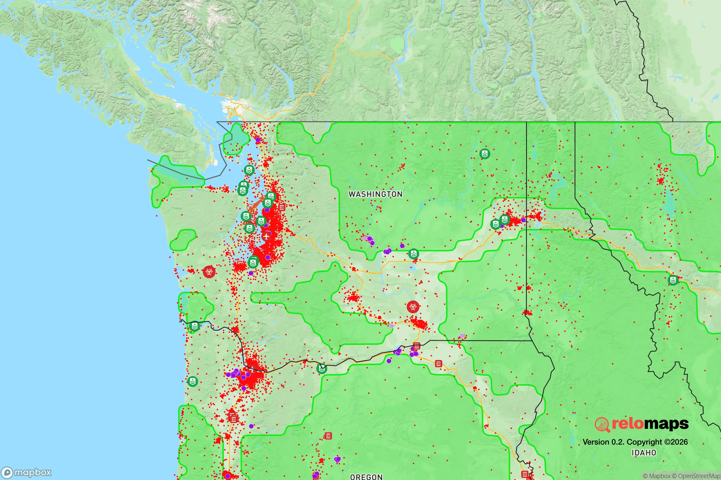
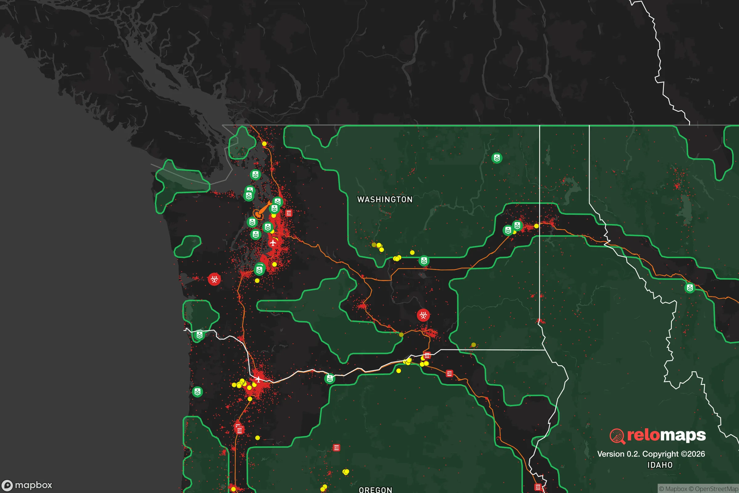


Important Note: For informational purposes only. This does not mean nothing bad ever happens in the green zones. Please use common sense. This is based on public data and modeled with AI. We tried to take a conservative approach but mistakes happen. We update this regularly as new information becomes available.
Solar Generator Recommendations
Backup power matters more here than in safer locations. We've picked three solar generators across budgets and capacity tiers — start with the budget unit if you only need a few essentials, or step up if you want to run a fridge and HVAC for days at a time.

Jackery Portable Power Station Explorer 300
Budget OptionPower on the Go: Weighing only 11 lbs, it's convenient to set up and store with book-sized foldable solar panels

BLUETTI Portable Power Station AC180
Designed for both indoor and outdoor scenarios, AC180 is highly capable as it has a robost capacity and continuous output power.

EF ECOFLOW DELTA Pro Ultra Power Station
Upgraded PickEcoFlow DELTA Pro Ultra is a whole-home energy system designed to grow with your family. Integrated with the Smart Home Panel 2, it scales to meet your evolving energy needs — keeping your home powered, intelligent, and secure through every stage of life.
We earn a commission, at no additional cost to you.
Strategic Assessment Analysis
Tumwater, Washington, occupies a strategic position at the southern tip of Puget Sound, where the Deschutes River meets the Capitol Lake basin, offering a blend of natural defensibility and access to critical infrastructure that appeals to relocation-minded individuals and families with a conservative, self-reliance bent. Its location just south of Olympia and roughly 60 miles from Seattle places it within a major metropolitan corridor, yet its geography—nestled against the Black Hills and the Deschutes Valley—provides a degree of separation from the densest urban zones. For a reader assessing resilience, Tumwater’s advantages hinge on its water resources, moderate climate, and relative insulation from coastal storm surges, but its proximity to state government hubs, military installations, and transportation chokepoints introduces vulnerabilities that demand careful consideration.
Geographic position and natural advantages for long-term stability
Tumwater sits at the confluence of the Deschutes River and the southernmost reach of Puget Sound, giving it direct access to abundant freshwater from the Deschutes watershed, which flows from the Cascade foothills. The city’s elevation ranges from roughly 50 to 200 feet above sea level, placing most developed areas well above tsunami inundation zones that threaten coastal communities like Aberdeen or Ocean Shores. The surrounding Black Hills and Capitol State Forest provide a natural buffer to the west, while the Olympic Mountains and Cascade Range offer distant protection from Pacific storms. The region’s temperate marine climate—with average annual rainfall around 50 inches, mild winters rarely below freezing, and summer highs in the low 80s—supports year-round agriculture and reduces the risk of extreme weather events like tornadoes or prolonged heatwaves. For a relocator prioritizing self-sufficiency, the area’s long growing season (roughly 180 frost-free days) and fertile glacial soils make small-scale farming or gardening viable, especially in the rural pockets south and east of the city limits. Tumwater’s position also places it within a 30-minute drive of the Puget Sound coastline, offering potential maritime resources, though the lack of a deep-water port in the immediate vicinity limits large-scale shipping access.
Risks, exposures, and proximity to fallout-relevant landmarks
Tumwater’s greatest strategic weakness is its proximity to high-value government and military targets in the Puget Sound region. Olympia, the state capital, lies directly north, with the Washington State Capitol Campus and associated government offices concentrated just 5 miles away. Joint Base Lewis-McChord (JBLM), a major Army and Air Force installation, is roughly 25 miles northeast, housing over 40,000 active-duty personnel and serving as a key deployment hub for the Pacific theater. In a conflict scenario involving nuclear or conventional strikes, these assets would be primary targets, and Tumwater’s location within the blast and fallout zones of a ground burst at JBLM or a high-altitude detonation over Olympia would pose existential risks. The city also sits within the inundation zone of the Alder Dam on the Nisqually River, roughly 40 miles upstream; a catastrophic dam failure—whether from seismic activity or sabotage—could send a wall of water down the Nisqually Valley, though Tumwater’s elevation and distance from the river’s main channel reduce the direct threat compared to downstream communities like Roy or McKenna. Seismic risk is moderate: the Cascadia subduction zone, capable of a magnitude 9.0 earthquake, lies 100 miles offshore, and the area experiences frequent smaller quakes from the Juan de Fuca plate. A major Cascadia event would likely cause widespread liquefaction in low-lying areas near the Deschutes River and Capitol Lake, damaging roads, bridges, and utilities. Additionally, the I-5 corridor, which runs directly through Tumwater, is a critical transportation artery that would become a chokepoint during any evacuation or supply disruption, potentially trapping residents in gridlock.
Practical resilience for a relocator: food, water, energy, and defensibility
For a family or individual serious about self-sufficiency, Tumwater offers a mixed picture. Water access is a clear strength: the Deschutes River and numerous smaller creeks provide surface water for filtration or diversion, and the city’s groundwater aquifer is generally reliable, though municipal supplies depend on the Olympia-Tumwater Water System, which could be compromised during a prolonged power outage or contamination event. Private wells are common in the rural areas south of town, and drilling depths typically range from 100 to 300 feet, with yields sufficient for household use and small-scale irrigation. Food resilience is moderate: the surrounding Thurston County has a robust agricultural sector, with over 1,200 farms producing berries, vegetables, dairy, and livestock within a 20-mile radius, but most of this output flows through commercial supply chains rather than local direct-to-consumer networks. Farmers’ markets in Tumwater and Olympia operate seasonally, and the region’s mild climate allows for year-round vegetable production in hoop houses or cold frames. Energy infrastructure is a vulnerability: the local grid is served by Puget Sound Energy, which relies heavily on hydroelectric power from the Columbia and Snake rivers, plus natural gas and some coal. A Cascadia earthquake or cyberattack could disrupt transmission lines, and solar potential is limited by frequent cloud cover (roughly 150 sunny days per year), though micro-hydro from the Deschutes River or small wind turbines on elevated properties could supplement. Defensibility is a challenge: Tumwater’s suburban layout, with cul-de-sacs and arterial roads, offers some natural chokepoints, but the city’s population density (roughly 2,500 people per square mile) and proximity to Olympia mean that a collapse in civil order would likely lead to pressure from urban refugees moving south along I-5. The Black Hills to the west provide a potential retreat area, but public land access is restricted, and private parcels with defensible terrain are expensive, with median home prices exceeding $500,000 as of 2025.
Overall, Tumwater presents a calculated trade-off for the resilience-minded relocator. Its water resources, mild climate, and agricultural hinterland offer genuine advantages for long-term self-sufficiency, but its position within the Puget Sound megaregion—within striking distance of state government, a major military base, and a critical transportation corridor—introduces risks that are hard to mitigate without significant land ownership, off-grid infrastructure, and a solid community network. For a family willing to invest in a rural property south of the city, drill a well, install solar with battery backup, and stockpile supplies, Tumwater could serve as a viable base of operations. But for those seeking true isolation from national-level threats, the area’s strategic liabilities likely outweigh its natural blessings. The prudent approach is to treat Tumwater as a semi-permeable redoubt: close enough to urban resources for trade and information, but with a clear exit plan to the Olympic Peninsula or eastern Washington if the situation deteriorates.

* Values derived from national, state, county, city and local statistics and may differ in a specific area. Last updated: 2026-10-11T16:28:51.000Z
Narrative content on this page is AI-generated and may contain mistakes. Verify any details that matter before acting on them.
ReloMaps may earn a commission from affiliate links at no extra cost to you.

