Photo: Wikipedia
Strategic Assessment of North Fork, CA
Workable tactical position. Some exposure to population density or targets, but generally defensible in a crisis.
What does the Strategic Assessment tell us?
Our Strategic Assessment grades tactical survivability of an area. Major population centers, military targets, fallout zones, natural disasters, and border exposure all drive risk — lower exposure means a more defensible position in a crisis.
This is heavily inspired by Joel Skousen's Strategic Relocation book. Highly recommended you checkout the book ($)What does this tell us?
Our Strategic Assessment grades tactical survivability of an area. Major population centers, military targets, fallout zones, natural disasters, and border exposure all drive risk — lower exposure means a more defensible position in a crisis.
This is heavily inspired by Joel Skousen's Strategic Relocation book. Highly recommended you checkout the book ($)Strategic Pillars

Key Distances
Regional Safe Places
Below is our recommended "safe zones" in California and the surrounding area based on our strategic heuristics. For most people, it's unrealistic to live in a “safe zone” full-time due to work, family or other personal reasons. They tend to be more rural. However, many of these areas are perfect for second homes and retreat properties that double as a vacation home or even a short-term rental.

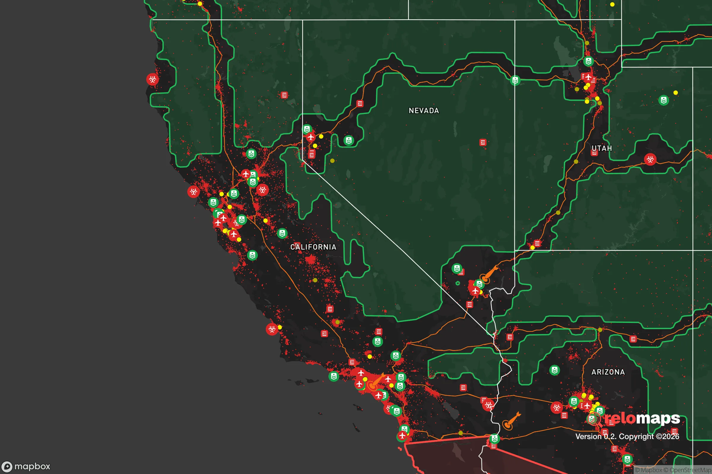


Important Note: For informational purposes only. This does not mean nothing bad ever happens in the green zones. Please use common sense. This is based on public data and modeled with AI. We tried to take a conservative approach but mistakes happen. We update this regularly as new information becomes available.
Solar Generator Recommendations
Backup power matters more here than in safer locations. We've picked three solar generators across budgets and capacity tiers — start with the budget unit if you only need a few essentials, or step up if you want to run a fridge and HVAC for days at a time.

Jackery Portable Power Station Explorer 300
Budget OptionPower on the Go: Weighing only 11 lbs, it's convenient to set up and store with book-sized foldable solar panels

BLUETTI Portable Power Station AC180
Designed for both indoor and outdoor scenarios, AC180 is highly capable as it has a robost capacity and continuous output power.

EF ECOFLOW DELTA Pro Ultra Power Station
Upgraded PickEcoFlow DELTA Pro Ultra is a whole-home energy system designed to grow with your family. Integrated with the Smart Home Panel 2, it scales to meet your evolving energy needs — keeping your home powered, intelligent, and secure through every stage of life.
We earn a commission, at no additional cost to you.
Strategic Assessment Analysis
North Fork, California, sits in a sweet spot that few people fully appreciate until they look at a map: it’s close enough to the Sierra Nevada’s resources to matter, but far enough from the Central Valley’s sprawl and the coast’s population centers to offer genuine strategic depth. For someone thinking about disaster readiness and self-sufficiency, this small Madera County community—roughly 45 minutes northeast of Fresno—offers a mix of mountain access, agricultural proximity, and relative isolation that’s hard to beat at its price point. The trade-offs are real, though, and they center on wildfire risk, a single-road dependency, and the fact that you’re still within a day’s drive of some very large targets.
Geographic position and natural advantages for long-term resilience
North Fork’s core advantage is its position at the western edge of the Sierra Nevada foothills, where the San Joaquin Valley meets the mountains. That puts you at roughly 2,600 feet elevation—high enough to escape the valley’s summer heat and winter fog, but low enough that snow isn’t a persistent problem. The surrounding Sierra National Forest provides a buffer of public land that limits dense suburban encroachment, and the San Joaquin River runs through the region, with several tributaries and creeks feeding the area’s watershed. For a relocator, that means water is more available than in the valley floor, though it’s not unlimited.
The terrain itself is defensible in a practical sense. North Fork sits in a valley pocket with ridges on multiple sides, which limits approach routes and gives residents natural chokepoints. The community is spread out rather than concentrated, which reduces the chaos factor during a regional emergency. You’re also within striking distance of the high Sierra—Yosemite’s southern entrance is about an hour away—which offers a wilderness retreat option if things go sideways. The downside of that geography is that the primary access route, Road 274 (also known as the North Fork Road), is a winding two-lane mountain road that can be blocked by slides, snow, or fire. There are secondary routes, but they’re not all-weather, and that’s a vulnerability you need to plan around.
Risk profile: wildfire, seismic activity, and proximity to high-value targets
Wildfire is the dominant natural risk in North Fork, and it’s not hypothetical. The 2020 Creek Fire burned over 379,000 acres in the Sierra National Forest, and the community was under evacuation orders for weeks. The surrounding vegetation—dense pine, oak, and manzanita—is fire-adapted and will burn again. Homes in the area are increasingly required to maintain defensible space, and insurance costs have risen sharply in recent years, with some carriers pulling out of high-risk zones entirely. If you’re serious about resilience here, fire hardening is not optional; it’s the price of admission.
Seismic risk is moderate. The Sierra Nevada fault system runs along the eastern edge of the range, and the region experiences occasional swarms of small earthquakes. A major event on the eastern Sierra faults could disrupt roads and power lines, but the more significant seismic threat comes from the San Joaquin Valley’s subsidence issues, which are more of a slow-motion problem than an acute one. The bigger man-made risk is proximity to the Central Valley’s critical infrastructure. Fresno, about 40 miles southwest, is a major agricultural hub with rail lines, highways, and a large population—roughly 550,000 in the city proper. In a major conflict or grid-down scenario, that makes the valley a plausible target for disruption, and North Fork’s mountain roads could become congested with evacuees heading your direction. You’re not in a blast zone, but you’re in the evacuation shadow of one, and that’s a factor worth planning for.
Practical resilience: food, water, energy, and defensibility for a relocator
Food security in North Fork is genuinely workable. The community sits at the edge of Madera County’s agricultural belt, and local farms, orchards, and ranches produce a meaningful share of what the region consumes. The North Fork Farmers Market and nearby roadside stands provide seasonal produce, and the area’s hunting and fishing opportunities—deer, turkey, and trout in the San Joaquin and its tributaries—add a protein source that’s not available in most suburban settings. For a family looking to garden, the growing season is shorter than the valley’s but longer than the high Sierra’s, and the soil, while rocky in places, is workable with raised beds and compost. The key limitation is storage: you’ll want a solid pantry and a plan for canning or dehydrating, because winter access to fresh supplies can be intermittent.
Water is the area’s strongest practical asset. The San Joaquin River and its tributaries—including Willow Creek and Fine Gold Creek—provide surface water, and many properties in the area have wells that tap into the Sierra’s fractured granite aquifers. Well depth varies significantly, so a new buyer should get a well report before committing, but the water table here is generally more reliable than in the valley, where overdraft is a chronic issue. That said, surface water requires treatment, and a gravity-fed or solar-pumped system is a worthwhile investment. Power is less certain. PG&E serves the area, and public safety power shutoffs (PSPS events) have become routine during high-wind fire conditions, sometimes lasting days. Solar with battery storage is increasingly common, and the area’s sunny summers make it viable, but winter cloud cover and snow can reduce output for weeks at a time. A backup generator, preferably dual-fuel, is a practical addition.
Defensibility is a mixed picture. The community’s dispersed layout and natural ridgelines work in your favor, but the single primary road is a liability. In a fire evacuation, the North Fork Road can become a bottleneck, and in a grid-down scenario, it’s a target for anyone looking to leave the valley. The local culture is self-reliant—this is a working-class mountain community with a strong hunting and outdoor tradition—and neighbors tend to know each other, which matters in a crisis. The Madera County Sheriff’s Office has a substation in town, and the North Fork Volunteer Fire Department provides local response, but both are stretched thin in a regional event. The practical takeaway is that you can build a defensible property here, but you can’t defend the approach road alone; community coordination is part of the plan.
The strategic picture for a serious relocator
North Fork offers a rare combination of mountain resources, agricultural access, and genuine isolation from the state’s major population centers, all at a cost of living that remains below California’s coastal averages. The risks are real—wildfire is the headline, and the single-road dependency is a structural weakness—but they’re manageable with preparation. For a single individual or family willing to invest in fire hardening, water storage, and off-grid power, this is one of the more viable self-sufficiency locations in the central Sierra foothills. It’s not a bug-out destination; it’s a live-in resilience play, and that’s a different and arguably stronger commitment. If you’re looking for a place where you can build a life that doesn’t collapse when the grid does, North Fork deserves a serious look.

* Values derived from national, state, county, city and local statistics and may differ in a specific area. Last updated: 2026-10-21T10:02:19.000Z
Narrative content on this page is AI-generated and may contain mistakes. Verify any details that matter before acting on them.
ReloMaps may earn a commission from affiliate links at no extra cost to you.

