
Photo: Wikipedia
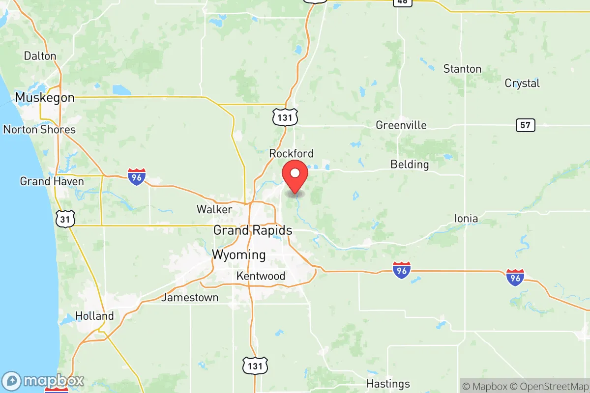
Strategic Assessment of Kent County
Meaningful friction. Expect exposure to either population pressure, blast zones, or natural disaster risk. Consider buying a retreat property.
What does the Strategic Assessment tell us?
Our Strategic Assessment grades tactical survivability of an area. Major population centers, military targets, fallout zones, natural disasters, and border exposure all drive risk — lower exposure means a more defensible position in a crisis.
This is heavily inspired by Joel Skousen's Strategic Relocation book. Highly recommended you checkout the book ($)What does this tell us?
Our Strategic Assessment grades tactical survivability of an area. Major population centers, military targets, fallout zones, natural disasters, and border exposure all drive risk — lower exposure means a more defensible position in a crisis.
This is heavily inspired by Joel Skousen's Strategic Relocation book. Highly recommended you checkout the book ($)Strategic Pillars

Key Distances
Strategic Assessment Analysis
Kent County, Michigan, offers a strategic blend of Midwestern stability and Great Lakes access that makes it a serious contender for those prioritizing long-term resilience over coastal vulnerability. Anchored by Grand Rapids, the county sits far enough from major fallout corridors like Chicago or Detroit to avoid the worst of a cascading collapse, yet close enough to leverage regional supply chains and medical infrastructure. The area’s diversified economy—rooted in manufacturing, healthcare, and agriculture—provides a buffer against single-sector shocks, while the presence of Gerald R. Ford International Airport and I-96 ensures evacuation or resupply routes remain viable when lesser roads clog. For a relocator weighing civic unrest or disaster scenarios, Kent County’s combination of inland positioning, freshwater abundance, and a politically moderate-to-conservative population base offers a rare sweet spot: insulated but not isolated.
Geographic position and natural advantages for long-term survival
Kent County’s real ace is its location on the eastern shore of Lake Michigan, giving residents direct access to the largest freshwater system in the world—a non-negotiable asset when municipal water treatment fails. The Grand River runs through the heart of the county, cutting from the city of Grand Rapids west to Lake Michigan at Grand Haven, providing a secondary water source and a natural corridor for movement or trade. The terrain is mostly flat to gently rolling, with dense hardwood forests in the northern and eastern townships like Cedar Springs and Rockford, offering both cover and timber for construction or fuel. Winters are harsh—average snowfall exceeds 70 inches in some inland spots—but that same climate deters mass migration from warmer regions during a crisis and naturally preserves stored food and medicine. The county’s position roughly 150 miles from Detroit and 180 miles from Chicago means fallout from a major urban nuclear event would likely dissipate before reaching lethal levels, especially with prevailing westerly winds pushing contamination eastward. For a prepper, this is the kind of buffer that turns a bad day into a manageable week.
Risks, exposures, and proximity to fallout-relevant landmarks
No location is without vulnerabilities, and Kent County has a few that demand attention. The most obvious is the Fermi 2 nuclear power plant in Newport, about 120 miles southeast—close enough that a catastrophic release under certain wind patterns could dust the county’s southern edge. More immediate is the Muskegon County wastewater treatment plant and the Grand Rapids water filtration plant, both of which are single-point-of-failure targets for sabotage or cyberattack. The county also hosts a significant industrial base: the Wyoming refinery (a Marathon Petroleum facility) and numerous chemical storage sites along the Grand River, any of which could become a secondary hazard during civil unrest or a natural disaster. On the security front, the nearest major military installation is Camp Grayling (about 120 miles north), but the Michigan Army National Guard’s 63rd Brigade is headquartered in Grand Rapids, meaning the area would see rapid militarization during a federal emergency—a double-edged sword for those seeking low-profile living. The city of Grand Rapids itself, with a metro population over 1 million, is a concentration risk: a pandemic, food riot, or grid failure would hit hardest in the urban core, so relocators should target exurban towns like Lowell or Sparta to maintain a buffer.
Practical resilience for a relocator: food, water, energy, and defensibility
For the individual or family looking to hunker down, Kent County’s practical infrastructure is encouraging. The region sits atop the Marshall Aquifer, a deep groundwater source that many rural wells tap into at depths of 100-300 feet—far below surface contamination. Surface water from the Grand River and its tributaries (the Rogue, Flat, and Thornapple rivers) is plentiful but requires filtration; a Berkey or similar system is non-negotiable. Food resilience is strong: Kent County is the top agricultural producer in Michigan by market value, with thousands of acres of corn, soybeans, and orchards in the eastern townships. The Grand Rapids Downtown Market and numerous farm-to-table networks exist now, but in a collapse scenario, the real value lies in the Amish and Mennonite communities around Middleville and Wayland—they maintain seed stocks, animal husbandry, and off-grid skills that could be bartered for security or labor. Energy-wise, the county’s grid is fed by natural gas and coal plants, but solar potential is decent (4.5 peak sun hours per day), and wood heating is viable given the forest cover. Defensibility varies by terrain: the flat farmlands south of Grand Rapids offer little cover, but the moraine hills and river valleys north of Rockford create natural chokepoints and observation points. A well-chosen property with a creek, a well, and a view of approach roads can be made quite secure with modest earthworks and a good fence.
The overall strategic picture for Kent County is one of calculated trade-offs. It lacks the extreme isolation of the Upper Peninsula or the deep bunker potential of the Rocky Mountains, but it compensates with immediate access to fresh water, arable land, and a population that is largely self-reliant and culturally aligned with conservative values of preparedness and community. The risks—proximity to a nuclear plant, industrial targets, and a major city—are real but manageable with proper siting and a 72-hour bug-out plan. For the relocator who wants to be close enough to resources to thrive but far enough from the blast zones to survive, Kent County deserves a hard look. Just don’t buy in Grand Rapids proper; aim for the townships where the well water is deep and the neighbors mind their own business.
* Values derived from national, state, county, city and local statistics and may differ in a specific area. Last updated: 2026-05-16T04:01:29.000Z
Narrative content on this page is AI-generated and may contain mistakes. Verify any details that matter before acting on them.
ReloMaps may earn a commission from affiliate links at no extra cost to you.