
Photo: Wikipedia
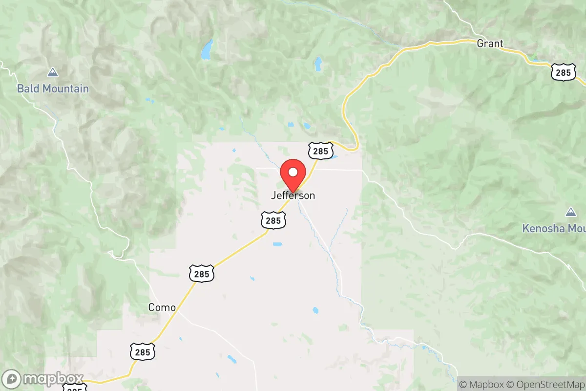
Strategic Assessment of Jefferson, CO
Strong survivability profile. Good buffer from population centers, with manageable environmental and tactical risks.
What does the Strategic Assessment tell us?
Our Strategic Assessment grades tactical survivability of an area. Major population centers, military targets, fallout zones, natural disasters, and border exposure all drive risk — lower exposure means a more defensible position in a crisis.
This is heavily inspired by Joel Skousen's Strategic Relocation book. Highly recommended you checkout the book ($)What does this tell us?
Our Strategic Assessment grades tactical survivability of an area. Major population centers, military targets, fallout zones, natural disasters, and border exposure all drive risk — lower exposure means a more defensible position in a crisis.
This is heavily inspired by Joel Skousen's Strategic Relocation book. Highly recommended you checkout the book ($)Strategic Pillars

Key Distances
Regional Safe Places
Below is our recommended "safe zones" in Colorado and the surrounding area based on our strategic heuristics. For most people, it's unrealistic to live in a “safe zone” full-time due to work, family or other personal reasons. They tend to be more rural. However, many of these areas are perfect for second homes and retreat properties that double as a vacation home or even a short-term rental.


Important Note: For informational purposes only. This does not mean nothing bad ever happens in the green zones. Please use common sense. This is based on public data and modeled with AI. We tried to take a conservative approach but mistakes happen. We update this regularly as new information becomes available.
Solar Generator Recommendations
Backup power matters more here than in safer locations. We've picked three solar generators across budgets and capacity tiers — start with the budget unit if you only need a few essentials, or step up if you want to run a fridge and HVAC for days at a time.

Jackery Portable Power Station Explorer 300
Budget OptionPower on the Go: Weighing only 11 lbs, it's convenient to set up and store with book-sized foldable solar panels

BLUETTI Portable Power Station AC180
Designed for both indoor and outdoor scenarios, AC180 is highly capable as it has a robost capacity and continuous output power.

EF ECOFLOW DELTA Pro Ultra Power Station
Upgraded PickEcoFlow DELTA Pro Ultra is a whole-home energy system designed to grow with your family. Integrated with the Smart Home Panel 2, it scales to meet your evolving energy needs — keeping your home powered, intelligent, and secure through every stage of life.
We earn a commission, at no additional cost to you.
Strategic Assessment Analysis
Jefferson, Colorado, sits in a position that offers genuine strategic depth for those thinking seriously about long-term resilience. Tucked into the foothills of the Front Range, roughly 40 miles southwest of Denver, this unincorporated community in Park County provides a rare combination of mountain seclusion and practical access to supply routes. For a relocator with a prepper mindset—concerned about civic unrest, supply chain disruptions, or larger-scale disasters—Jefferson’s geography is a starting point that demands a hard look at both its advantages and its vulnerabilities. The area’s elevation, around 9,600 feet, and its position off major interstate corridors mean it’s not a natural target for mass evacuation or looting, but it also means winter isolation and limited infrastructure are real factors to plan for.
Geographic position and natural advantages for long-term security
Jefferson’s location is defined by its distance from the Denver metro area’s immediate chaos while still being within a day’s drive of critical resources. The community sits along U.S. Highway 285, a two-lane route that connects to Fairplay (about 15 miles south) and eventually to Buena Vista and the Arkansas River Valley. This road is a double-edged sword: it’s the primary lifeline for supplies, but it’s also a choke point that could be blocked by a single accident or snowstorm. The surrounding Pike National Forest and the vast San Isabel National Forest to the west create a natural buffer zone—hundreds of thousands of acres of rugged terrain that make large-scale movement difficult for anyone without local knowledge. For a survivalist, this means fewer eyes on your property and a lower probability of random foot traffic during a crisis. The area’s water resources are a standout: the South Platte River headwaters and numerous alpine streams run through the region, offering reliable surface water even in dry years, provided you have the means to filter and store it. The high elevation also means cooler summers and heavy snowpack, which acts as a natural water reservoir into late spring—a critical advantage if municipal systems fail.
Risks, exposures, and proximity to fallout-relevant landmarks
No strategic assessment is honest without addressing the downsides, and Jefferson has several that a relocator must weigh. The most glaring is its proximity to Denver and Colorado Springs—both are within 60–80 miles, and both are high-probability targets for civil unrest, terrorist attacks, or infrastructure sabotage. Denver’s population of over 700,000, combined with its role as a regional transportation and government hub, makes it a likely flashpoint. In a scenario involving mass casualty events or a breakdown of order, the exodus from the Front Range would funnel directly up U.S. 285 and I-70, putting Jefferson in the path of desperate people. The area also sits near the Cheyenne Mountain Complex (about 70 miles south), a NORAD facility that, while hardened, could become a target for precision strikes or secondary effects in a major conflict. Additionally, the nearby Rocky Flats National Wildlife Refuge, a former nuclear weapons plant, is roughly 50 miles northeast—though cleaned up, its historical contamination raises questions about long-term environmental risks. For a prepper, these are not deal-breakers but factors that demand a layered defense plan: secure perimeter, cached supplies, and a network of trusted neighbors who can provide early warning.
Practical resilience for a relocator: food, water, energy, and defensibility
For a single individual or a family looking to establish a self-sufficient foothold, Jefferson’s practical resilience is a mixed bag that requires upfront investment. Water is the strongest card: the area’s snowmelt-fed creeks and the nearby Tarryall Creek offer year-round flow, but you’ll need a robust filtration system (think Berkey or a UV unit) because surface water in high-altitude areas can carry giardia and other pathogens. Well drilling is possible but expensive—expect $30,000–$50,000 for a deep well, and permits in Park County are strict. Food production is limited by the short growing season (roughly 60–80 frost-free days) and thin, rocky soil. Raised beds with imported soil and a greenhouse are essential for any serious gardening; otherwise, you’re relying on stored dry goods and hunting. Elk and mule deer are abundant in the national forests, but hunting pressure is high during season, and you’ll need to be proficient with a rifle. Energy is a bright spot: solar potential is excellent at this elevation, with clear skies most of the year. A 5–10 kW off-grid solar setup with battery storage (like lithium iron phosphate) can cover basic needs, but winter cloud cover and snow accumulation on panels require a backup generator or a small wind turbine. Defensibility is where Jefferson shines—the terrain is steep and forested, with limited road access. A property with a single driveway and good sightlines can be secured with minimal effort. However, the lack of a local police presence (Park County Sheriff’s Office covers a vast area with limited deputies) means you are the first line of defense. Building a community of like-minded neighbors is not optional; it’s the difference between a viable retreat and a lonely outpost.
The overall strategic picture for Jefferson is one of high potential paired with significant logistical hurdles. For a relocator with a conservative, self-reliant mindset, this area offers the kind of isolation that allows you to control your own destiny—provided you arrive with a clear plan for water, food, and security. The proximity to Denver is a liability that cannot be ignored, but it’s also a source of supply runs and medical access in normal times. The key is to treat Jefferson as a base for a long-term strategy, not a quick escape hatch. If you’re willing to invest in infrastructure, build local relationships, and accept the harsh winters, this corner of Park County can be a solid anchor in an uncertain future. If you’re looking for a turnkey solution, look elsewhere—Jefferson demands work, but it rewards those who do it.
* Values derived from national, state, county, city and local statistics and may differ in a specific area. Last updated: 2026-05-28T15:55:53.000Z
Narrative content on this page is AI-generated and may contain mistakes. Verify any details that matter before acting on them.
ReloMaps may earn a commission from affiliate links at no extra cost to you.