Photo: Wikipedia
Strategic Assessment of Tamarac, FL
Meaningful friction. Expect exposure to either population pressure, blast zones, or natural disaster risk. Consider buying a retreat property.
What does the Strategic Assessment tell us?
Our Strategic Assessment grades tactical survivability of an area. Major population centers, military targets, fallout zones, natural disasters, and border exposure all drive risk — lower exposure means a more defensible position in a crisis.
This is heavily inspired by Joel Skousen's Strategic Relocation book. Highly recommended you checkout the book ($)What does this tell us?
Our Strategic Assessment grades tactical survivability of an area. Major population centers, military targets, fallout zones, natural disasters, and border exposure all drive risk — lower exposure means a more defensible position in a crisis.
This is heavily inspired by Joel Skousen's Strategic Relocation book. Highly recommended you checkout the book ($)Strategic Pillars

Key Distances
Regional Safe Places
Below is our recommended "safe zones" in Florida and the surrounding area based on our strategic heuristics. For most people, it's unrealistic to live in a “safe zone” full-time due to work, family or other personal reasons. They tend to be more rural. However, many of these areas are perfect for second homes and retreat properties that double as a vacation home or even a short-term rental.

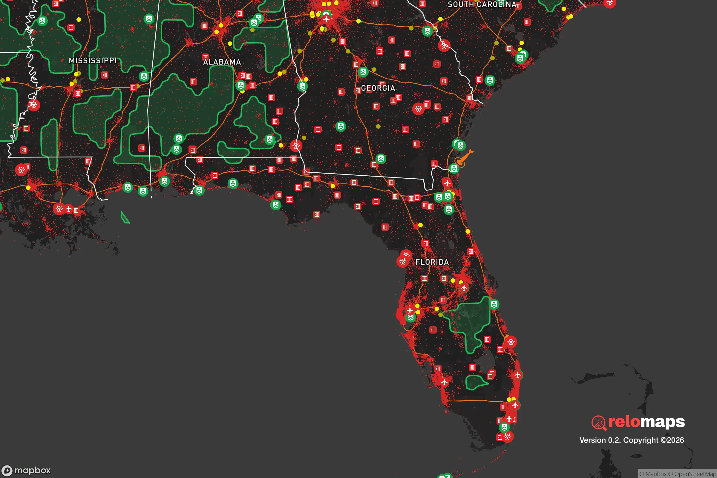
Important Note: For informational purposes only. This does not mean nothing bad ever happens in the green zones. Please use common sense. This is based on public data and modeled with AI. We tried to take a conservative approach but mistakes happen. We update this regularly as new information becomes available.
Solar Generator Recommendations
Backup power matters more here than in safer locations. We've picked three solar generators across budgets and capacity tiers — start with the budget unit if you only need a few essentials, or step up if you want to run a fridge and HVAC for days at a time.

Jackery Portable Power Station Explorer 300
Budget OptionPower on the Go: Weighing only 11 lbs, it's convenient to set up and store with book-sized foldable solar panels

BLUETTI Portable Power Station AC180
Designed for both indoor and outdoor scenarios, AC180 is highly capable as it has a robost capacity and continuous output power.

EF ECOFLOW DELTA Pro Ultra Power Station
Upgraded PickEcoFlow DELTA Pro Ultra is a whole-home energy system designed to grow with your family. Integrated with the Smart Home Panel 2, it scales to meet your evolving energy needs — keeping your home powered, intelligent, and secure through every stage of life.
We earn a commission, at no additional cost to you.
Strategic Assessment Analysis
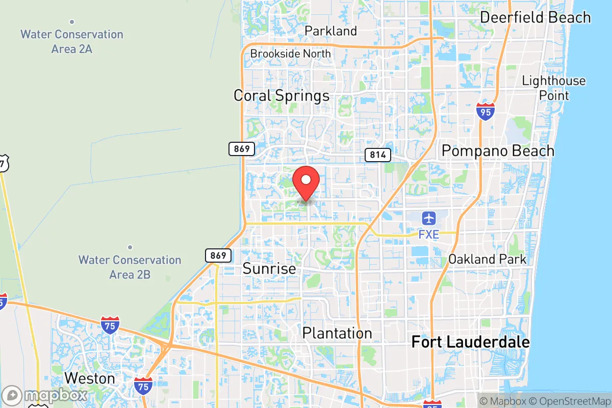
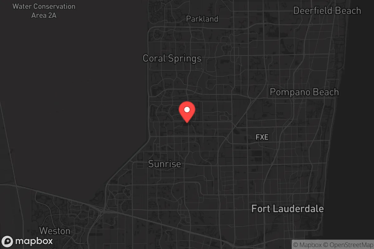
Tamarac, Florida, sits in a precarious strategic position that demands serious scrutiny from anyone prioritizing long-term resilience and self-sufficiency. While its location in central Broward County offers immediate access to major infrastructure and employment corridors, the same factors that make it convenient for daily life create significant vulnerabilities for those planning for civic unrest, mass casualty events, or large-scale disasters. The city's flat, suburban layout, dense population, and proximity to both the Atlantic coast and major urban centers like Fort Lauderdale and Miami mean that any relocator must weigh the benefits of established services against the very real risks of being trapped in a high-density, low-defensibility environment when things go sideways.
Geographic position and natural advantages for long-term survival
Tamarac's geographic reality is defined by its position roughly 10 miles inland from the Atlantic Ocean, placing it in the middle of the South Florida sprawl. The city sits on a flat coastal plain with an average elevation of just 9 feet above sea level, which offers no natural high ground or defensible terrain. On the positive side, the area benefits from the Biscayne Aquifer, a massive underground freshwater source that provides reliable drinking water to most of Broward County—a critical advantage if municipal systems are compromised. The subtropical climate allows for year-round growing seasons, meaning determined residents can cultivate food crops even in winter months, though the sandy, nutrient-poor soil requires significant amendment. The extensive canal system, originally built for drainage, provides potential secondary water sources and limited transportation routes away from main roads, though these canals also create choke points and flood risks during hurricane events. For a relocator, the natural advantages here are minimal: flat terrain offers no defensive positions, the coastline is a major evacuation bottleneck, and the entire region is vulnerable to storm surge from even moderate hurricanes.
Risks, exposures, and proximity to fallout-relevant landmarks
The most glaring strategic weakness of Tamarac is its proximity to multiple high-value targets and population centers that would become chaotic during any major crisis. The city lies within 15 miles of Fort Lauderdale-Hollywood International Airport, Port Everglades (one of the busiest cargo and cruise ports in the country), and the I-95 corridor—all likely evacuation routes and potential targets for civil unrest or infrastructure attacks. Miami is roughly 30 miles south, and the entire tri-county area (Miami-Dade, Broward, Palm Beach) holds over 6 million people, meaning any regional disaster would trigger massive, gridlocked evacuation attempts. Tamarac itself has a population density of over 4,500 people per square mile, making it one of the more densely populated suburbs in Broward. During a mass casualty event or widespread civil unrest, the city's reliance on a few major arterial roads (University Drive, Commercial Boulevard, and McNab Road) would create instant bottlenecks. The nearby Everglades to the west offer some escape route potential, but they are swampy, mosquito-infested, and largely impassable without specialized equipment. For a prepper mindset, Tamarac's location is a liability: too close to major targets, too dense to defend, and too flat to hide.
Practical resilience for a relocator: food, water, energy, and defensibility
When assessing Tamarac's practical resilience for a single individual or family, the picture is mixed but leans negative. Water is the strongest point: the Biscayne Aquifer provides abundant, shallow groundwater that can be accessed with a simple well pump, and the city's municipal water system is generally reliable. However, during a prolonged power outage (common after hurricanes), water treatment plants may fail, and residents without backup power or storage will be in trouble. Food resilience is poor—Tamarac has limited agricultural land, and most grocery stores rely on just-in-time delivery systems that break down during crises. Community gardens exist but are small and not scalable for a population of 70,000. Energy is a major vulnerability: Florida Power & Light's grid is vulnerable to hurricane damage, and solar panel adoption is moderate but often insufficient without battery storage. Defensibility is the weakest category. Tamarac's suburban layout—single-family homes on small lots with chain-link fences, open yards, and numerous entry points—offers little tactical advantage. The city's police force is professional but would be overwhelmed during a large-scale event. For a relocator, the practical steps are clear: invest in a deep well, stockpile at least 90 days of food and medical supplies, install solar with battery backup, and harden your home's perimeter with reinforced doors, window shutters, and a clear line of sight to approaches. Even then, the density of neighbors means you cannot control who is around you when things get desperate.
The overall strategic picture for Tamarac is one of calculated risk with significant downsides for a survivalist or prepper. The city offers the comforts of suburban Florida—good schools, parks, and access to healthcare—but those same comforts come with the baggage of high population density, flat terrain, and proximity to major crisis magnets. For someone who values community and is willing to invest heavily in home hardening, water independence, and food storage, Tamarac can work as a base of operations, provided you have a solid bug-out plan for the worst-case scenarios. But for those seeking true strategic depth—remote defensible terrain, low population density, and distance from major targets—Tamarac is not the answer. It is a place to live comfortably in good times, but a place to leave quickly when the world goes sideways. If you are serious about long-term resilience, look further inland, north of Lake Okeechobee, or into the rural parts of the Florida Panhandle. Tamarac is a decent suburb, but a poor fortress.
* Values derived from national, state, county, city and local statistics and may differ in a specific area. Last updated: 2026-05-03T20:22:27.000Z
Narrative content on this page is AI-generated and may contain mistakes. Verify any details that matter before acting on them.
ReloMaps may earn a commission from affiliate links at no extra cost to you.