Photo: Wikipedia
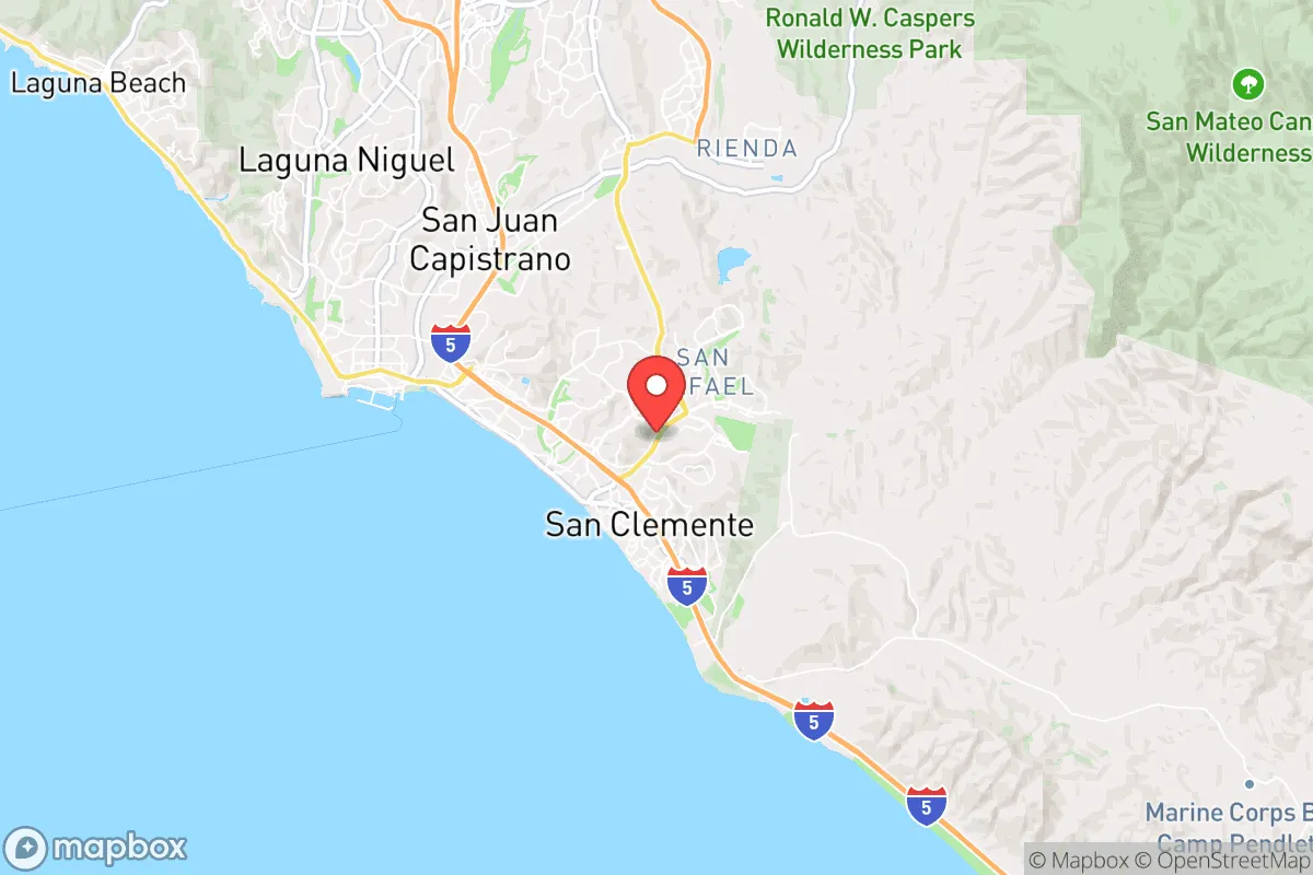
Strategic Assessment of San Clemente, CA
Multiple tactical vulnerabilities. Population density, target proximity, or disaster risk are likely compounding. A retreat property and exit planning is required.
What does the Strategic Assessment tell us?
Our Strategic Assessment grades tactical survivability of an area. Major population centers, military targets, fallout zones, natural disasters, and border exposure all drive risk — lower exposure means a more defensible position in a crisis.
This is heavily inspired by Joel Skousen's Strategic Relocation book. Highly recommended you checkout the book ($)What does this tell us?
Our Strategic Assessment grades tactical survivability of an area. Major population centers, military targets, fallout zones, natural disasters, and border exposure all drive risk — lower exposure means a more defensible position in a crisis.
This is heavily inspired by Joel Skousen's Strategic Relocation book. Highly recommended you checkout the book ($)Strategic Pillars

Key Distances
Regional Safe Places
Below is our recommended "safe zones" in California and the surrounding area based on our strategic heuristics. For most people, it's unrealistic to live in a “safe zone” full-time due to work, family or other personal reasons. They tend to be more rural. However, many of these areas are perfect for second homes and retreat properties that double as a vacation home or even a short-term rental.


Important Note: For informational purposes only. This does not mean nothing bad ever happens in the green zones. Please use common sense. This is based on public data and modeled with AI. We tried to take a conservative approach but mistakes happen. We update this regularly as new information becomes available.
Solar Generator Recommendations
Backup power matters more here than in safer locations. We've picked three solar generators across budgets and capacity tiers — start with the budget unit if you only need a few essentials, or step up if you want to run a fridge and HVAC for days at a time.

Jackery Portable Power Station Explorer 300
Budget OptionPower on the Go: Weighing only 11 lbs, it's convenient to set up and store with book-sized foldable solar panels

BLUETTI Portable Power Station AC180
Designed for both indoor and outdoor scenarios, AC180 is highly capable as it has a robost capacity and continuous output power.

EF ECOFLOW DELTA Pro Ultra Power Station
Upgraded PickEcoFlow DELTA Pro Ultra is a whole-home energy system designed to grow with your family. Integrated with the Smart Home Panel 2, it scales to meet your evolving energy needs — keeping your home powered, intelligent, and secure through every stage of life.
We earn a commission, at no additional cost to you.
Strategic Assessment Analysis
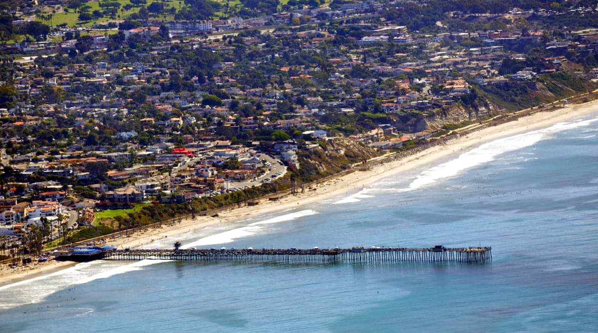
San Clemente occupies a strategic coastal position that offers genuine resilience advantages for those prioritizing disaster readiness and self-sufficiency, but its location also introduces specific vulnerabilities that demand careful consideration. The city sits roughly halfway between Los Angeles and San Diego, placing it within the broader Southern California megaregion while maintaining a degree of physical separation from the densest urban cores. For a relocator weighing long-term security, San Clemente’s mix of ocean access, defensible terrain, and proximity to critical infrastructure creates a nuanced picture—one where the benefits of location must be weighed against exposure to natural hazards and the inherent risks of being near major population centers and potential fallout targets.
Geographic position and natural advantages for long-term security
San Clemente’s geography provides several built-in resilience features that are hard to replicate elsewhere. The city is nestled between the Santa Ana Mountains to the east and the Pacific Ocean to the west, creating a natural buffer zone that limits approach routes and provides multiple escape corridors if needed. The coastal climate moderates temperature extremes, reducing the strain on energy and water systems during heat waves or cold snaps—a meaningful advantage for off-grid or semi-self-sufficient living. The area’s marine layer and onshore breezes also lower wildfire risk compared to inland communities, though not eliminating it entirely. For a relocator thinking about food security, the nearby agricultural valleys of Orange and San Diego counties offer year-round growing seasons and access to local farms, farmers’ markets, and community-supported agriculture networks. The ocean itself provides a protein source and a potential transportation corridor, though reliance on marine resources requires specialized knowledge and equipment. The terrain around San Clemente includes several state parks and open spaces—San Onofre State Beach, Crystal Cove State Park, and the Cleveland National Forest—that could serve as emergency resource zones or retreat areas in a prolonged disruption. These natural assets give San Clemente a baseline resilience that many inland or desert communities lack, but they are not without trade-offs.
Risk exposure, natural hazards, and proximity to fallout-relevant landmarks
The same coastal geography that provides advantages also exposes San Clemente to significant natural risks. The city sits on an active seismic zone, with the San Onofre fault running offshore and the larger San Andreas fault system within 50 miles. A major earthquake could disrupt roads, water lines, and power grids for weeks or months, and the coastal bluffs are prone to landslides and erosion that could sever access routes. Tsunami risk is present but generally low for this stretch of coast, though a large offshore quake could produce dangerous waves. Wildfire risk is moderate but real, particularly in the eastern canyons and hillsides, and Santa Ana wind events can turn a small brush fire into a fast-moving threat. More critically for a strategic assessment, San Clemente’s proximity to high-value infrastructure and population centers introduces man-made risks. The San Onofre Nuclear Generating Station (SONGS), located just south of the city, is decommissioned but still contains spent nuclear fuel stored on-site in dry casks. While the risk of a catastrophic release is low, the presence of this material makes the area a potential target for sabotage or a secondary hazard zone in a major disaster. The city is also within 60 miles of both Los Angeles International Airport and the Port of Long Beach—critical national infrastructure that could be targeted in a conflict or terrorist event. Additionally, the nearby Camp Pendleton Marine Corps Base is a major military installation that could become a primary or secondary target. For a relocator thinking about fallout dangers, San Clemente’s position within the broader Southern California urban corridor means it is not remote enough to avoid the cascading effects of a major event in Los Angeles or San Diego—refugee flows, supply chain disruptions, and potential civil unrest could all reach the area within days.
Practical resilience for a relocator: food, water, energy, and defensibility
San Clemente’s practical resilience for a self-sufficient relocator is a mixed bag. Water is the most critical vulnerability. The city relies on imported water from the Colorado River and the State Water Project, both of which are vulnerable to drought, earthquake damage, and infrastructure failure. Local groundwater is limited and often brackish, and desalination—while possible—requires significant energy and capital. A serious relocator would need to invest in rainwater catchment, storage tanks, and possibly a well, though well permits are difficult to obtain in this coastal zone. Food resilience is better: the region’s mild climate allows for year-round gardening, and the nearby agricultural areas provide backup supply lines. Farmers’ markets operate weekly, and several local farms offer CSA shares. For energy, San Clemente has good solar potential, with over 260 sunny days per year, and many homes already have rooftop solar. Net metering policies are favorable, though grid dependence remains a factor. Battery storage is increasingly common and recommended for anyone serious about energy independence. Defensibility is a double-edged sword. The city’s layout—with a few main arteries (Interstate 5, El Camino Real, and Avenida Del Mar) and limited canyon roads—means that chokepoints can be controlled, but it also means that evacuation routes are limited and can become clogged quickly. The terrain offers some natural defensibility, particularly in the hillside neighborhoods, but the dense suburban development in the lower areas makes perimeter security difficult. For a family or individual, the best approach is to choose a home on the eastern edge of town, near the open space of the Cleveland National Forest, where escape routes into the backcountry are more accessible and the neighborhood density is lower.
The overall strategic picture for San Clemente is one of calculated trade-offs. It offers genuine resilience advantages—coastal climate, agricultural access, moderate wildfire risk, and a location that is close to critical resources without being in the heart of a major city. But those advantages come with real exposure to earthquake risk, water vulnerability, and the unavoidable reality of being within the Southern California megaregion. For a relocator who is serious about disaster readiness and self-sufficiency, San Clemente works best as a base that requires active preparation: robust water storage, solar-plus-battery energy systems, a well-stocked pantry, and a clear evacuation plan for both natural and man-made events. It is not a remote bug-out location, nor is it a high-risk urban center—it sits in a middle ground that rewards preparation and punishes complacency. For those willing to invest in infrastructure and maintain situational awareness, San Clemente can be a resilient and livable choice. For those looking for a turnkey safe haven, the trade-offs may be too steep.
* Values derived from national, state, county, city and local statistics and may differ in a specific area. Last updated: 2026-06-08T04:46:24.000Z
Narrative content on this page is AI-generated and may contain mistakes. Verify any details that matter before acting on them.
ReloMaps may earn a commission from affiliate links at no extra cost to you.