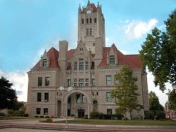
Photo: Wikipedia
Demographics of Hancock County
Affluence Level in Hancock County
An upper-middle-class area. Household wealth, education levels, and homeownership run ahead of national benchmarks.
People of Hancock County
Hancock County, Indiana, today is a predominantly white, family-oriented suburban community of 82,013 residents, characterized by its blend of agricultural heritage and Indianapolis-commuter culture. The county’s population is notably less diverse than the state average, with 89.3% identifying as white, a foreign-born population of just 1.0%, and a median household income that reflects its role as a stable, middle-to-upper-middle-class bedroom community. Distinctive identity markers include a strong local sports tradition centered on Greenfield-Central High School, a deep-rooted sense of small-town civic pride, and a political landscape that leans conservative, with the county voting Republican in every presidential election since 2000.
Settlement & growth (pre-1960)
Before American settlement, the land that became Hancock County was part of the traditional territory of the Miami and Lenape (Delaware) nations, who used the area for hunting and seasonal camps along the Blue River and Brandywine Creek. The 1818 Treaty of St. Mary’s ceded this land to the U.S. government, opening it to white settlement. The county was formally organized in 1828, carved from Madison County, and named after John Hancock, the first signer of the Declaration of Independence.
The first wave of settlers were primarily of Scots-Irish and English descent, arriving from Kentucky, Ohio, and the Mid-Atlantic states between 1820 and 1850. They were drawn by the promise of cheap, fertile land in the newly surveyed townships. The county seat, Greenfield, was platted in 1828 and quickly became the commercial and political hub. These early settlers were subsistence farmers, growing corn and wheat and raising livestock. The National Road (U.S. 40), completed through the county in the 1830s, brought a steady stream of migrants and connected Greenfield to the broader frontier economy.
A second, smaller wave arrived with the Pennsylvania Dutch (German) migration in the 1840s and 1850s. These families, often from southeastern Pennsylvania, settled primarily in the northern townships, including Fortville and McCordsville, where they established prosperous farms and built the area’s first Lutheran and German Reformed churches. Their influence is still visible in the county’s place names and the prevalence of German surnames among long-time residents.
The post-Civil War period saw slow, steady growth driven by agriculture and the arrival of the railroad. The Indianapolis, Cincinnati and Lafayette Railroad reached Greenfield in 1853, and later spur lines connected Wilkinson, Shirley, and Maxwell. These towns became shipping points for grain, hogs, and timber. The county’s population grew from 11,000 in 1850 to 20,000 by 1900, almost entirely native-born white stock. There was no significant industrial or immigrant boom; Hancock County remained a quiet, agrarian corner of central Indiana.
The 20th century brought two notable shifts. First, the automobile industry in nearby Indianapolis created a small commuting class after World War I, with some workers moving to Greenfield and Cumberland for cheaper land. Second, the post-World War II baby boom and the expansion of U.S. 40 and later Interstate 70 triggered the first wave of suburbanization. By 1960, the county’s population had reached 26,000, with Greenfield absorbing most of the growth. The population was still over 99% white, and the foreign-born share was negligible.
Modern era (post-1965)
The 1965 Hart-Cellar Act had almost no direct impact on Hancock County. Unlike the urban cores of Indianapolis or Chicago, the county did not receive significant immigration from Asia, Latin America, or Africa. The foreign-born population today stands at just 1.0%, a figure that has barely budged since 1970. Instead, the county’s modern demographic story is one of domestic migration and suburban spillover from Indianapolis.
The major shift began in the 1980s and accelerated after 2000: the construction of Interstate 70 and the expansion of State Road 9 made Hancock County a viable commuter option for Indianapolis professionals. McCordsville and Fortville transformed from farm hamlets into fast-growing suburbs, with new subdivisions, strip malls, and schools. McCordsville’s population grew from 1,200 in 2000 to over 8,000 by 2023, making it the county’s second-largest town. Greenfield expanded its footprint westward toward the Marion County line, annexing farmland for housing developments aimed at families seeking larger lots and lower taxes than Indianapolis proper.
This domestic in-migration has been overwhelmingly white and middle-class. The county’s Hispanic population, at 3.2%, is the largest minority group, concentrated in Greenfield and Fortville, where they work in construction, landscaping, and food processing. The Black population, at 3.1%, is smaller and more dispersed, with a slight concentration in Greenfield’s older neighborhoods. East and Southeast Asian residents (0.5%) and Indian-subcontinent residents (0.4%) are present in very small numbers, mostly in professional households in McCordsville and the newer subdivisions near the Hancock-Marion county line. The county’s college-educated share, at 34.2%, is slightly below the national average but rising, driven by the influx of white-collar commuters.
Politically, the county has moved rightward. In 2020, Donald Trump won Hancock County with 67% of the vote, up from 62% in 2016. The county’s Republican identity is reinforced by its evangelical churches, strong gun culture, and opposition to Indianapolis’s more liberal policies. Local school boards and town councils are uniformly Republican.
The future
Hancock County is projected to continue growing, reaching an estimated 100,000 residents by 2040, driven entirely by domestic migration from Indianapolis and other parts of central Indiana. The county will likely become slightly more diverse, but at a slow pace. The Hispanic share may rise to 5-6% as families follow construction and service jobs, and the Black share may inch toward 4-5% as some Black professionals seek affordable suburban housing. However, the county will remain overwhelmingly white and native-born, with no major immigrant enclave forming.
The growth will concentrate in the western townships—McCordsville, Fortville, and the Greenfield west side—where land is still available for development. The eastern townships, including Shirley and Wilkinson, will remain rural and slow-growing. The county’s cultural identity is evolving from a purely agricultural community to a hybrid: a conservative, family-oriented suburb that values low taxes, good schools, and proximity to Indianapolis without its urban problems. The tension between long-time farming families and new commuters will persist, but the commuters are winning demographically.
For a prospective resident, Hancock County offers a stable, safe, and politically conservative environment with strong schools and a low cost of living. It is not a place of rapid demographic change or cultural diversity. The county’s future is one of steady, managed growth—more subdivisions, more strip malls, and more commuters—but its fundamental character as a white, middle-class, Republican-leaning suburb is unlikely to shift meaningfully in the next two decades.

* Values derived from national, state, county, city and local statistics and may differ in a specific area. Last updated: 2026-07-26T23:10:54.000Z
Narrative content on this page is AI-generated and may contain mistakes. Verify any details that matter before acting on them.
ReloMaps may earn a commission from affiliate links at no extra cost to you.

