Photo: Wikipedia
Strategic Assessment of Power County
Deep buffer from population centers and strategic targets. Low natural disaster risk and minimal exposure to border or coastal threats.
What does the Strategic Assessment tell us?
Our Strategic Assessment grades tactical survivability of an area. Major population centers, military targets, fallout zones, natural disasters, and border exposure all drive risk — lower exposure means a more defensible position in a crisis.
This is heavily inspired by Joel Skousen's Strategic Relocation book. Highly recommended you checkout the book ($)What does this tell us?
Our Strategic Assessment grades tactical survivability of an area. Major population centers, military targets, fallout zones, natural disasters, and border exposure all drive risk — lower exposure means a more defensible position in a crisis.
This is heavily inspired by Joel Skousen's Strategic Relocation book. Highly recommended you checkout the book ($)Strategic Pillars

Key Distances
Strategic Assessment Analysis
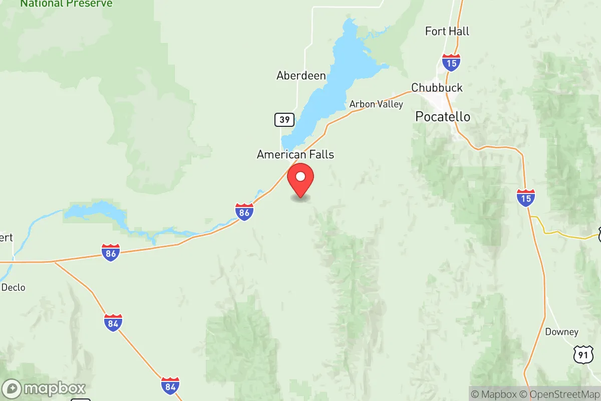
Power County, Idaho, offers a strategic relocation option for those prioritizing resilience, self-sufficiency, and distance from the vulnerabilities of major urban centers. Its position along the Snake River Plain provides a rare combination of agricultural capacity, water access, and low population density—key factors for weathering civic unrest or large-scale disruptions. The county’s seat, American Falls, anchors a region that balances rural isolation with enough infrastructure to sustain a prepared household, making it a serious candidate for those who view current national trends with caution.
Geographic position and natural advantages for long-term stability
Power County sits at a geographic sweet spot: far enough from the chaos of the Wasatch Front and Boise metro areas (roughly 160 miles southeast of Boise) to avoid their fallout risks, yet close enough to access supply routes like Interstate 86 and U.S. Highway 30. The Snake River runs through the county’s heart, providing a reliable surface water source that is rare in the arid West. The American Falls Reservoir, formed by the American Falls Dam, is a critical asset—it stores irrigation water for the region’s farms and could serve as a long-term water supply for a prepared community. The surrounding landscape is a mix of sagebrush steppe and irrigated cropland, offering defensible terrain with clear sightlines and limited cover for unwanted movement. The nearby Fort Hall Indian Reservation adds a layer of cultural and economic stability, with the Shoshone-Bannock Tribes managing substantial land and resources that buffer the county from external shocks. For a relocator, this means a location that is not a primary target for any strategic strike—no major military bases, refineries, or ports within 50 miles—while still being connected to the outside world via rail (the Union Pacific mainline runs through American Falls) and highway.
Risks, exposures, and proximity to fallout-relevant landmarks
No location is without risk, and Power County has specific exposures that a serious prepper must account for. The most obvious is the American Falls Dam itself—a concrete gravity dam built in the 1920s. While it is well-maintained by the U.S. Bureau of Reclamation, any catastrophic failure (from seismic activity or sabotage) would inundate the low-lying areas of American Falls and downstream communities along the Snake River. The county also sits within 100 miles of the Idaho National Laboratory (INL) near Idaho Falls, a sprawling nuclear research facility that handles radioactive materials. A major accident or targeted attack at INL could produce a fallout plume that, depending on wind patterns, might affect eastern Power County. Additionally, the Pocatello Regional Airport (about 30 miles north) and the Union Pacific rail yard in Pocatello are moderate-risk transportation hubs that could draw secondary disruptions during civil unrest. On the positive side, Power County has no major petrochemical refineries, no large-scale military installations, and no dense urban populations—the entire county’s population is under 8,000, with American Falls housing about 4,500. This low profile is a strategic advantage: it is unlikely to be a target for any coordinated attack or a flashpoint for mass casualty events. The nearest city of any size is Pocatello (pop. 58,000), which is small enough to avoid the systemic collapse risks of a major metro but large enough to attract looting or resource competition during a crisis.
Practical resilience for a relocator: food, water, energy, and defensibility
For a relocator focused on self-reliance, Power County delivers on the basics. Water is the strongest asset: the Snake River and American Falls Reservoir provide year-round surface water, and the local aquifer is accessible via shallow wells in most areas. The county’s agricultural base means that food production is viable—irrigated farms grow potatoes, wheat, alfalfa, and sugar beets, and the region supports cattle ranching. A prepared household could secure a small plot of irrigated land or partner with local farmers for barter arrangements. Energy is less certain: the grid is served by Idaho Power, which relies on a mix of hydro, natural gas, and coal. The American Falls Dam generates hydroelectric power, but a grid-down scenario would leave most residents without electricity unless they have solar panels or a generator. The area’s high desert climate (average 12 inches of precipitation annually) means solar is viable, but winter cloud cover can reduce output. Defensibility is good but not fortress-like. The terrain is open, with few natural choke points, but the low population density means a prepared group can establish a perimeter around a homestead without constant intrusion. The county’s law enforcement presence is minimal—the Power County Sheriff’s Office has about a dozen deputies—so self-defense capability is essential. The nearest National Guard armory is in Pocatello, which is a 30-minute drive, but during widespread unrest, response times would be measured in days, not hours. For a relocator, the key is to arrive with supplies, skills, and a network—this is not a place to show up unprepared and expect the government to provide.
The overall strategic picture for Power County is one of calculated trade-offs. It offers genuine resilience in water, food, and isolation, but demands that a relocator bring their own energy solutions, security measures, and community connections. The risks from the dam and INL are real but manageable with proper planning—avoid low-lying flood zones and monitor wind patterns during any nuclear incident. For a conservative-leaning individual or family looking to step away from the fragility of urban life, Power County provides a solid foundation. It is not a bug-out location for a weekend; it is a long-term base for those willing to invest in preparation and accept the trade-offs of rural living. The county’s quiet position in the Snake River Plain, far from the chaos of the coasts and the vulnerability of major infrastructure, makes it a serious contender for anyone who sees the current trajectory of the country as unstable and wants a place to ride it out.
* Values derived from national, state, county, city and local statistics and may differ in a specific area. Last updated: 2026-05-22T15:39:14.000Z
Narrative content on this page is AI-generated and may contain mistakes. Verify any details that matter before acting on them.
ReloMaps may earn a commission from affiliate links at no extra cost to you.