
Photo: Wikipedia
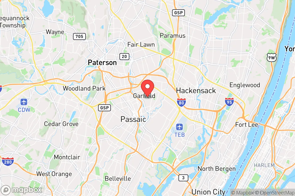
Strategic Assessment of Garfield, NJ
High tactical risk. This location is likely close to major population centers, strategic targets, or sits in a high-disaster corridor. A retreat property and careful exit planning is required.
What does the Strategic Assessment tell us?
Our Strategic Assessment grades tactical survivability of an area. Major population centers, military targets, fallout zones, natural disasters, and border exposure all drive risk — lower exposure means a more defensible position in a crisis.
This is heavily inspired by Joel Skousen's Strategic Relocation book. Highly recommended you checkout the book ($)What does this tell us?
Our Strategic Assessment grades tactical survivability of an area. Major population centers, military targets, fallout zones, natural disasters, and border exposure all drive risk — lower exposure means a more defensible position in a crisis.
This is heavily inspired by Joel Skousen's Strategic Relocation book. Highly recommended you checkout the book ($)Strategic Pillars

Key Distances
Regional Safe Places
Below is our recommended "safe zones" in New Jersey and the surrounding area based on our strategic heuristics. For most people, it's unrealistic to live in a “safe zone” full-time due to work, family or other personal reasons. They tend to be more rural. However, many of these areas are perfect for second homes and retreat properties that double as a vacation home or even a short-term rental.


Important Note: For informational purposes only. This does not mean nothing bad ever happens in the green zones. Please use common sense. This is based on public data and modeled with AI. We tried to take a conservative approach but mistakes happen. We update this regularly as new information becomes available.
Solar Generator Recommendations
Backup power matters more here than in safer locations. We've picked three solar generators across budgets and capacity tiers — start with the budget unit if you only need a few essentials, or step up if you want to run a fridge and HVAC for days at a time.

Jackery Portable Power Station Explorer 300
Budget OptionPower on the Go: Weighing only 11 lbs, it's convenient to set up and store with book-sized foldable solar panels

BLUETTI Portable Power Station AC180
Designed for both indoor and outdoor scenarios, AC180 is highly capable as it has a robost capacity and continuous output power.

EF ECOFLOW DELTA Pro Ultra Power Station
Upgraded PickEcoFlow DELTA Pro Ultra is a whole-home energy system designed to grow with your family. Integrated with the Smart Home Panel 2, it scales to meet your evolving energy needs — keeping your home powered, intelligent, and secure through every stage of life.
We earn a commission, at no additional cost to you.
Strategic Assessment Analysis
Garfield, New Jersey, sits in a precarious but potentially strategic pocket for those serious about resilience. Its location within Bergen County offers proximity to critical infrastructure and resources, yet its position in the densely packed New York metropolitan area introduces significant vulnerabilities that a prepper must weigh carefully. For a conservative-leaning individual or family prioritizing self-reliance, Garfield presents a mixed picture: it is not a remote redoubt, but it does offer specific geographic advantages that can be leveraged for short-term survival and medium-term stability, provided you understand the risks.
Geographic position and natural advantages for a prepper
Garfield’s primary strategic asset is its location along the Passaic River, which provides a natural water source—a critical resource in any extended disruption. The city itself is situated on relatively flat terrain, which simplifies defensive positioning and reduces the risk of landslides or washouts common in more mountainous areas. Its position roughly 12 miles from Manhattan means it is close enough to access major supply chains and medical facilities in a crisis, but far enough that the immediate chaos of a city-wide event may not overwhelm the area in the first hours. The surrounding region includes the Ramapo Mountains and the Highlands to the northwest, offering potential retreat zones if Garfield itself becomes untenable. For a relocator, the key advantage is that Garfield sits at a crossroads of major highways (Route 21, the Garden State Parkway, and I-80), which can be used for evacuation or resupply, though these same routes become liabilities during a mass evacuation. The city’s grid layout, while not ideal for defense, does allow for clear lines of sight and predictable movement patterns—useful for establishing neighborhood watch or perimeter security.
Risks, exposures, and proximity to fallout-relevant landmarks
The most glaring risk for Garfield is its proximity to high-value, high-risk targets. Newark Liberty International Airport is roughly 10 miles south, and the Port of Newark and Elizabeth—a major container port and potential chokepoint for national supply chains—is within 15 miles. These are prime targets for both state-level adversaries and domestic disruption. Additionally, the city lies within the fallout shadow of any nuclear event targeting New York City or the numerous chemical plants along the New Jersey Turnpike corridor. The Meadowlands, just east, contain Superfund sites and industrial facilities that could release toxic plumes depending on wind direction. Garfield itself has a history of industrial use, meaning soil and water contamination are real concerns for long-term habitation. For the prepper, the biggest exposure is population density: Garfield has over 30,000 residents in just 2.2 square miles. In a collapse scenario, that density means competition for resources, higher disease transmission risk, and difficulty in maintaining operational security. The city’s reliance on the New York City water supply system (via the Passaic Valley Water Commission) is another vulnerability—any disruption to that system would leave residents without potable water unless they have independent storage or filtration.
Practical resilience for a relocator: food, water, energy, and defensibility
For a relocator willing to invest in hardening, Garfield offers some practical advantages. Water is the most critical: the Passaic River runs directly through the city, and while it is heavily polluted, a good filtration system (e.g., a Berkey or a Sawyer filter) can make it usable for hygiene and, with proper treatment, drinking. The city’s water table is high, so shallow wells are possible on larger properties, though permits and contamination are issues. Food security is more challenging. Garfield has a few small grocery stores and bodegas, but the area is not agricultural—there is no significant farmland within city limits. A prepper would need to rely on stockpiling, community barter, or establishing a rooftop or backyard garden. The city’s energy grid is typical of the Northeast: overhead lines vulnerable to storms and sabotage. Solar panels with battery storage are feasible, but roof space is limited on the dense housing stock. Natural gas is widely available, which can be used for cooking and heating if the grid stays up, but a propane backup is wise. Defensibility is the weakest point. Garfield’s street grid and small lot sizes make it hard to create a secure perimeter. However, the city’s many brick and concrete buildings offer good ballistic protection. A relocator should focus on a single-family home with a basement (for shelter and storage) and a fenced yard. The presence of multiple churches and community centers could serve as rally points or distribution hubs in a coordinated neighborhood response. The key is to build relationships with neighbors before a crisis—a lone prepper in a dense urban environment is a target, but a well-organized block can be a formidable unit.
The overall strategic picture for Garfield is one of calculated risk. It is not a survivalist’s paradise—it lacks the isolation, natural resources, and defensible terrain of a rural retreat. But for someone who must remain near the New York metro area for work or family, it offers a reasonable compromise. The city’s location on a major river, its access to multiple transport corridors, and its dense but manageable population mean that a prepared individual can ride out many short-term disruptions. The long-term viability, however, depends on factors outside the city’s control: the stability of the regional power grid, the integrity of the water supply, and the behavior of the surrounding population during a crisis. For a conservative relocator who values community, self-reliance, and a realistic assessment of threats, Garfield is a place to be approached with eyes wide open—not a fortress, but a foothold. The smart move is to treat it as a base of operations, not a final destination, and to have a bug-out plan for the Highlands or Pennsylvania if the situation deteriorates beyond what urban resilience can handle.
* Values derived from national, state, county, city and local statistics and may differ in a specific area. Last updated: 2026-04-29T21:12:44.000Z
Narrative content on this page is AI-generated and may contain mistakes. Verify any details that matter before acting on them.
ReloMaps may earn a commission from affiliate links at no extra cost to you.