Photo: Wikipedia
Strategic Assessment of Douglas County
Workable tactical position. Some exposure to population density or targets, but generally defensible in a crisis.
What does the Strategic Assessment tell us?
Our Strategic Assessment grades tactical survivability of an area. Major population centers, military targets, fallout zones, natural disasters, and border exposure all drive risk — lower exposure means a more defensible position in a crisis.
This is heavily inspired by Joel Skousen's Strategic Relocation book. Highly recommended you checkout the book ($)What does this tell us?
Our Strategic Assessment grades tactical survivability of an area. Major population centers, military targets, fallout zones, natural disasters, and border exposure all drive risk — lower exposure means a more defensible position in a crisis.
This is heavily inspired by Joel Skousen's Strategic Relocation book. Highly recommended you checkout the book ($)Strategic Pillars

Key Distances
Strategic Assessment Analysis
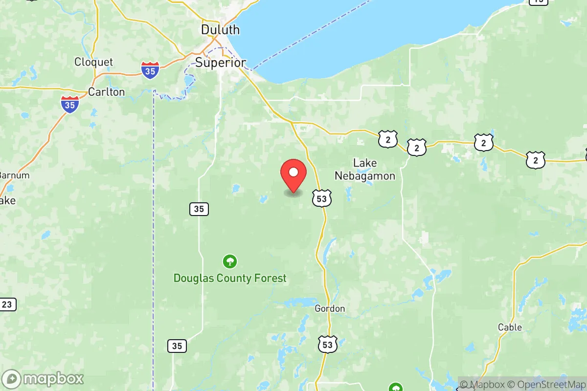
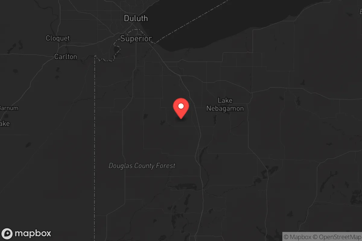
Douglas County, Wisconsin, offers a compelling strategic position for those prioritizing resilience and self-sufficiency, particularly for conservative-leaning individuals and families looking to distance themselves from the vulnerabilities of major urban centers. Located in the northwestern corner of the state, this region provides a buffer from the dense populations and critical infrastructure targets of the Midwest, while still maintaining access to essential resources. The county’s low population density—roughly 44,000 residents spread over 1,304 square miles—combined with its proximity to Lake Superior and the St. Louis River, creates a natural stronghold for those serious about long-term preparedness.
Geographic position and natural advantages for long-term security
Douglas County sits at a strategic crossroads, bordered by Lake Superior to the north and the state of Minnesota to the west. The county seat, Superior, is a small city of about 26,000 people, but it’s the only significant population center—most of the county is rural forest and farmland. This geography offers a natural defensive buffer: the lake provides a massive freshwater resource, while the dense boreal forests of the Chequamegon-Nicolet National Forest to the east and the Brule River State Forest to the south create a physical barrier against easy overland movement. The county’s position also places it far from the major fallout corridors of the Midwest—think the Twin Cities (about 150 miles south), Duluth (just across the bay but a separate metro), or the Chicago-Milwaukee corridor. For a relocator, this means you’re not in the immediate blast or fallout zone of any major military or industrial target. The local terrain—rolling hills, mixed hardwood and conifer forests, and numerous small lakes—also provides ample cover and natural resources for off-grid living. The Superior Municipal Forest, a 4,500-acre urban forest within the city limits, is a unique asset for quick access to timber and game without leaving town.
Risks, exposures, and proximity to fallout-relevant landmarks
No location is without risk, and Douglas County has its own set of strategic exposures. The most immediate concern is the city of Duluth, Minnesota, just across the St. Louis River and the Superior Bay. Duluth is a major Great Lakes port and a hub for shipping iron ore, coal, and grain. While not a primary nuclear target, it’s a secondary economic node that could see civil unrest or infrastructure disruption in a crisis. The Superior refinery (the Husky Energy refinery, now owned by Cenovus) is a concrete risk: it processes about 45,000 barrels of crude oil per day and sits on the waterfront. A major accident or targeted attack there could create a toxic plume or fire hazard for downwind areas. Additionally, the Duluth Air National Guard Base (part of the 148th Fighter Wing) operates F-16s from the Duluth International Airport, making it a potential military target in a conflict scenario. The county also has a small but active rail line running through Superior and into the interior, carrying hazardous materials like propane and ammonia. On the plus side, there are no nuclear power plants within 100 miles—the closest is the Prairie Island plant near Red Wing, MN, about 180 miles south. The risk of fallout from a major strike on the Twin Cities is real but manageable: prevailing winds in this region tend to blow from the west and northwest, meaning fallout from a Minneapolis-St. Paul event would likely push east into Wisconsin, but Douglas County is far enough north to be on the fringe. The key takeaway: you’re not in a primary target zone, but you’re close enough to feel secondary effects—plan accordingly.
Practical resilience for a relocator: food, water, energy, and defensibility
For a family or individual serious about self-reliance, Douglas County offers strong fundamentals. Water is abundant: Lake Superior is the largest freshwater lake in the world by surface area, and the county is dotted with smaller lakes like Lake Nebagamon, Upper St. Croix Lake, and the Brule River. Groundwater is generally good, though well depth varies—most rural properties tap into the Cambrian sandstone aquifer at 100-300 feet. Food production is viable but not easy: the growing season is short (about 120 frost-free days), and the soil is sandy and acidic in many areas. However, the county has a strong hunting culture—white-tailed deer, black bear, and small game are plentiful—and the Lake Superior fishery provides lake trout, whitefish, and salmon. For long-term food storage, the cold climate is a natural advantage: root cellars and cold storage are effective for 8-9 months of the year. Energy independence is achievable: solar panels work here despite the northern latitude (about 4.5 peak sun hours per day in summer), but winter cloud cover is a challenge. Wood heat is the most practical backup—the county is heavily forested, and firewood permits are cheap. The local power grid is served by Minnesota Power and Superior Water, Light & Power, but rural areas are prone to outages from ice storms and wind events. Defensibility is a mixed bag: the terrain offers natural chokepoints (the bridges over the St. Louis River, the narrow corridors along Highway 2 and 53), but the county’s long border with Minnesota and Lake Superior means you can’t fully seal it off. The best approach is to choose a property with good sightlines, a reliable water source, and access to multiple egress routes—avoid the floodplains along the Nemadji River and the low-lying areas near the lake. The local sheriff’s office is small (about 40 deputies), so don’t count on rapid response in a widespread event.
The overall strategic picture for Douglas County is one of moderate risk with high potential for those willing to put in the work. You’re far enough from the major fallout zones and population centers to avoid the worst of a national crisis, but close enough to the Twin Cities and Duluth to face secondary effects like refugees, supply chain disruptions, or localized unrest. The natural resources—water, timber, game—are excellent, and the climate, while harsh in winter, is a built-in deterrent to unprepared outsiders. For a conservative-leaning relocator who values independence, community (the county has a strong rural culture and a growing number of like-minded homesteaders), and a low-tax environment (Wisconsin has no estate tax and relatively low property taxes compared to Minnesota), this is a solid B+ location. It’s not a bug-out paradise—you’ll need to invest in infrastructure, learn to deal with snow and cold, and accept that you’re not completely isolated. But if you’re looking for a place where you can build a resilient life without being on anyone’s target list, Douglas County deserves a serious look.
* Values derived from national, state, county, city and local statistics and may differ in a specific area. Last updated: 2026-06-06T21:38:18.000Z
Narrative content on this page is AI-generated and may contain mistakes. Verify any details that matter before acting on them.
ReloMaps may earn a commission from affiliate links at no extra cost to you.