
Photo: Wikipedia
Strategic Assessment of West Columbia, SC
Meaningful friction. Expect exposure to either population pressure, blast zones, or natural disaster risk. Consider buying a retreat property.
What does the Strategic Assessment tell us?
Our Strategic Assessment grades tactical survivability of an area. Major population centers, military targets, fallout zones, natural disasters, and border exposure all drive risk — lower exposure means a more defensible position in a crisis.
This is heavily inspired by Joel Skousen's Strategic Relocation book. Highly recommended you checkout the book ($)What does this tell us?
Our Strategic Assessment grades tactical survivability of an area. Major population centers, military targets, fallout zones, natural disasters, and border exposure all drive risk — lower exposure means a more defensible position in a crisis.
This is heavily inspired by Joel Skousen's Strategic Relocation book. Highly recommended you checkout the book ($)Strategic Pillars

Key Distances
Regional Safe Places
Below is our recommended "safe zones" in South Carolina and the surrounding area based on our strategic heuristics. For most people, it's unrealistic to live in a “safe zone” full-time due to work, family or other personal reasons. They tend to be more rural. However, many of these areas are perfect for second homes and retreat properties that double as a vacation home or even a short-term rental.


Important Note: For informational purposes only. This does not mean nothing bad ever happens in the green zones. Please use common sense. This is based on public data and modeled with AI. We tried to take a conservative approach but mistakes happen. We update this regularly as new information becomes available.
Solar Generator Recommendations
Backup power matters more here than in safer locations. We've picked three solar generators across budgets and capacity tiers — start with the budget unit if you only need a few essentials, or step up if you want to run a fridge and HVAC for days at a time.

Jackery Portable Power Station Explorer 300
Budget OptionPower on the Go: Weighing only 11 lbs, it's convenient to set up and store with book-sized foldable solar panels

BLUETTI Portable Power Station AC180
Designed for both indoor and outdoor scenarios, AC180 is highly capable as it has a robost capacity and continuous output power.

EF ECOFLOW DELTA Pro Ultra Power Station
Upgraded PickEcoFlow DELTA Pro Ultra is a whole-home energy system designed to grow with your family. Integrated with the Smart Home Panel 2, it scales to meet your evolving energy needs — keeping your home powered, intelligent, and secure through every stage of life.
We earn a commission, at no additional cost to you.
Strategic Assessment Analysis
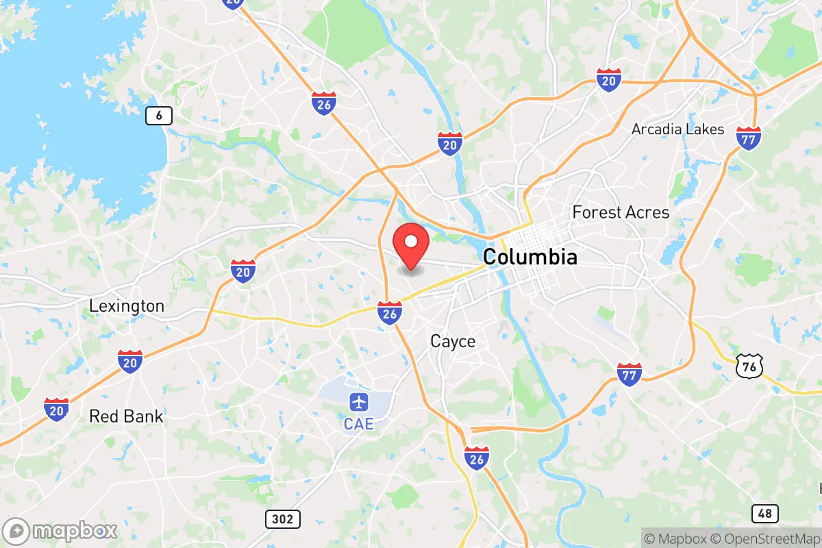
West Columbia, South Carolina, presents a mixed bag for the strategic relocator. Its resilience is tied directly to its position on the western bank of the Congaree River, offering a buffer from the densest urban core of Columbia while still being close enough to leverage the capital's infrastructure. This location provides a unique blend of access and separation, but the proximity to a state capital and major interstate corridors introduces significant vulnerabilities that a prepper must weigh carefully. The area's advantages are real, but they come with strings attached that require a clear-eyed assessment.
Geographic position and natural advantages for a strategic relocation
West Columbia sits in a sweet spot of the South Carolina Midlands, roughly 90 miles from the coast and 100 miles from the Blue Ridge foothills. This inland position provides a natural buffer against the worst of hurricane storm surge, which historically devastates coastal communities like Charleston or Myrtle Beach. The area's elevation averages around 250 feet above sea level, and while flash flooding from the Congaree River is a periodic concern, the town itself is not in a floodplain for most residential neighborhoods. The surrounding terrain is rolling Piedmont, offering decent drainage and a mix of hardwood and pine forests that provide both cover and resources. For a relocator, the key advantage is the ability to tap into the resources of the Columbia metropolitan area—hospitals, supply chains, and transportation hubs—while maintaining a separate, more defensible footprint on the river's west side. The presence of the Congaree River also offers a natural water source, though its reliability and purity in a crisis scenario require careful planning.
Risks, exposures, and proximity to fallout-relevant landmarks
The most glaring vulnerability for West Columbia is its proximity to the city of Columbia proper, a population center of roughly 140,000 that swells to over 800,000 in the metro area. In a scenario of civil unrest or mass casualty event, the bridges across the Congaree—specifically the Blossom Street Bridge, the Gervais Street Bridge, and the I-126 bridge—become chokepoints that could be contested or blocked. If the state capital becomes a target for protest, riot, or coordinated attack, West Columbia sits directly in the path of any spillover. Additionally, the area is within a 20-mile radius of Fort Jackson, a major U.S. Army training base. While this provides a potential security presence, it also makes the region a plausible target for asymmetric threats or infrastructure sabotage. The Columbia Metropolitan Airport (CAE) is just 10 miles east, and the nearby rail lines running through Cayce and West Columbia carry freight that could include hazardous materials. For the survivalist, these are not abstract risks—they are concrete exposure points that demand a layered security and evacuation plan. The area's reliance on the I-26 and I-77 corridors for supply and egress also means that any disruption to those highways could quickly isolate the town.
Practical resilience for a relocator: food, water, energy, and defensibility
On the practical side, West Columbia offers some genuine advantages for a prepared individual or family. The local water supply comes from the Columbia Canal and the Congaree River, treated by the city's water plant. In a grid-down scenario, the river is a viable raw water source, but it requires robust filtration and boiling—industrial runoff and agricultural silt are real concerns. The area's climate supports year-round gardening, with a growing season from March to November, and the sandy loam soil in many neighborhoods is workable for raised beds. Local farmers' markets and the nearby S.C. State Farmers Market in Lexington provide fresh food access in normal times, but a prepper should plan for seed stockpiles and heirloom varieties that can be saved year to year. Energy resilience is a mixed picture: Duke Energy provides the grid, which is moderately reliable but vulnerable to ice storms and hurricane-force winds that can knock out power for days. Solar potential is decent, with an average of 215 sunny days per year, but HOA restrictions in some West Columbia subdivisions can be a barrier. Defensibility is the weakest link. The town is a typical suburban layout with cul-de-sacs and strip malls, not a natural fortress. The best bet for a relocator is to target properties on the western edge of town, closer to the Lexington County line, where lots are larger and neighbors are more spread out. The Lexington County Sheriff's Office has a solid reputation, but response times in a widespread event would be stretched thin. For a single individual or a family, the strategy here is not to hunker down in a suburban tract home but to use West Columbia as a base for building a network of resources and relationships while maintaining a more remote bug-out location within a two-hour drive, such as the Sumter National Forest or the rural areas around Saluda County.
The overall strategic picture for West Columbia is one of calculated trade-offs. It offers the logistical and medical infrastructure of a capital region without the immediate density of downtown, but that proximity is a double-edged sword. For the conservative-leaning relocator who values community stability, local law enforcement presence, and access to supply chains, West Columbia can work—provided you are not naive about the risks. The area's political leanings are mixed, with Lexington County trending conservative while Richland County (across the river) is more liberal, creating a cultural friction zone that could amplify tensions during unrest. The smart play is to treat West Columbia as a forward operating base: invest in a property with good water access, solar capability, and a defensible layout, but maintain the mobility and relationships to leave quickly if the bridges become a liability. It is not a survivalist paradise, but for someone who wants to stay connected to civilization while keeping one eye on the horizon, it is a viable option that demands serious preparation, not passive hope.
* Values derived from national, state, county, city and local statistics and may differ in a specific area. Last updated: 2026-04-30T02:47:49.000Z
Narrative content on this page is AI-generated and may contain mistakes. Verify any details that matter before acting on them.
ReloMaps may earn a commission from affiliate links at no extra cost to you.