Photo: Wikipedia
Strategic Assessment of Bastrop County
Meaningful friction. Expect exposure to either population pressure, blast zones, or natural disaster risk. Consider buying a retreat property.
What does the Strategic Assessment tell us?
Our Strategic Assessment grades tactical survivability of an area. Major population centers, military targets, fallout zones, natural disasters, and border exposure all drive risk — lower exposure means a more defensible position in a crisis.
This is heavily inspired by Joel Skousen's Strategic Relocation book. Highly recommended you checkout the book ($)What does this tell us?
Our Strategic Assessment grades tactical survivability of an area. Major population centers, military targets, fallout zones, natural disasters, and border exposure all drive risk — lower exposure means a more defensible position in a crisis.
This is heavily inspired by Joel Skousen's Strategic Relocation book. Highly recommended you checkout the book ($)Strategic Pillars

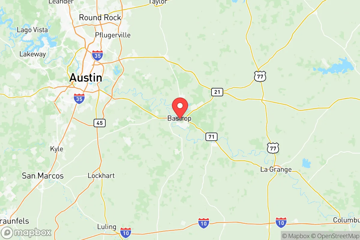
Key Distances
Strategic Assessment Analysis
Bastrop County offers a compelling mix of strategic depth and practical resilience for those looking to put distance between themselves and the most obvious fallout zones, while still staying within a reasonable drive of critical infrastructure. Sitting about 30 miles southeast of Austin’s urban core, the county provides a buffer that’s close enough for supply runs or medical access but far enough to avoid the worst of a city’s collapse—whether that’s from civil unrest, grid failure, or a mass casualty event. The county seat, Bastrop, and the smaller communities of Elgin, Smithville, and Paige form a loose network of low-density settlements that don’t scream “target,” which is exactly the point for a conservative-leaning relocator thinking about the long game.
Geographic position and natural advantages for long-term security
Bastrop County sits at the intersection of the Colorado River and the Lost Pines Forest, a unique ecological zone that gives the area a distinct edge. The Lost Pines—an isolated stand of loblolly pines—provide natural cover and timber resources that are rare in Central Texas, offering both concealment and a renewable building material. The Colorado River runs through the county, creating a reliable surface water source that’s less prone to the severe droughts that plague the Hill Country to the west. The terrain is rolling hills with decent elevation changes, which aids in line-of-sight defensibility and drainage, unlike the flat, exposed plains of the Gulf Coast. The county’s position also puts it outside the immediate blast radius of any major military or industrial targets: Fort Cavazos (formerly Fort Hood) is about 90 miles north, and the Houston Ship Channel’s refinery corridor is roughly 130 miles southeast. That distance is enough to avoid the initial shockwave and fallout plume from a conventional or dirty bomb strike, while still being within a day’s drive if you need to relocate further. The county’s proximity to the Bastrop State Park and Buescher State Park adds a buffer of protected land that’s hard to develop, meaning fewer neighbors and more natural barriers.
Risks, exposures, and proximity to fallout-relevant landmarks
No area is a fortress, and Bastrop County has its share of vulnerabilities that a prepper needs to account for. The most immediate risk is wildfire—the 2011 Bastrop Complex Fire destroyed over 1,600 homes and burned 34,000 acres, and the Lost Pines’ dense vegetation means a dry year can turn the whole county into a tinderbox. That’s a natural disaster risk that’s harder to mitigate than a man-made one. On the man-made side, the county is within the fallout shadow of several high-value targets. The South Texas Nuclear Generating Station near Bay City is about 150 miles south—not a direct threat, but prevailing winds from the south could carry a plume over the county in a worst-case scenario. Closer to home, the Austin-Bergstrom International Airport (about 25 miles west) and the Tesla Gigafactory in Del Valle (about 20 miles northwest) are both potential targets for a coordinated attack or civil unrest spillover. The county’s main highway, Texas State Highway 21, runs straight through Bastrop and connects to I-10, a major evacuation route that could become a choke point during a mass exodus from Houston or San Antonio. The Lower Colorado River Authority’s dams and reservoirs upstream—like the Tom Miller Dam in Austin—could be compromised in a conflict, leading to flash flooding along the river corridor. For a relocator, these aren’t dealbreakers, but they demand a plan: stockpile firebreaks, keep a bug-out route that avoids 21 and 71, and know the wind patterns.
Practical resilience for a relocator: food, water, energy, and defensibility
Bastrop County’s practical resilience hinges on its rural character and the ability to go off-grid without raising eyebrows. Water is the first concern: the Colorado River is a reliable source, but it’s also a public waterway that could be contested. Private wells are common in the county’s unincorporated areas, with depths averaging 200-400 feet to reach the Trinity Aquifer, which is less susceptible to surface contamination than the Edwards Aquifer further west. Rainwater catchment is legal and encouraged, with the county offering tax exemptions for rainwater harvesting systems. For food, the county has a strong agricultural base—cattle ranches, hay farms, and pecan orchards are widespread, and the Bastrop Farmers Market operates year-round, giving you a sense of local food networks. The soil in the river bottoms is fertile enough for personal gardens, though the sandy loam of the Lost Pines requires amendment. Energy is a mixed bag: the county is served by the Bluebonnet Electric Cooperative, which has a decent reliability record, but a grid-down scenario means solar panels with battery storage are a smart investment—the area gets over 220 sunny days per year. Defensibility is where the county shines. The unincorporated areas around Paige and Red Rock offer large parcels (5-20 acres are common) with long driveways and natural tree cover, making them hard to approach without warning. The county’s population density is about 120 people per square mile, but that drops to under 30 in the rural eastern half. Law enforcement presence is thin—the Bastrop County Sheriff’s Office has about 60 deputies for 900 square miles—so you’re largely responsible for your own security. That’s a feature, not a bug, for those who take preparedness seriously.
The overall strategic picture for Bastrop County is one of calculated trade-offs. It’s not a remote mountain redoubt—you’re still within an hour of a major city, and the wildfire risk is real. But for a conservative relocator who wants to stay connected to the Texas economy while building a defensible, self-sufficient property, it’s one of the better bets in Central Texas. The county’s mix of water access, timber resources, and low population density gives you options that the Hill Country or the coastal plains can’t match. The key is to buy land east of Highway 95, away from the Austin sprawl, and invest in fire mitigation and off-grid infrastructure. If the country holds together, you’ve got a peaceful slice of Texas with good schools in Bastrop and Elgin. If it doesn’t, you’ve got a position that’s far enough from the blast zones to survive the first wave, and rugged enough to hold out through the aftermath.
* Values derived from national, state, county, city and local statistics and may differ in a specific area. Last updated: 2026-05-12T20:57:05.000Z
Narrative content on this page is AI-generated and may contain mistakes. Verify any details that matter before acting on them.
ReloMaps may earn a commission from affiliate links at no extra cost to you.