Photo: Wikipedia
Strategic Assessment of Strasburg, CO
Workable tactical position. Some exposure to population density or targets, but generally defensible in a crisis.
What does the Strategic Assessment tell us?
Our Strategic Assessment grades tactical survivability of an area. Major population centers, military targets, fallout zones, natural disasters, and border exposure all drive risk — lower exposure means a more defensible position in a crisis.
This is heavily inspired by Joel Skousen's Strategic Relocation book. Highly recommended you checkout the book ($)What does this tell us?
Our Strategic Assessment grades tactical survivability of an area. Major population centers, military targets, fallout zones, natural disasters, and border exposure all drive risk — lower exposure means a more defensible position in a crisis.
This is heavily inspired by Joel Skousen's Strategic Relocation book. Highly recommended you checkout the book ($)Strategic Pillars

Key Distances
Regional Safe Places
Below is our recommended "safe zones" in Colorado and the surrounding area based on our strategic heuristics. For most people, it's unrealistic to live in a “safe zone” full-time due to work, family or other personal reasons. They tend to be more rural. However, many of these areas are perfect for second homes and retreat properties that double as a vacation home or even a short-term rental.
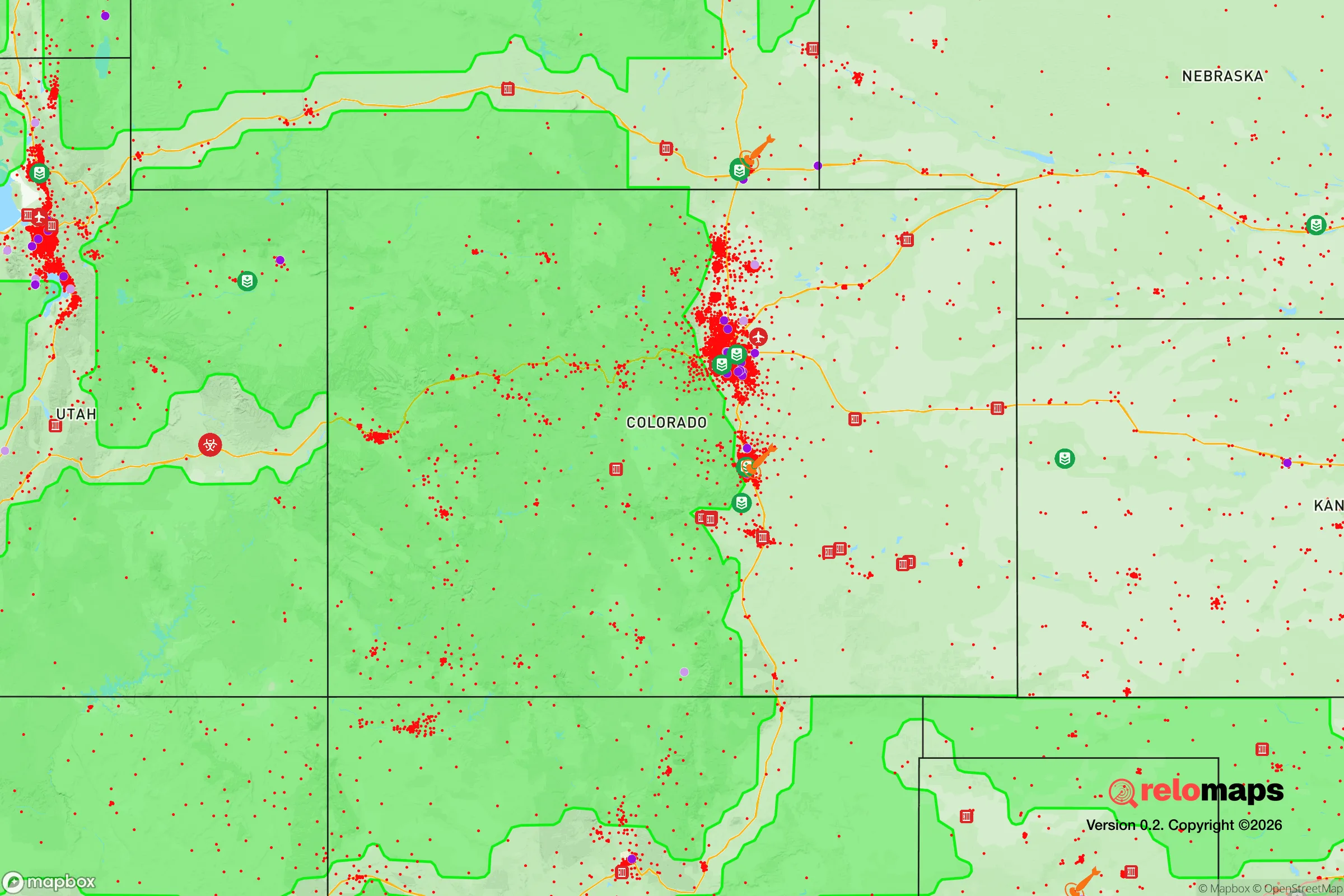
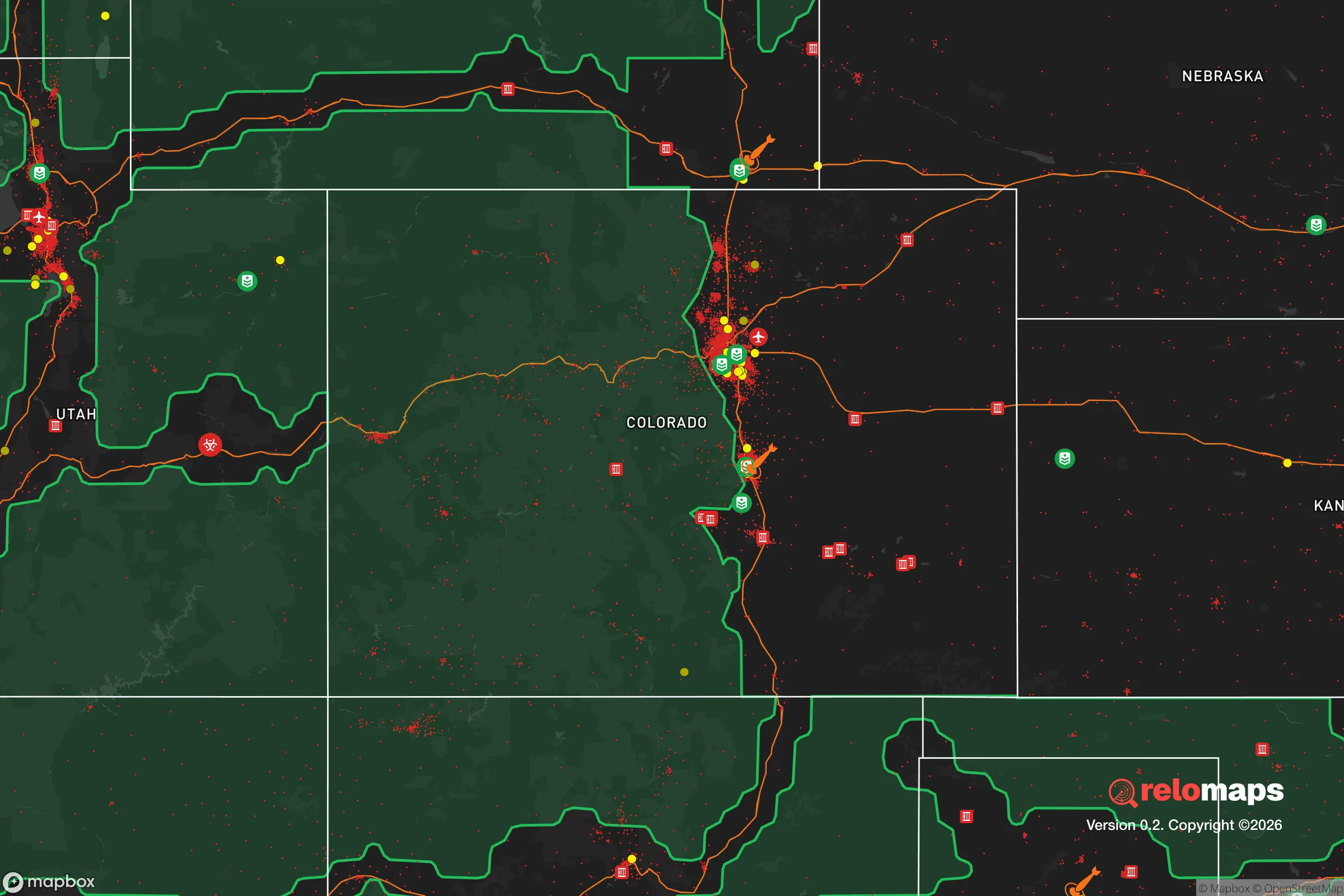


Important Note: For informational purposes only. This does not mean nothing bad ever happens in the green zones. Please use common sense. This is based on public data and modeled with AI. We tried to take a conservative approach but mistakes happen. We update this regularly as new information becomes available.
Solar Generator Recommendations
Backup power matters more here than in safer locations. We've picked three solar generators across budgets and capacity tiers — start with the budget unit if you only need a few essentials, or step up if you want to run a fridge and HVAC for days at a time.

Jackery Portable Power Station Explorer 300
Budget OptionPower on the Go: Weighing only 11 lbs, it's convenient to set up and store with book-sized foldable solar panels

BLUETTI Portable Power Station AC180
Designed for both indoor and outdoor scenarios, AC180 is highly capable as it has a robost capacity and continuous output power.

EF ECOFLOW DELTA Pro Ultra Power Station
Upgraded PickEcoFlow DELTA Pro Ultra is a whole-home energy system designed to grow with your family. Integrated with the Smart Home Panel 2, it scales to meet your evolving energy needs — keeping your home powered, intelligent, and secure through every stage of life.
We earn a commission, at no additional cost to you.
Strategic Assessment Analysis
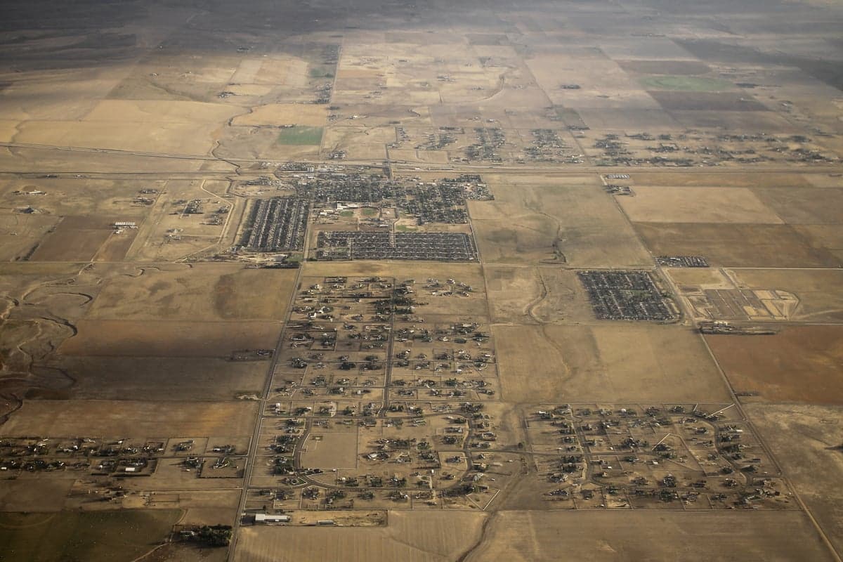
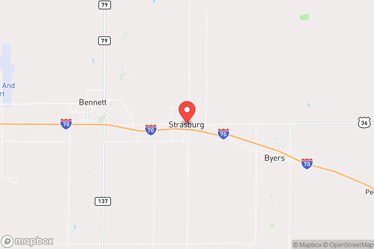
Strasburg, Colorado, sits at a strategic crossroads roughly 30 miles east of Denver along I-70, a position that offers a blend of rural self-sufficiency and access to urban resources—but with trade-offs that demand careful consideration for anyone serious about disaster readiness. This unincorporated community in Adams and Arapahoe counties is not a prepper fantasyland; it’s a working-class plains town where resilience comes from practical geography, a tight-knit population of about 2,500, and proximity to the Front Range’s logistical spine. For a relocator weighing self-sufficiency against exposure to risks, Strasburg presents a mixed but workable profile: strong on water access and defensible space, weaker on isolation from man-made threats tied to Denver’s orbit.
Geographic position and natural advantages for self-sufficiency
Strasburg’s location on the high plains, at an elevation of roughly 5,300 feet, offers several natural advantages for a resilience-minded household. The area sits just south of the South Platte River, a perennial water source that feeds local irrigation and shallow aquifers—a critical asset in a semi-arid region where surface water is scarce. The terrain is flat to gently rolling, with deep, well-drained soils that support dryland wheat farming and, with irrigation, row crops like corn and alfalfa. This agricultural base means local food production is viable: several farms and ranches operate within a 10-mile radius, and the Strasburg Farmers Market (seasonal) provides direct access to produce and meat. The climate is semi-arid, with about 14 inches of annual precipitation, so rainwater catchment is feasible but not a primary water strategy—wells are the norm, and most rural properties have private wells with depths of 100–300 feet. The area’s low population density (roughly 15 people per square mile in the surrounding county) means less competition for resources in a crisis, and the open plains offer excellent defensible space—no dense tree cover to obscure sightlines or fuel wildfires. However, the lack of natural barriers (hills, forests) also means exposure to wind and weather, which can be harsh in winter with blizzards and occasional tornadoes (the area falls in Tornado Alley’s fringe).
Risks, exposures, and proximity to fallout-relevant landmarks
The most significant risk for Strasburg is its proximity to Denver and the Front Range urban corridor, which introduces man-made threats that a remote mountain retreat would avoid. Strasburg is roughly 30 miles from Denver International Airport (DIA), a major transportation hub that could be a target in a conflict or terrorist scenario. The I-70 corridor, which runs through town, is a critical east-west artery for military and commercial logistics; in a national emergency, this road would likely be congested with evacuees and military convoys, making it a liability rather than an asset. Additionally, Strasburg lies about 50 miles from the Rocky Flats National Wildlife Refuge (former nuclear weapons plant) and 60 miles from the U.S. Air Force Academy in Colorado Springs—both potential targets in a large-scale conflict. The area is also within 100 miles of Cheyenne Mountain (NORAD) and Schriever Space Force Base, which could draw secondary effects from a strike on those facilities. Natural risks include severe thunderstorms with large hail (common May–September), occasional tornadoes (EF2 or lower historically), and blizzards that can shut down I-70 for days. The region is seismically stable, with no significant earthquake risk, and wildfire risk is low compared to the foothills west of Denver—the plains lack the dense pine forests that fuel catastrophic fires. Flooding is a minor concern along the South Platte, but Strasburg sits on higher ground above the river’s floodplain.
Practical resilience for a relocator: food, water, energy, and defensibility
For a relocator serious about self-sufficiency, Strasburg offers a workable but not effortless baseline. Water is the strongest asset: the South Platte alluvial aquifer provides reliable groundwater, and most rural properties have private wells with yields of 10–30 gallons per minute—enough for household use and small-scale irrigation. Rainwater catchment is legal in Colorado (since 2016 for well users), but annual precipitation is low, so it’s a supplement, not a primary source. Food production is viable: the growing season runs roughly April to October, with frost-free days averaging 150–160. Soil quality varies but is generally fertile with proper amendment; local extension services (Adams County CSU Extension) offer soil testing and crop advice. Raising livestock (chickens, goats, cattle) is common and legal on parcels of 2 acres or more. The Strasburg area has several feed stores and a local grain elevator, so animal feed is accessible without a long drive. Energy is a mixed picture: the grid is served by Xcel Energy, which has a moderate reliability record (outages from storms are common but usually restored within hours). Solar potential is excellent—the area averages 300+ sunny days per year—and net metering is available, though upfront costs for a residential system (10–15 kW) run $20,000–$35,000 before federal tax credits. Propane is widely used for heating and backup generation; bulk delivery is available from local suppliers like AmeriGas. Defensibility is good: the open terrain provides clear sightlines, and most homes are set back from the road with space for perimeter security. The local sheriff’s office (Adams County) has a substation in Strasburg, but response times in rural areas can be 20–30 minutes. The community is small enough that neighbors know each other, which aids mutual aid in a crisis. The downside is that Strasburg is not a gated or fortified enclave—it’s a working town with a grain elevator, a school, and a few churches, all of which could attract attention in a breakdown scenario.
The overall strategic picture for Strasburg is one of moderate resilience with clear trade-offs. It offers genuine advantages—reliable groundwater, good solar exposure, low population density, and a local agricultural base—that make it a viable choice for a relocator who wants to be within striking distance of Denver’s medical and supply networks but not dependent on them. The risks are real but manageable: proximity to DIA and I-70 means you’re in the blast radius of a major attack on Denver, but the plains’ open geography reduces fallout concentration compared to mountain valleys. For a family or individual willing to invest in a well, solar panels, and a propane backup system, Strasburg can support a high degree of self-sufficiency without the isolation of a remote mountain cabin. The key is to treat it as a base for resilience, not a bunker—plan for 30–90 days of self-reliance, build relationships with neighbors, and keep a vehicle with good ground clearance for winter and post-disaster travel. If you’re looking for a place that balances access with defensibility, Strasburg earns a solid B+—not perfect, but far better than a suburban subdivision or a downtown high-rise.

* Values derived from national, state, county, city and local statistics and may differ in a specific area. Last updated: 2026-09-11T01:16:17.000Z
Narrative content on this page is AI-generated and may contain mistakes. Verify any details that matter before acting on them.
ReloMaps may earn a commission from affiliate links at no extra cost to you.

