Photo: Wikipedia
Strategic Assessment of Rhode Island
Multiple tactical vulnerabilities. Population density, target proximity, or disaster risk are likely compounding. A retreat property and exit planning is required.
What does the Strategic Assessment tell us?
Our Strategic Assessment grades tactical survivability of an area. Major population centers, military targets, fallout zones, natural disasters, and border exposure all drive risk — lower exposure means a more defensible position in a crisis.
This is heavily inspired by Joel Skousen's Strategic Relocation book. Highly recommended you checkout the book ($)What does this tell us?
Our Strategic Assessment grades tactical survivability of an area. Major population centers, military targets, fallout zones, natural disasters, and border exposure all drive risk — lower exposure means a more defensible position in a crisis.
This is heavily inspired by Joel Skousen's Strategic Relocation book. Highly recommended you checkout the book ($)Regional Safe Places
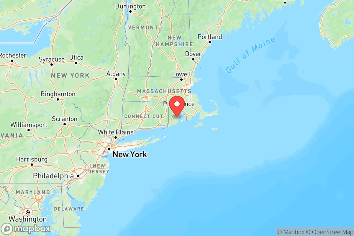
Below is our recommended "safe zones" in Rhode Island and the surrounding area based on our strategic heuristics. For most people, it's unrealistic to live in a “safe zone” full-time due to work, family or other personal reasons. They tend to be more rural. However, many of these areas are perfect for second homes and retreat properties that double as a vacation home or even a short-term rental.


Important Note: For informational purposes only. This does not mean nothing bad ever happens in the green zones. Please use common sense. This is based on public data and modeled with AI. We tried to take a conservative approach but mistakes happen. We update this regularly as new information becomes available.
Solar Generator Recommendations
Backup power matters more here than in safer locations. We've picked three solar generators across budgets and capacity tiers — start with the budget unit if you only need a few essentials, or step up if you want to run a fridge and HVAC for days at a time.

Jackery Portable Power Station Explorer 300
Budget OptionPower on the Go: Weighing only 11 lbs, it's convenient to set up and store with book-sized foldable solar panels

BLUETTI Portable Power Station AC180
Designed for both indoor and outdoor scenarios, AC180 is highly capable as it has a robost capacity and continuous output power.

EF ECOFLOW DELTA Pro Ultra Power Station
Upgraded PickEcoFlow DELTA Pro Ultra is a whole-home energy system designed to grow with your family. Integrated with the Smart Home Panel 2, it scales to meet your evolving energy needs — keeping your home powered, intelligent, and secure through every stage of life.
We earn a commission, at no additional cost to you.
Strategic Assessment Analysis
Rhode Island presents a complex strategic picture for the conservative prepper or relocator. It is a tiny state with outsized exposure to coastal threats and dense urban corridors, yet its position in southern New England offers a unique blend of maritime access, historical infrastructure, and proximity to rural refuges that can be leveraged for resilience. The key is understanding that Rhode Island is not a standalone survival bastion but a potential staging ground or secondary location within a broader Northeast escape plan, provided you choose your specific municipality with extreme care.
Geographic position and natural advantages for a strategic relocation
Rhode Island’s primary strategic asset is its location at the head of Narragansett Bay, offering direct access to the Atlantic Ocean while being sheltered from the worst open-ocean weather. The state’s 400 miles of coastline include deep-water ports like Providence and Quonset Point in North Kingstown, which could become critical for resupply or evacuation if overland routes are compromised. The interior, particularly the western reaches near Foster and Glocester, features rolling hills, dense second-growth forest, and numerous small ponds and reservoirs—terrain that offers natural cover and dispersed water sources. The state’s small size (just 48 miles long and 37 miles wide) means you can theoretically reach any point within an hour, but that same compactness means there is very little buffer from coastal surge or urban spillover. The moderate climate avoids the extreme cold of northern New England, reducing heating fuel demands and allowing for longer growing seasons for subsistence gardening, especially in the southern coastal plain around South Kingstown and Charlestown.
Risks, exposures, and proximity to fallout-relevant landmarks
The downsides are significant and demand honest assessment. Rhode Island is sandwiched between two major population centers: Boston, Massachusetts, 50 miles north, and New York City, 180 miles southwest. In a mass evacuation scenario, I-95 and I-195 would become parking lots, and the state’s small road network would choke quickly. The state itself is densely populated—over 1 million people in 1,200 square miles—meaning rural areas are never truly remote. Providence is a major port and transportation hub, making it a likely target for civil unrest or infrastructure disruption. The Quonset Business Park in North Kingstown houses a deep-water port and industrial facilities, including a major petroleum storage terminal and a large natural gas liquefaction plant—a classic dual-use asset that is both a resource and a target. The Naval Station Newport in Middletown is a high-value military installation that could draw unwanted attention in a conflict scenario. Additionally, the Millstone Nuclear Power Station in Waterford, Connecticut, sits just 30 miles southwest of the Rhode Island border—within the 50-mile ingestion exposure zone. A major incident there would force a rapid evacuation of much of southern Rhode Island. The state’s entire coastline is vulnerable to storm surge from hurricanes, and sea-level rise is already impacting low-lying areas like Warwick and Cranston.
Practical resilience for a relocator: food, water, energy, and defensibility
For the individual or family serious about self-sufficiency, Rhode Island offers a mixed bag. Water is abundant—the state has over 1,000 natural and man-made ponds, plus the Scituate Reservoir (the primary drinking water source for Providence) and numerous smaller watersheds. However, much of this water is in public reservoirs or protected watersheds, so securing legal access for a private well or surface water collection is essential. Food production is feasible in the southern and western rural towns, with decent soil in the coastal plain and a growing season of about 150 days. The state has a small but active farming community, and land prices in places like Exeter or Richmond are lower than in Massachusetts or Connecticut, though still high by national standards. Energy resilience is a weak point: the grid is aging and heavily dependent on natural gas and imported electricity. Solar is viable, but net metering policies are less favorable than in neighboring states. Wood heating is common in rural areas, and a good woodlot on your property is a major asset. Defensibility is the hardest challenge. The state’s small size and dense road network mean there are few natural chokepoints. The best bet is a property set back from main roads, with a long driveway and natural barriers like stone walls or dense forest. The western towns of Foster and Glocester offer the best combination of low population density, forest cover, and distance from major infrastructure targets. Avoid any property within 10 miles of I-95, the port facilities, or the naval base.
The overall strategic picture for a conservative relocator
Rhode Island is not a bug-out destination for the lone wolf prepper. It is a location for the strategic relocator who wants to remain within striking distance of the Northeast’s economic and cultural centers while maintaining a credible fallback position. Think of it as a forward operating base: you can live quietly in the western woods, stock supplies, and develop local networks, but you must have a plan to move deeper into New England (northern New Hampshire or Maine) if the situation deteriorates. The state’s political climate leans heavily blue, which may be a cultural friction point for conservative families, but the rural towns are more libertarian-leaning and generally leave people alone. The key takeaway: choose your town carefully, secure your water and wood supply, and never rely on the state for anything. Rhode Island can work as a long-term home if you treat it as a managed risk—not a sanctuary, but a defensible position with options.
Top 10 Cities by Strategic Assessment in Rhode Island


* Values derived from national, state, county, city and local statistics and may differ in a specific area. Last updated: 2026-04-19T01:38:18.000Z
Narrative content on this page is AI-generated and may contain mistakes. Verify any details that matter before acting on them.
ReloMaps may earn a commission from affiliate links at no extra cost to you.