
Photo: Wikipedia
Strategic Assessment of Port Arthur, TX
Multiple tactical vulnerabilities. Population density, target proximity, or disaster risk are likely compounding. A retreat property and exit planning is required.
What does the Strategic Assessment tell us?
Our Strategic Assessment grades tactical survivability of an area. Major population centers, military targets, fallout zones, natural disasters, and border exposure all drive risk — lower exposure means a more defensible position in a crisis.
This is heavily inspired by Joel Skousen's Strategic Relocation book. Highly recommended you checkout the book ($)What does this tell us?
Our Strategic Assessment grades tactical survivability of an area. Major population centers, military targets, fallout zones, natural disasters, and border exposure all drive risk — lower exposure means a more defensible position in a crisis.
This is heavily inspired by Joel Skousen's Strategic Relocation book. Highly recommended you checkout the book ($)Strategic Pillars

Key Distances
Regional Safe Places
Below is our recommended "safe zones" in Texas and the surrounding area based on our strategic heuristics. For most people, it's unrealistic to live in a “safe zone” full-time due to work, family or other personal reasons. They tend to be more rural. However, many of these areas are perfect for second homes and retreat properties that double as a vacation home or even a short-term rental.


Important Note: For informational purposes only. This does not mean nothing bad ever happens in the green zones. Please use common sense. This is based on public data and modeled with AI. We tried to take a conservative approach but mistakes happen. We update this regularly as new information becomes available.
Solar Generator Recommendations
Backup power matters more here than in safer locations. We've picked three solar generators across budgets and capacity tiers — start with the budget unit if you only need a few essentials, or step up if you want to run a fridge and HVAC for days at a time.

Jackery Portable Power Station Explorer 300
Budget OptionPower on the Go: Weighing only 11 lbs, it's convenient to set up and store with book-sized foldable solar panels

BLUETTI Portable Power Station AC180
Designed for both indoor and outdoor scenarios, AC180 is highly capable as it has a robost capacity and continuous output power.

EF ECOFLOW DELTA Pro Ultra Power Station
Upgraded PickEcoFlow DELTA Pro Ultra is a whole-home energy system designed to grow with your family. Integrated with the Smart Home Panel 2, it scales to meet your evolving energy needs — keeping your home powered, intelligent, and secure through every stage of life.
We earn a commission, at no additional cost to you.
Strategic Assessment Analysis
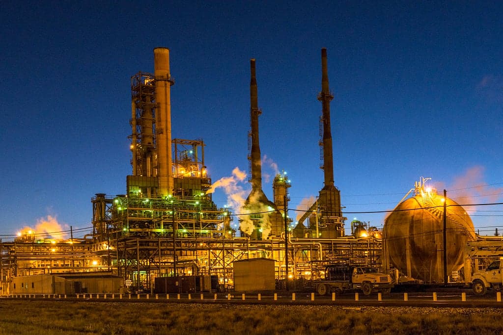
Port Arthur, Texas, offers a mixed strategic picture for the conservative prepper or survivalist. Its primary value lies in its position as a coastal energy hub with deep-water port access and a significant petrochemical infrastructure, but that same industrial density creates a unique set of risks. For a relocator prioritizing self-sufficiency and low-collateral exposure, Port Arthur demands a clear-eyed assessment of its resilience advantages against its very real vulnerabilities to both natural disasters and man-made fallout.
Geographic position and natural advantages for long-term survival
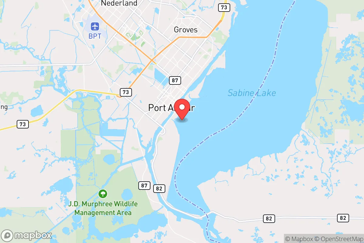
Port Arthur sits at the nexus of the Gulf Coast, the Sabine River, and the Intracoastal Waterway, giving it a logistical advantage that few other small cities can match. The area is flat, marshy, and heavily influenced by the Gulf of Mexico, which means a reliable water table and abundant rainfall—critical for off-grid water collection and small-scale agriculture. The surrounding Jefferson County and neighboring Orange County are sparsely populated relative to Houston, offering a buffer of rural land and bayou country that can serve as a retreat zone. The proximity to the Sabine National Forest and the Big Thicket National Preserve, both within a two-hour drive, provides additional options for hunting, foraging, and long-term wilderness survival. For a relocator willing to invest in a raised home on pilings and a boat for secondary transport, the area's natural waterways become a defensible network rather than a liability. The climate supports year-round growing seasons, which is a major plus for food security, though the humidity and heat require careful planning for food storage and medical supplies.
Risks, exposures, and proximity to fallout-relevant landmarks
The most significant downside to Port Arthur is its concentration of high-value, high-risk industrial targets. The city is home to the Motiva Enterprises refinery, the largest oil refinery in the United States, along with numerous chemical plants, LNG terminals, and storage facilities along the Neches River. In a scenario involving civil unrest, EMP, or state-level collapse, these facilities become prime targets for sabotage, looting, or accidental catastrophe. A major release of hydrogen sulfide or benzene could render large portions of the city uninhabitable for weeks. Additionally, Port Arthur lies directly in the path of hurricane storm surges—Hurricane Harvey in 2017 and Hurricane Laura in 2020 both caused catastrophic flooding. The city's elevation averages just 5 feet above sea level, making it one of the most flood-prone urban areas in Texas. For the prepper, this means any long-term survival plan must include a secondary location at least 30 miles inland, preferably on higher ground near the Beaumont or Lumberton areas. The proximity to the Gulf also raises the risk of a nuclear or radiological incident from a damaged reactor or transport vessel—the nearest nuclear plant, the River Bend Station, is about 60 miles upriver in St. Francisville, Louisiana, but prevailing winds could carry fallout directly over Port Arthur in a worst-case event.
Practical resilience for a relocator: food, water, energy, and defensibility
On the practical side, Port Arthur offers some genuine resilience advantages for a prepared individual. Water is abundant—the Sabine River and the Neches River provide surface water that can be filtered and treated with relative ease, and the high water table means shallow wells can be dug in many areas. Rainwater collection is also highly productive, with the region averaging over 55 inches of rainfall annually. For energy, the area is a natural gas hub, and many rural properties already have propane tanks or natural gas hookups that can be paired with generators or converted to off-grid cooking and heating. Solar is viable but less efficient due to frequent cloud cover from Gulf storms, so a hybrid system with battery storage and a backup generator is recommended. Food security is a mixed bag: local soil is sandy and acidic, requiring raised beds or imported topsoil for vegetable gardening, but the fishing in Sabine Lake and the Gulf is excellent, and wild game like deer, feral hogs, and waterfowl are plentiful in the surrounding marshlands. Defensibility is the weakest point. The flat terrain offers no natural chokepoints or high ground, and the dense network of canals and bayous can be used by adversaries as much as by defenders. A well-chosen property on a dead-end road with a canal on one side and a levee on the other can create a defensible perimeter, but it requires careful scouting. The local population is a mix of long-term residents with deep community ties and transient industrial workers, which means social cohesion is moderate but not as strong as in smaller, more isolated Texas towns. For a single individual or family, building trust with neighbors is essential—this is not a place to go full hermit.
The overall strategic picture for Port Arthur is one of high risk with high potential reward for the prepared relocator. It is not a bug-out location for a weekend warrior; it is a long-term base for someone willing to invest in flood mitigation, industrial hazard awareness, and a robust evacuation plan. The city's economic reliance on petrochemicals means it will be a target in any major disruption, but its water access, energy infrastructure, and proximity to wild areas also make it a viable hub for a decentralized survival network. For the conservative prepper who values industrial capability and maritime access over isolation, Port Arthur offers a gritty, no-nonsense option—but only if you are ready to deal with the Gulf's fury and the refinery's shadow.
* Values derived from national, state, county, city and local statistics and may differ in a specific area. Last updated: 2026-05-14T18:47:59.000Z
Narrative content on this page is AI-generated and may contain mistakes. Verify any details that matter before acting on them.
ReloMaps may earn a commission from affiliate links at no extra cost to you.