
Photo: Wikipedia
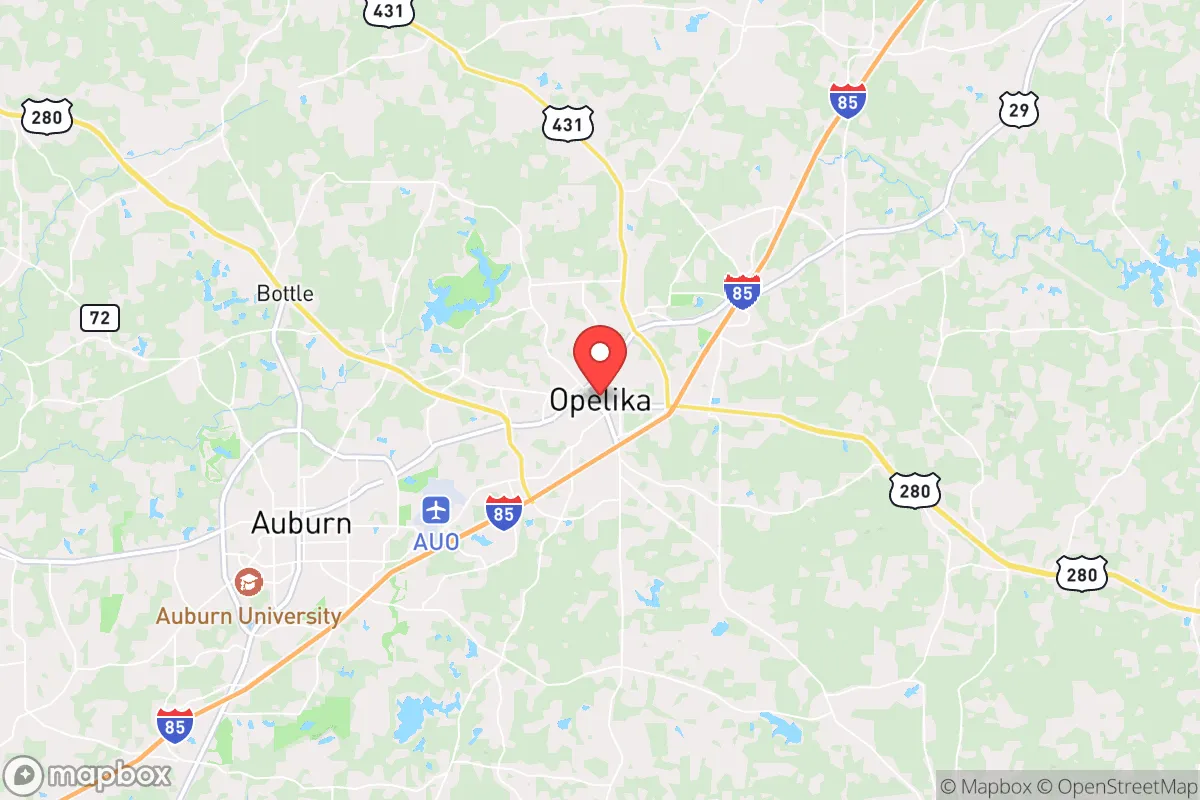
Strategic Assessment of Opelika, AL
Workable tactical position. Some exposure to population density or targets, but generally defensible in a crisis.
What does the Strategic Assessment tell us?
Our Strategic Assessment grades tactical survivability of an area. Major population centers, military targets, fallout zones, natural disasters, and border exposure all drive risk — lower exposure means a more defensible position in a crisis.
This is heavily inspired by Joel Skousen's Strategic Relocation book. Highly recommended you checkout the book ($)What does this tell us?
Our Strategic Assessment grades tactical survivability of an area. Major population centers, military targets, fallout zones, natural disasters, and border exposure all drive risk — lower exposure means a more defensible position in a crisis.
This is heavily inspired by Joel Skousen's Strategic Relocation book. Highly recommended you checkout the book ($)Strategic Pillars

Key Distances
Regional Safe Places
Below is our recommended "safe zones" in Alabama and the surrounding area based on our strategic heuristics. For most people, it's unrealistic to live in a “safe zone” full-time due to work, family or other personal reasons. They tend to be more rural. However, many of these areas are perfect for second homes and retreat properties that double as a vacation home or even a short-term rental.
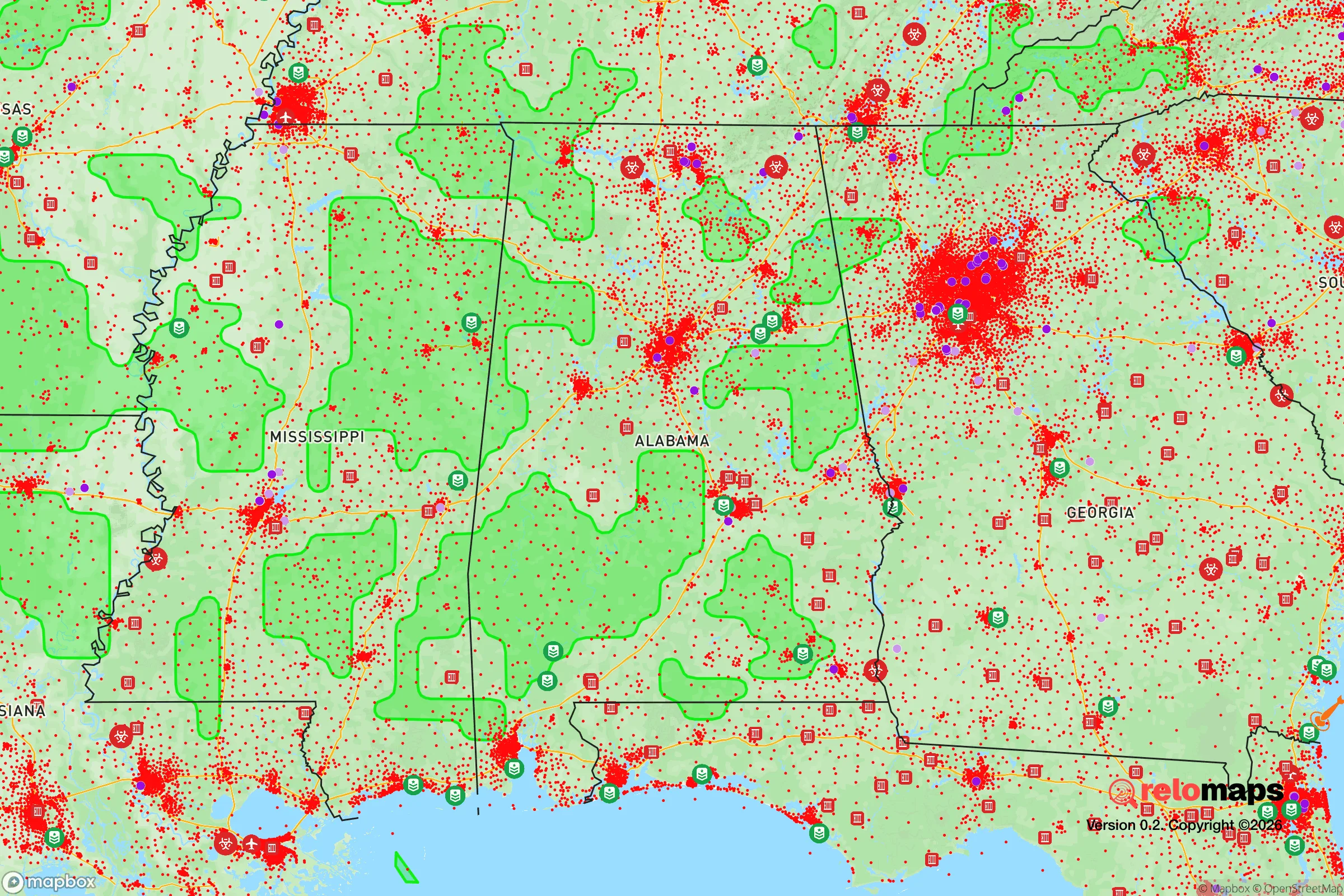
Important Note: For informational purposes only. This does not mean nothing bad ever happens in the green zones. Please use common sense. This is based on public data and modeled with AI. We tried to take a conservative approach but mistakes happen. We update this regularly as new information becomes available.
Solar Generator Recommendations
Backup power matters more here than in safer locations. We've picked three solar generators across budgets and capacity tiers — start with the budget unit if you only need a few essentials, or step up if you want to run a fridge and HVAC for days at a time.

Jackery Portable Power Station Explorer 300
Budget OptionPower on the Go: Weighing only 11 lbs, it's convenient to set up and store with book-sized foldable solar panels

BLUETTI Portable Power Station AC180
Designed for both indoor and outdoor scenarios, AC180 is highly capable as it has a robost capacity and continuous output power.

EF ECOFLOW DELTA Pro Ultra Power Station
Upgraded PickEcoFlow DELTA Pro Ultra is a whole-home energy system designed to grow with your family. Integrated with the Smart Home Panel 2, it scales to meet your evolving energy needs — keeping your home powered, intelligent, and secure through every stage of life.
We earn a commission, at no additional cost to you.
Strategic Assessment Analysis
Opelika, Alabama, offers a compelling strategic position for those prioritizing resilience and long-term preparedness, combining a robust local economy with a location that is close enough to major resources yet sufficiently removed from the highest-risk urban and industrial targets. Situated in east-central Alabama along the I-85 corridor, Opelika forms the eastern half of the Auburn-Opelika metropolitan area, a region that has demonstrated consistent economic growth and population stability even during national downturns. For a relocator concerned with civic unrest, mass casualty events, or supply chain disruptions, Opelika’s mix of manufacturing diversity, access to water, and a politically conservative community provides a foundation that many similarly sized Southern towns cannot match. The city’s resilience is not accidental—it stems from a deliberate industrial base that includes food processing, automotive parts, and advanced manufacturing, which together create a degree of economic self-sufficiency that buffers against external shocks.
Geographic position and natural advantages for long-term security
Opelika sits on the fall line where the Piedmont region meets the Coastal Plain, giving it a topography that is gently rolling rather than flat, which aids drainage and reduces flood risk compared to areas further south. The city is roughly 60 miles northeast of Montgomery and 100 miles southwest of Atlanta—close enough to access major medical centers and supply hubs, but far enough that a major urban crisis in either city would not immediately overwhelm Opelika. The surrounding Lee County is part of the Southern Piedmont, with clay soils that support mixed hardwood-pine forests, providing ample cover and natural resources for those who value privacy and defensibility. The area’s annual rainfall averages around 52 inches, which is above the national average and supports reliable groundwater recharge; the nearby Saugahatchee Creek and the larger Tallapoosa River to the west offer additional water sources that are less likely to be contested than municipal supplies. For a prepper mindset, the absence of major floodplains, hurricane storm surge zones, or earthquake faults within a 50-mile radius reduces the likelihood of natural disaster forcing a relocation. The climate is humid subtropical, with hot summers and mild winters, meaning that cold-weather survival gear is less critical than water management and heat resilience—a practical consideration for long-term stockpiling and infrastructure planning.
Risks, exposures, and proximity to fallout-relevant landmarks
No location is without vulnerabilities, and Opelika’s primary risks stem from its position within the broader Southeastern industrial and transportation network. The city lies within 30 miles of the Joseph M. Farley Nuclear Plant, a two-unit pressurized water reactor near Columbia, Alabama, on the Chattahoochee River. While the plant has a strong safety record, any nuclear facility within 50 miles is a legitimate concern for fallout planning; a major incident would place Opelika in the plume exposure pathway, requiring a pre-planned evacuation route east or southeast away from the prevailing winds. Additionally, I-85 is a major freight corridor connecting Atlanta to Montgomery, and the interstate runs directly through Opelika. In a scenario involving civil unrest or mass casualty events, this highway could become a chokepoint or a vector for displaced populations moving away from Atlanta. The city’s proximity to the Auburn University campus—just 10 miles west—introduces a different kind of risk: a large, transient student population that could become a source of social instability during a crisis, particularly if university operations cease and thousands of young adults are suddenly without housing or purpose. On the positive side, Opelika has no major military bases, chemical plants, or oil refineries within its immediate vicinity, which reduces the likelihood of being a direct target in a conflict scenario. The nearest major military installation is Fort Moore (formerly Fort Benning) in Georgia, about 70 miles southeast, which is far enough to avoid collateral effects from base-related incidents.
Practical resilience for a relocator: food, water, energy, and defensibility
For someone serious about self-sufficiency, Opelika offers several concrete advantages. The city’s water supply comes from the Opelika Water Works Board, which draws from the Saugahatchee Creek and the Tallapoosa River, with a treatment capacity that exceeds current demand. Backup power for the water system is in place, but a relocator should still plan for private well installation if moving to the outskirts—the water table in Lee County is generally accessible at depths of 50 to 150 feet, and the clay soils provide decent filtration. Food resilience is supported by the presence of the Opelika Farmers Market and a growing network of local farms within a 20-mile radius, including several that raise cattle, poultry, and vegetables. The city is also home to a large Tyson Foods poultry processing plant, which means that even in a supply chain disruption, protein sources are locally available. Energy-wise, Opelika is served by Alabama Power, which relies on a mix of coal, natural gas, nuclear, and hydroelectric generation; the grid is generally reliable, but the area experiences occasional summer thunderstorms that can cause localized outages. For defensibility, the terrain around Opelika is a mix of open farmland and wooded hills, with many properties offering natural sightlines and limited road access. The city’s crime rate is below the national average for violent crime, and the community is predominantly conservative and family-oriented, which tends to foster neighborhood watch dynamics and mutual aid networks. Property taxes in Lee County are low—around 0.4% of assessed value—and there are no state income taxes on Social Security benefits, which appeals to retirees and those planning for long-term financial resilience.
The overall strategic picture for Opelika is one of balanced risk and reward. It is not a remote bunker location, nor is it a high-security fortress; rather, it is a functioning small city with a diversified economy, reliable infrastructure, and a population that largely shares the values of self-reliance and community preparedness. The proximity to Auburn University is a double-edged sword—it provides access to medical research and a major hospital (East Alabama Medical Center) but also introduces a volatile element in a crisis. For a relocator who wants to be within a few hours of Atlanta’s resources without being exposed to Atlanta’s risks, Opelika is a strong candidate. The key is to buy property outside the immediate city limits, preferably on a dead-end road with a well and septic, and to build relationships with local farmers and gun clubs before a crisis hits. In a worst-case scenario involving national grid failure or widespread civil unrest, Opelika’s location on the I-85 corridor could become a liability, but its agricultural base and conservative culture give it a better chance of maintaining order than many similarly sized towns. For those willing to put in the work—stockpiling, networking, and hardening a property—Opelika offers a realistic foundation for long-term survival without the isolation of a mountain retreat.
* Values derived from national, state, county, city and local statistics and may differ in a specific area. Last updated: 2026-04-19T19:03:01.000Z
Narrative content on this page is AI-generated and may contain mistakes. Verify any details that matter before acting on them.
ReloMaps may earn a commission from affiliate links at no extra cost to you.