Photo: Wikipedia
Strategic Assessment of Morrisville, VT
Meaningful friction. Expect exposure to either population pressure, blast zones, or natural disaster risk. Consider buying a retreat property.
What does the Strategic Assessment tell us?
Our Strategic Assessment grades tactical survivability of an area. Major population centers, military targets, fallout zones, natural disasters, and border exposure all drive risk — lower exposure means a more defensible position in a crisis.
This is heavily inspired by Joel Skousen's Strategic Relocation book. Highly recommended you checkout the book ($)What does this tell us?
Our Strategic Assessment grades tactical survivability of an area. Major population centers, military targets, fallout zones, natural disasters, and border exposure all drive risk — lower exposure means a more defensible position in a crisis.
This is heavily inspired by Joel Skousen's Strategic Relocation book. Highly recommended you checkout the book ($)Strategic Pillars

Key Distances
Regional Safe Places
Below is our recommended "safe zones" in Vermont and the surrounding area based on our strategic heuristics. For most people, it's unrealistic to live in a “safe zone” full-time due to work, family or other personal reasons. They tend to be more rural. However, many of these areas are perfect for second homes and retreat properties that double as a vacation home or even a short-term rental.


Important Note: For informational purposes only. This does not mean nothing bad ever happens in the green zones. Please use common sense. This is based on public data and modeled with AI. We tried to take a conservative approach but mistakes happen. We update this regularly as new information becomes available.
Solar Generator Recommendations
Backup power matters more here than in safer locations. We've picked three solar generators across budgets and capacity tiers — start with the budget unit if you only need a few essentials, or step up if you want to run a fridge and HVAC for days at a time.

Jackery Portable Power Station Explorer 300
Budget OptionPower on the Go: Weighing only 11 lbs, it's convenient to set up and store with book-sized foldable solar panels

BLUETTI Portable Power Station AC180
Designed for both indoor and outdoor scenarios, AC180 is highly capable as it has a robost capacity and continuous output power.

EF ECOFLOW DELTA Pro Ultra Power Station
Upgraded PickEcoFlow DELTA Pro Ultra is a whole-home energy system designed to grow with your family. Integrated with the Smart Home Panel 2, it scales to meet your evolving energy needs — keeping your home powered, intelligent, and secure through every stage of life.
We earn a commission, at no additional cost to you.
Strategic Assessment Analysis
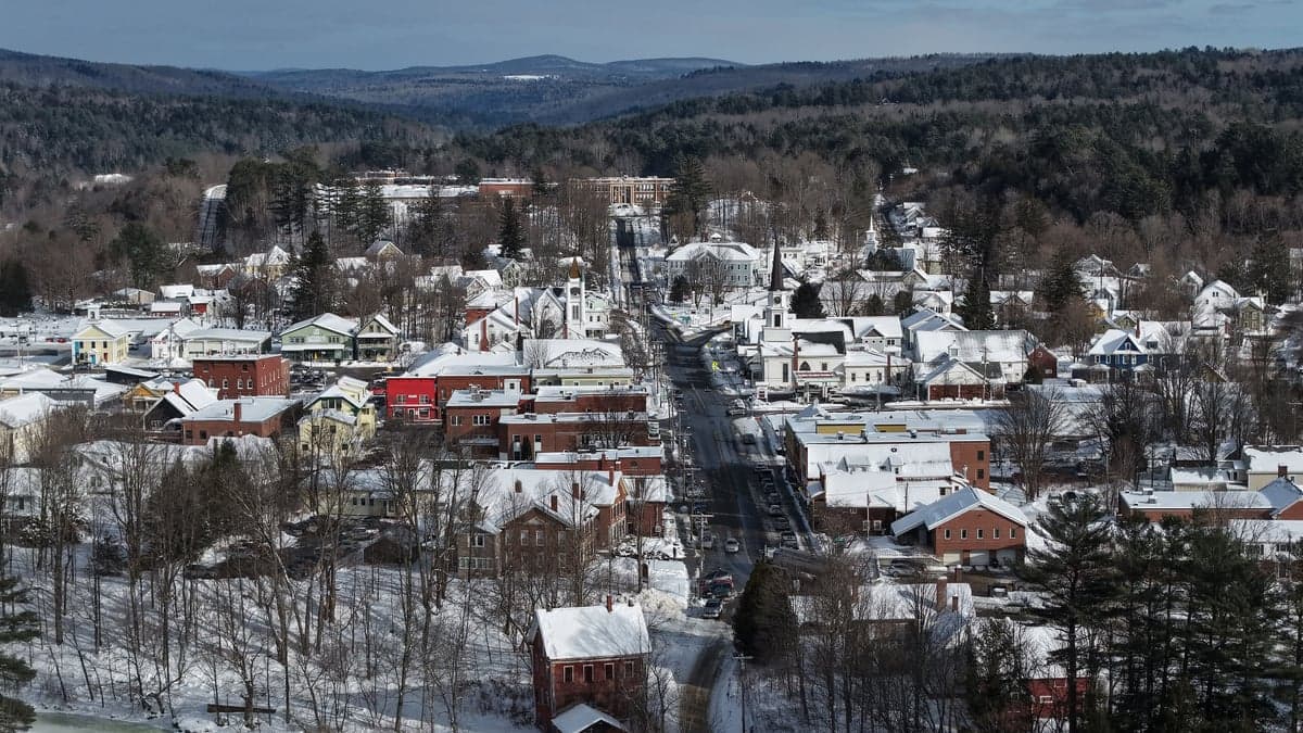
Morrisville, Vermont, offers a surprisingly resilient strategic position for those prioritizing self-sufficiency and distance from major population centers, though it is not without its own set of vulnerabilities. Tucked into Lamoille County in the northern Green Mountains, this town of roughly 2,000 people sits far enough from the Boston-to-Washington corridor to avoid the immediate fallout of a major urban crisis, yet it remains connected enough for resupply and communication. For a relocator with a prepper mindset, the key trade-off here is between the area's natural defensibility and its exposure to specific risks tied to its geography and regional infrastructure.
Geographic position and natural advantages for long-term security
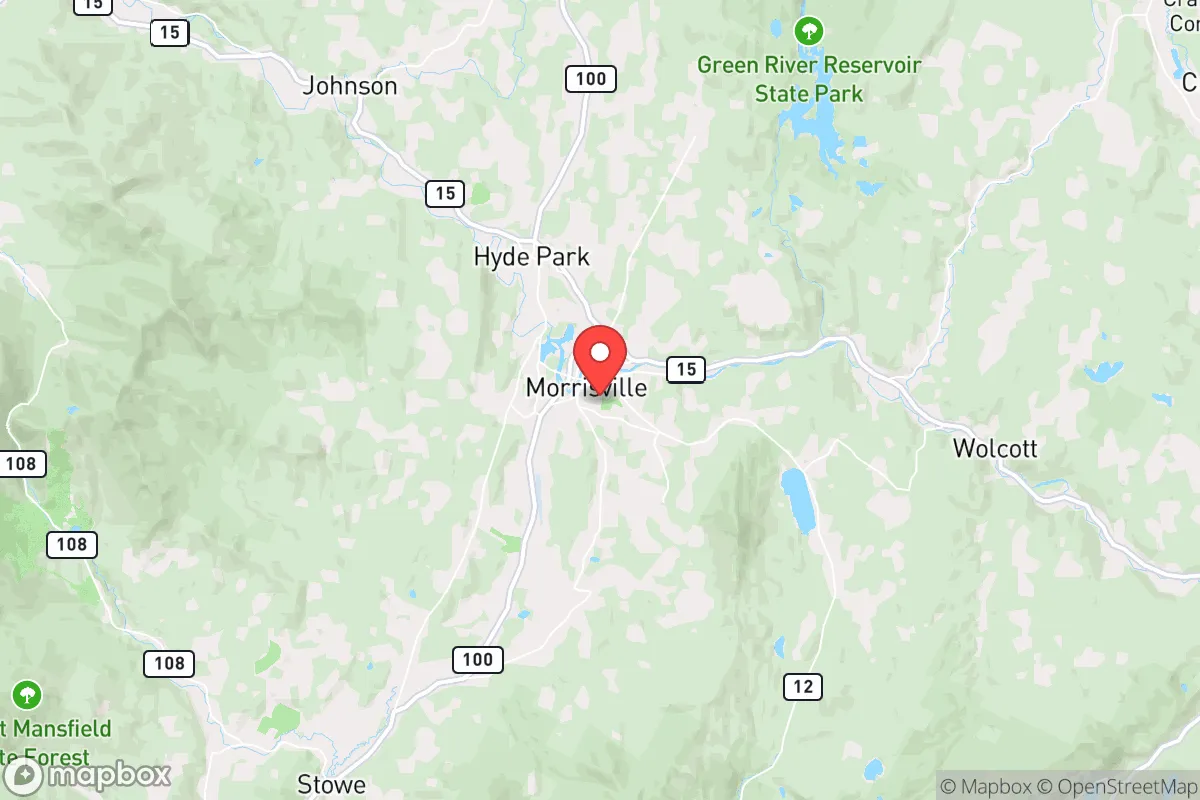
Morrisville's location is defined by the Lamoille River Valley, which provides a natural corridor through the mountains while still offering significant terrain-based isolation. The town sits at the junction of Vermont Routes 15 and 100, giving you two viable egress routes if one becomes compromised—a critical factor for any strategic relocation. The surrounding Green Mountains create a natural barrier that slows movement and limits visibility, which is a tactical advantage for those concerned about civil unrest or mass casualty events spilling out of larger cities. The area's elevation (roughly 700 feet) and northern latitude mean cooler summers and harsh winters, but that same climate discourages casual transient traffic and reduces the risk of vector-borne diseases that plague warmer regions. Water is abundant: the Lamoille River runs through town, and numerous smaller streams and springs dot the surrounding hillsides, making independent water sourcing feasible with proper filtration. The soils in the valley are workable for small-scale agriculture, though the growing season is short (roughly 100-120 frost-free days), so you'll need to plan for cold-hardy crops and season extension techniques.
Risks, exposures, and proximity to fallout-relevant landmarks
No location is a fortress, and Morrisville has specific vulnerabilities that a serious relocator must account for. The most immediate concern is the proximity to the Burlington-South Burlington metropolitan area, about 35 miles to the west. While that distance provides a buffer, Burlington is the largest population center in northern New England (roughly 45,000 in the city proper, over 200,000 in the metro) and would be a primary target for any coordinated disruption—whether from civil unrest, a major infrastructure failure, or a mass casualty event. The Interstate 89 corridor, which runs from the Canadian border through Burlington down to the Massachusetts line, is a major north-south artery that could become a chokepoint or a vector for movement during a crisis. Morrisville is about 15 miles east of I-89, close enough to feel secondary effects but far enough to avoid direct exposure. Another concern is the proximity to the Vermont Yankee nuclear site in Vernon (about 100 miles south), which is in decommissioning but still contains spent fuel. A catastrophic event there could send fallout up the Connecticut River Valley, though prevailing winds typically carry it eastward, away from Morrisville. More immediately, the town itself is vulnerable to winter storms and ice events that can knock out power for days or weeks—a recurring risk that demands robust backup systems. Flooding along the Lamoille River is a periodic hazard, with major events in 2011 (Tropical Storm Irene) and 2023 causing significant damage to low-lying areas. Any property you consider should be above the 100-year floodplain.
Practical resilience for a relocator: food, water, energy, and defensibility
For someone serious about self-reliance, Morrisville offers a mixed but workable picture. Food security is achievable but requires effort. The local agricultural scene is dominated by dairy and hay, but there is a growing network of small-scale vegetable farms, CSAs, and farmers' markets (the Morrisville Farmers Market runs May through October). You can supplement with hunting—white-tailed deer are abundant, and the area has a healthy black bear population—and fishing in the Lamoille River and nearby lakes like Elmore and Green River Reservoir. For long-term storage, the town has a Hannaford supermarket and a couple of smaller grocers, but supply chains here are thin; a regional disruption would empty shelves quickly. Water is less of a concern: the Lamoille River is reliable year-round, and many properties have access to springs or shallow wells. A good Berkey or similar gravity filter, plus a UV sterilizer, will handle most threats. Energy independence is the harder nut to crack. The grid is rural and prone to outages; solar is viable but requires battery storage to handle the long, cloudy winters. Wood heat is the standard backup here—most homes have a wood stove or fireplace, and firewood is plentiful if you have the land and labor to process it. Defensibility is decent but not fortress-grade. The terrain provides natural chokepoints on the roads leading into town, but the valley floor is open enough that a determined group could approach from multiple directions. The local population is small and generally self-reliant, which reduces the risk of looting or organized crime that plagues urban areas during breakdowns. However, the town's position as a regional hub for the surrounding rural areas means it could become a gathering point for displaced people if a crisis hits the broader region. You'll want a property with good sightlines and a secondary water source, ideally off the main roads.
The overall strategic picture for Morrisville is one of calculated trade-offs. It offers genuine advantages in terms of natural isolation, water abundance, and a climate that discourages casual migration. The risks are real but manageable with proper planning: the proximity to Burlington and I-89 is a concern, but not a dealbreaker if you have a solid bug-in plan and multiple layers of security. The short growing season and winter severity demand serious preparation in food storage and heating, but those are solvable problems with the right infrastructure. For a conservative-leaning relocator who values community self-reliance, low population density, and a culture that still respects personal responsibility, Morrisville is a viable option—provided you go in with eyes open and a plan for the specific challenges this mountain valley presents. It's not a bug-out location for the unprepared, but for those willing to put in the work, it offers a defensible, sustainable base in a region that remains one of the most resilient in the Northeast.
* Values derived from national, state, county, city and local statistics and may differ in a specific area. Last updated: 2026-04-23T11:42:46.000Z
Narrative content on this page is AI-generated and may contain mistakes. Verify any details that matter before acting on them.
ReloMaps may earn a commission from affiliate links at no extra cost to you.