Photo: Wikipedia
Strategic Assessment of Richland County
Strong survivability profile. Good buffer from population centers, with manageable environmental and tactical risks.
What does the Strategic Assessment tell us?
Our Strategic Assessment grades tactical survivability of an area. Major population centers, military targets, fallout zones, natural disasters, and border exposure all drive risk — lower exposure means a more defensible position in a crisis.
This is heavily inspired by Joel Skousen's Strategic Relocation book. Highly recommended you checkout the book ($)What does this tell us?
Our Strategic Assessment grades tactical survivability of an area. Major population centers, military targets, fallout zones, natural disasters, and border exposure all drive risk — lower exposure means a more defensible position in a crisis.
This is heavily inspired by Joel Skousen's Strategic Relocation book. Highly recommended you checkout the book ($)Strategic Pillars

Key Distances
Strategic Assessment Analysis
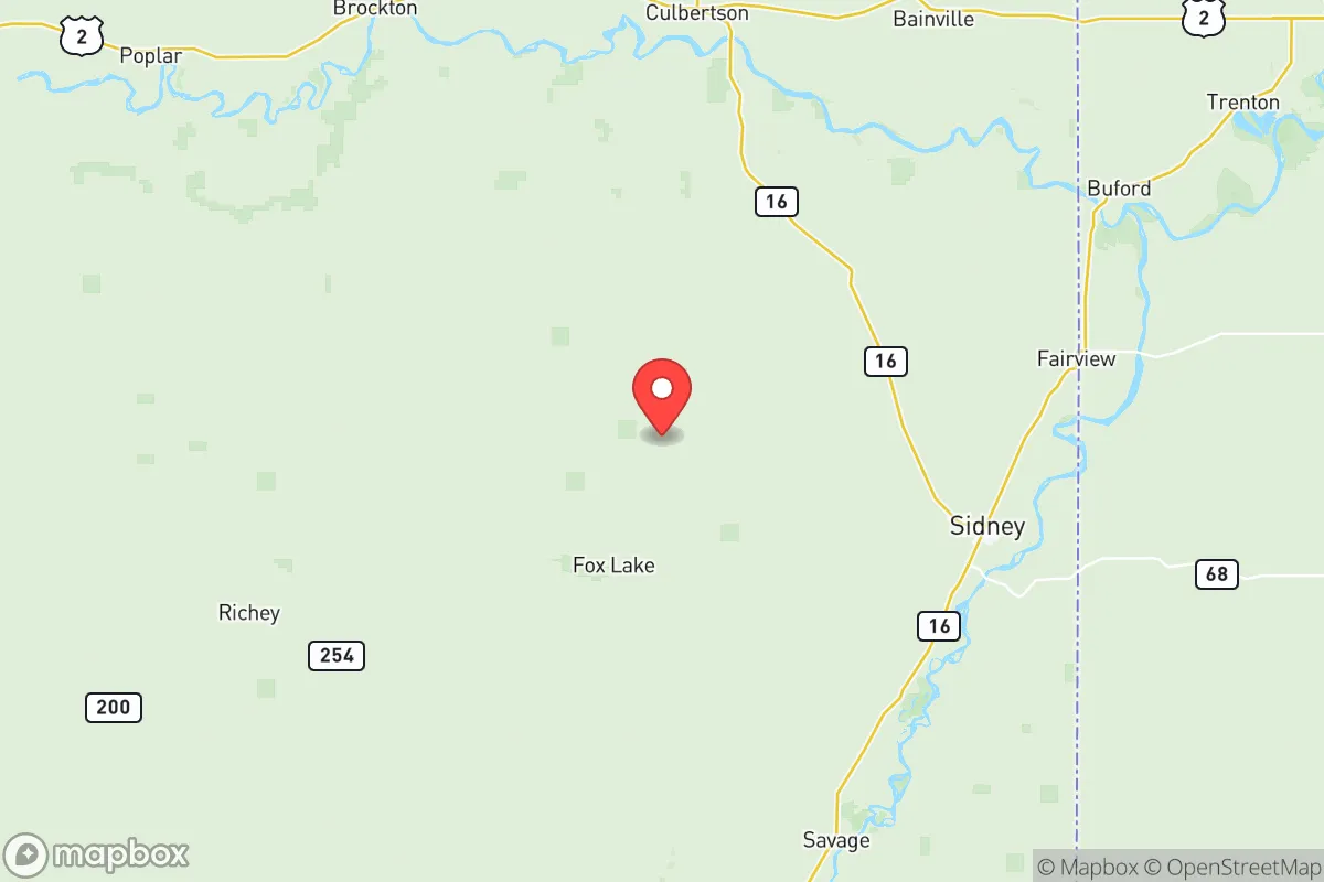
Richland County, Montana, offers a strategic relocation option for those prioritizing resilience and self-sufficiency, combining a remote, low-density population with access to the Yellowstone River and proximity to the Bakken oil fields. The county seat, Sidney, sits roughly 25 miles from the North Dakota border, placing it far from major metropolitan targets like Minneapolis or Seattle, yet within a region that has its own industrial and energy infrastructure. For a reader serious about disaster readiness, Richland County’s combination of agricultural capacity, energy resources, and geographic isolation presents a compelling, if nuanced, case.
Geographic position and natural advantages for long-term security
Richland County’s primary strategic asset is its location in the far eastern part of Montana, a state already known for low population density and minimal strategic value in a conflict scenario. The county spans roughly 2,100 square miles but holds fewer than 12,000 residents, with Sidney as the only incorporated town of note. The Yellowstone River, which flows through the county, provides a reliable freshwater source for irrigation, livestock, and household use—a critical advantage in any prolonged disruption. The surrounding terrain is mostly flat to gently rolling prairie, offering long sightlines and limited cover for potential threats, which aids in defensibility. The county’s distance from major interstate highways (I-94 runs about 60 miles north) and its lack of major rail hubs reduce the likelihood of being a transit corridor for displaced populations or military movements. The Bakken oil fields, while a nearby economic driver, also mean the area has a pre-existing network of energy extraction and distribution, including natural gas processing plants near Sidney and Fairview, which could be leveraged for local energy needs.
Risks, exposures, and proximity to fallout-relevant landmarks
Richland County is not without its vulnerabilities, particularly due to its proximity to energy infrastructure that could become a target or a source of secondary hazards. The most notable risk is the Bakken oil fields, which stretch into the county and include numerous wellheads, pipelines, and gas processing facilities near Sidney and the smaller community of Fairview. While these are not primary strategic targets like a nuclear power plant or major military base, a coordinated attack on energy infrastructure could cause localized contamination or disruption. The county is also roughly 150 miles from Minot Air Force Base in North Dakota, home to nuclear-capable B-52 bombers and missile silos—a high-value target that could generate significant fallout patterns depending on wind direction. The Fort Peck Dam, about 80 miles west, is a large hydroelectric facility that, if compromised, could cause downstream flooding along the Missouri River, though Richland County sits on the Yellowstone, not the Missouri. Natural risks include severe winter storms, tornadoes (though less frequent than in the Plains), and occasional drought, which can stress local agriculture. The county’s low population density and lack of major industrial targets beyond oil infrastructure reduce its attractiveness as a direct target, but the fallout risk from Minot or from a broader conflict involving the Bakken fields is a real consideration.
Practical resilience for a relocator: food, water, energy, and defensibility
For a relocator focused on self-sufficiency, Richland County offers strong fundamentals but requires deliberate preparation. Water access is excellent: the Yellowstone River runs through the county, and groundwater is generally abundant, though well drilling costs vary. The county’s agricultural base—primarily wheat, corn, and cattle—means local food production is viable, and Sidney’s position as a regional trade hub provides access to farm supplies and equipment. Energy is a standout advantage: the Bakken fields mean natural gas and oil are locally available, and many rural properties already use propane or heating oil. Solar potential is good, with over 200 sunny days per year, though winter generation drops significantly. Defensibility is aided by the open terrain and low population density—a small group could monitor approaches from miles away. However, the county’s remoteness also means emergency services are thin: Sidney has a small hospital and volunteer fire departments, but serious medical emergencies require airlift to Billings (about 250 miles west) or Williston, ND (40 miles east). Law enforcement presence is minimal outside Sidney, so personal security and community networks are essential. The county’s culture leans conservative and self-reliant, which aligns with the priorities of a preparedness-minded relocator, but newcomers should expect to invest in their own infrastructure—generators, water storage, and food preservation systems—rather than relying on public utilities.
Overall, Richland County presents a balanced strategic picture for the serious relocator. Its strengths—abundant water, local energy production, low population density, and agricultural capacity—are offset by its proximity to the Bakken oil infrastructure and the fallout risk from Minot Air Force Base. The county is not a fortress, but it offers a viable base for a self-sufficient lifestyle if you are willing to accept the trade-offs of extreme remoteness and limited services. For a family or individual who values independence and is prepared to invest in their own resilience systems, Richland County is a solid, if not perfect, choice in the northern Plains.
* Values derived from national, state, county, city and local statistics and may differ in a specific area. Last updated: 2026-06-11T18:56:10.000Z
Narrative content on this page is AI-generated and may contain mistakes. Verify any details that matter before acting on them.
ReloMaps may earn a commission from affiliate links at no extra cost to you.