
Photo: Wikipedia
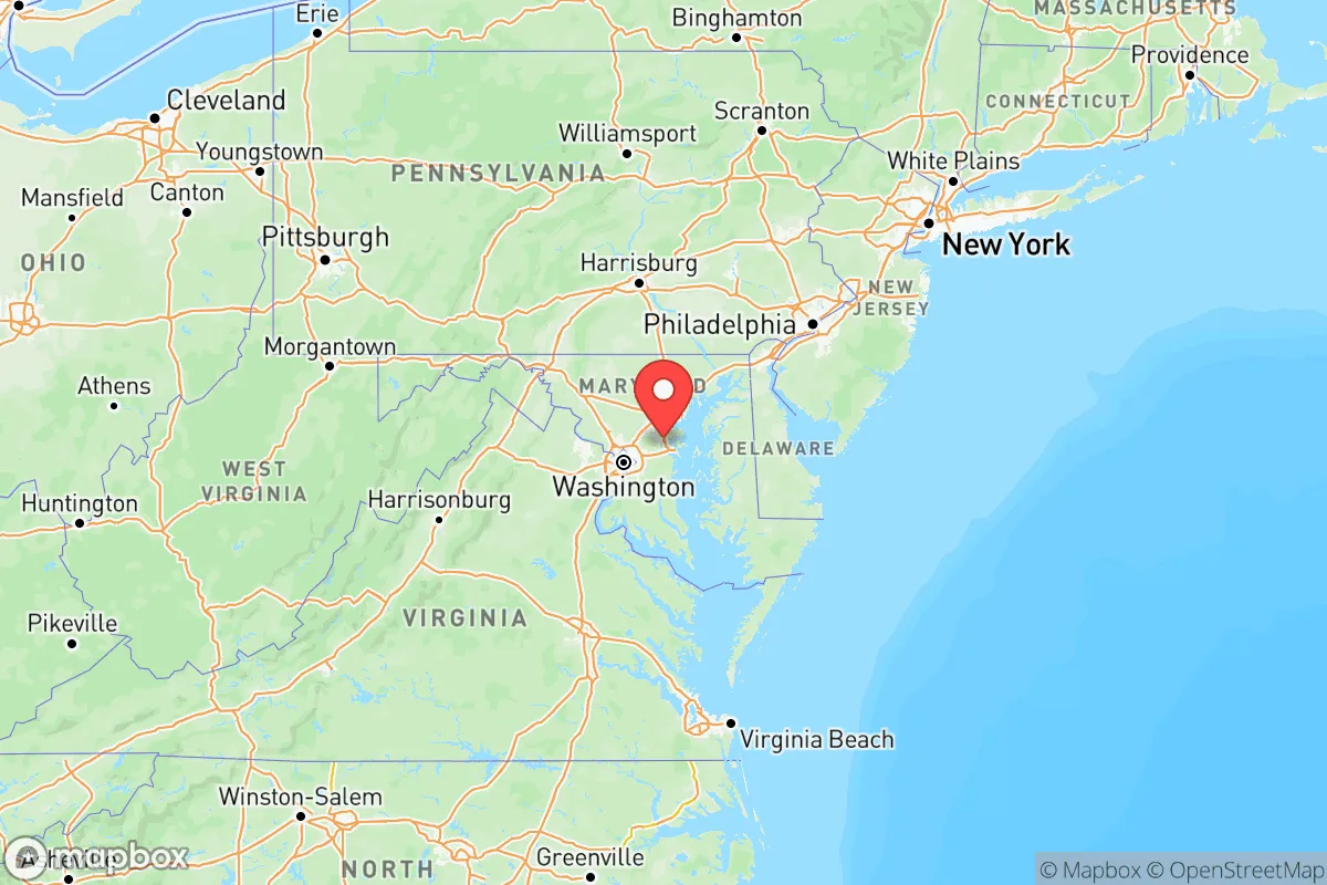
Strategic Assessment of Maryland
Multiple tactical vulnerabilities. Population density, target proximity, or disaster risk are likely compounding. A retreat property and exit planning is required.
What does the Strategic Assessment tell us?
Our Strategic Assessment grades tactical survivability of an area. Major population centers, military targets, fallout zones, natural disasters, and border exposure all drive risk — lower exposure means a more defensible position in a crisis.
This is heavily inspired by Joel Skousen's Strategic Relocation book. Highly recommended you checkout the book ($)What does this tell us?
Our Strategic Assessment grades tactical survivability of an area. Major population centers, military targets, fallout zones, natural disasters, and border exposure all drive risk — lower exposure means a more defensible position in a crisis.
This is heavily inspired by Joel Skousen's Strategic Relocation book. Highly recommended you checkout the book ($)Regional Safe Places
Below is our recommended "safe zones" in Maryland and the surrounding area based on our strategic heuristics. For most people, it's unrealistic to live in a “safe zone” full-time due to work, family or other personal reasons. They tend to be more rural. However, many of these areas are perfect for second homes and retreat properties that double as a vacation home or even a short-term rental.


Important Note: For informational purposes only. This does not mean nothing bad ever happens in the green zones. Please use common sense. This is based on public data and modeled with AI. We tried to take a conservative approach but mistakes happen. We update this regularly as new information becomes available.
Solar Generator Recommendations
Backup power matters more here than in safer locations. We've picked three solar generators across budgets and capacity tiers — start with the budget unit if you only need a few essentials, or step up if you want to run a fridge and HVAC for days at a time.

Jackery Portable Power Station Explorer 300
Budget OptionPower on the Go: Weighing only 11 lbs, it's convenient to set up and store with book-sized foldable solar panels

BLUETTI Portable Power Station AC180
Designed for both indoor and outdoor scenarios, AC180 is highly capable as it has a robost capacity and continuous output power.

EF ECOFLOW DELTA Pro Ultra Power Station
Upgraded PickEcoFlow DELTA Pro Ultra is a whole-home energy system designed to grow with your family. Integrated with the Smart Home Panel 2, it scales to meet your evolving energy needs — keeping your home powered, intelligent, and secure through every stage of life.
We earn a commission, at no additional cost to you.
Strategic Assessment Analysis
Maryland presents a complex strategic picture for conservative relocators seeking resilience: it offers genuine geographic buffers and institutional stability, but its proximity to the nation's capital and critical infrastructure creates severe fallout and unrest risks. The state's position along the Mid-Atlantic coast provides access to the Chesapeake Bay and Atlantic Ocean for maritime escape routes, while the Appalachian Mountains in the west offer rugged terrain for retreat. However, the concentration of federal government, military installations, and industrial targets—from the Aberdeen Proving Ground to the Port of Baltimore—means that any major disruption would ripple through the entire state. For those prioritizing self-sufficiency and low exposure to cascading failures, Maryland demands careful site selection and a clear-eyed assessment of its vulnerabilities.
Geographic position and natural advantages for long-term survival
Maryland's geography is a double-edged sword. The western panhandle, including towns like Cumberland and Hancock, sits in the Appalachian Ridge-and-Valley region, offering defensible terrain, abundant freshwater from the Potomac and Youghiogheny rivers, and lower population density. This area is a strong candidate for a retreat location, with forested hills that provide cover and hunting opportunities. The Eastern Shore, including Salisbury and Easton, is flat and agricultural, with rich soil for farming and access to the Chesapeake Bay for fishing and water transport. The central corridor—from Baltimore to Washington, D.C.—is a high-risk zone due to population density and infrastructure, but it also contains the Fort Meade military complex and NSA headquarters, which would be a primary target in any conflict. The state's moderate climate supports year-round agriculture, with a growing season of 180-200 days in most areas, and ample rainfall averaging 40-45 inches annually reduces reliance on irrigation. For a relocator, the western mountains and Eastern Shore offer the best natural buffers, but both require significant preparation for self-sufficiency.
Risks, exposures, and proximity to fallout-relevant landmarks
Maryland's strategic importance makes it a high-priority target in any national emergency. The Port of Baltimore is one of the busiest on the East Coast, handling coal, salt, and automobiles—its destruction would cripple supply chains. The Baltimore-Washington International Airport (BWI) and Joint Base Andrews (home to Air Force One) are obvious military and transport hubs. The Calvert Cliffs Nuclear Power Plant in Lusby, on the Chesapeake Bay, is a potential radiological hazard; a meltdown or attack could contaminate the bay and surrounding farmland for decades. The Patuxtent River Naval Air Station in St. Mary's County and the Aberdeen Proving Ground in Harford County are active military testing and storage sites, including chemical weapons research. Proximity to Washington, D.C., means that any civil unrest or mass casualty event in the capital—whether from political collapse, terrorism, or foreign attack—would spill into Maryland's suburbs within hours. The I-95 corridor, which runs through the state, would become a chokepoint for refugees fleeing the D.C. metro area. For a conservative prepper, living within 20 miles of any of these landmarks is a significant liability; the safest zones are at least 50 miles from D.C. and Baltimore, in the western panhandle or lower Eastern Shore.
Practical resilience for a relocator: food, water, energy, and defensibility
Maryland's practical resilience varies sharply by region. In the west, Cumberland and Oakland (Garrett County) offer strong defensibility: mountainous terrain, limited road access (only I-68 and US-220), and abundant surface water from the Potomac and Savage River. The area has a history of coal mining, meaning some locals have off-grid energy skills, but modern infrastructure is sparse—cell service is spotty, and natural gas pipelines are limited. The Eastern Shore, around Cambridge and Princess Anne, is flat and open, making it harder to defend but excellent for agriculture: the soil is rich for row crops like corn and soybeans, and the Chesapeake Bay provides seafood. However, the region is vulnerable to storm surge from hurricanes and nor'easters, and the water table is high, complicating well drilling. For energy, solar is viable statewide, but western Maryland has better wind potential on ridgelines. Rainwater collection is straightforward, but filtration is essential due to agricultural runoff and industrial pollution in the bay watershed. Defensible properties in Maryland are rare and expensive: a 10-acre parcel in Garrett County with a well and septic can cost $150,000-$300,000, while similar land on the Eastern Shore runs $200,000-$400,000. The state's building codes are moderate, but floodplain restrictions in coastal areas can limit construction. For a relocator, the key is to secure a property with a reliable water source (spring or deep well), a backup power system (solar + generator), and a location off main highways to avoid refugee flows.
The overall strategic picture for Maryland is one of calculated risk. The state offers genuine advantages—temperate climate, diverse geography, and access to both ocean and mountains—but these are offset by its role as a national security hub. For a conservative relocator, the western panhandle is the most viable option, providing a buffer from the D.C.-Baltimore axis while still being within a day's drive of essential supplies. The Eastern Shore is a secondary choice for those prioritizing agriculture, but it requires accepting coastal hazards and lower defensibility. The central corridor is a no-go for anyone serious about resilience. Maryland's political climate is increasingly progressive, with strict gun laws (including a handgun permit requirement and an assault weapons ban) and high taxes (state income tax up to 5.75%, property taxes averaging 1.1% of home value), which may deter some conservatives. However, for those willing to navigate these challenges, the state's natural resources and strategic position can support a long-term survival plan—provided you choose your location with the same care you'd use to pick a bug-out route. The bottom line: Maryland is a mixed bag, but with the right property and preparation, it can work as a retreat for those who value proximity to the coast and mountains over absolute safety from fallout.
Top 10 Cities by Strategic Assessment in Maryland


* Values derived from national, state, county, city and local statistics and may differ in a specific area. Last updated: 2026-04-18T22:47:10.000Z
Narrative content on this page is AI-generated and may contain mistakes. Verify any details that matter before acting on them.
ReloMaps may earn a commission from affiliate links at no extra cost to you.