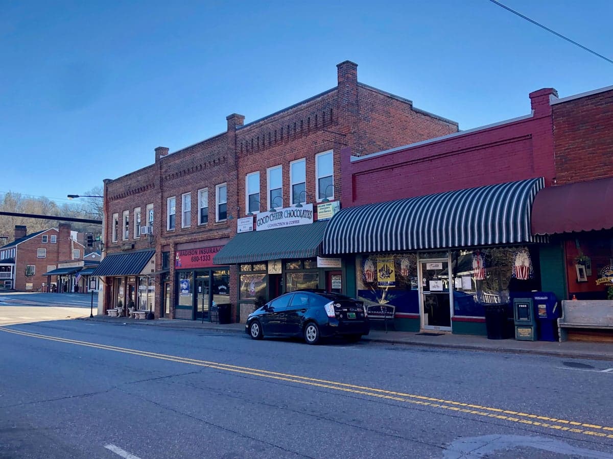
Photo: Wikipedia
Strategic Assessment of Mars Hill, NC
Workable tactical position. Some exposure to population density or targets, but generally defensible in a crisis.
What does the Strategic Assessment tell us?
Our Strategic Assessment grades tactical survivability of an area. Major population centers, military targets, fallout zones, natural disasters, and border exposure all drive risk — lower exposure means a more defensible position in a crisis.
This is heavily inspired by Joel Skousen's Strategic Relocation book. Highly recommended you checkout the book ($)What does this tell us?
Our Strategic Assessment grades tactical survivability of an area. Major population centers, military targets, fallout zones, natural disasters, and border exposure all drive risk — lower exposure means a more defensible position in a crisis.
This is heavily inspired by Joel Skousen's Strategic Relocation book. Highly recommended you checkout the book ($)Strategic Pillars

Key Distances
Regional Safe Places
Below is our recommended "safe zones" in North Carolina and the surrounding area based on our strategic heuristics. For most people, it's unrealistic to live in a “safe zone” full-time due to work, family or other personal reasons. They tend to be more rural. However, many of these areas are perfect for second homes and retreat properties that double as a vacation home or even a short-term rental.

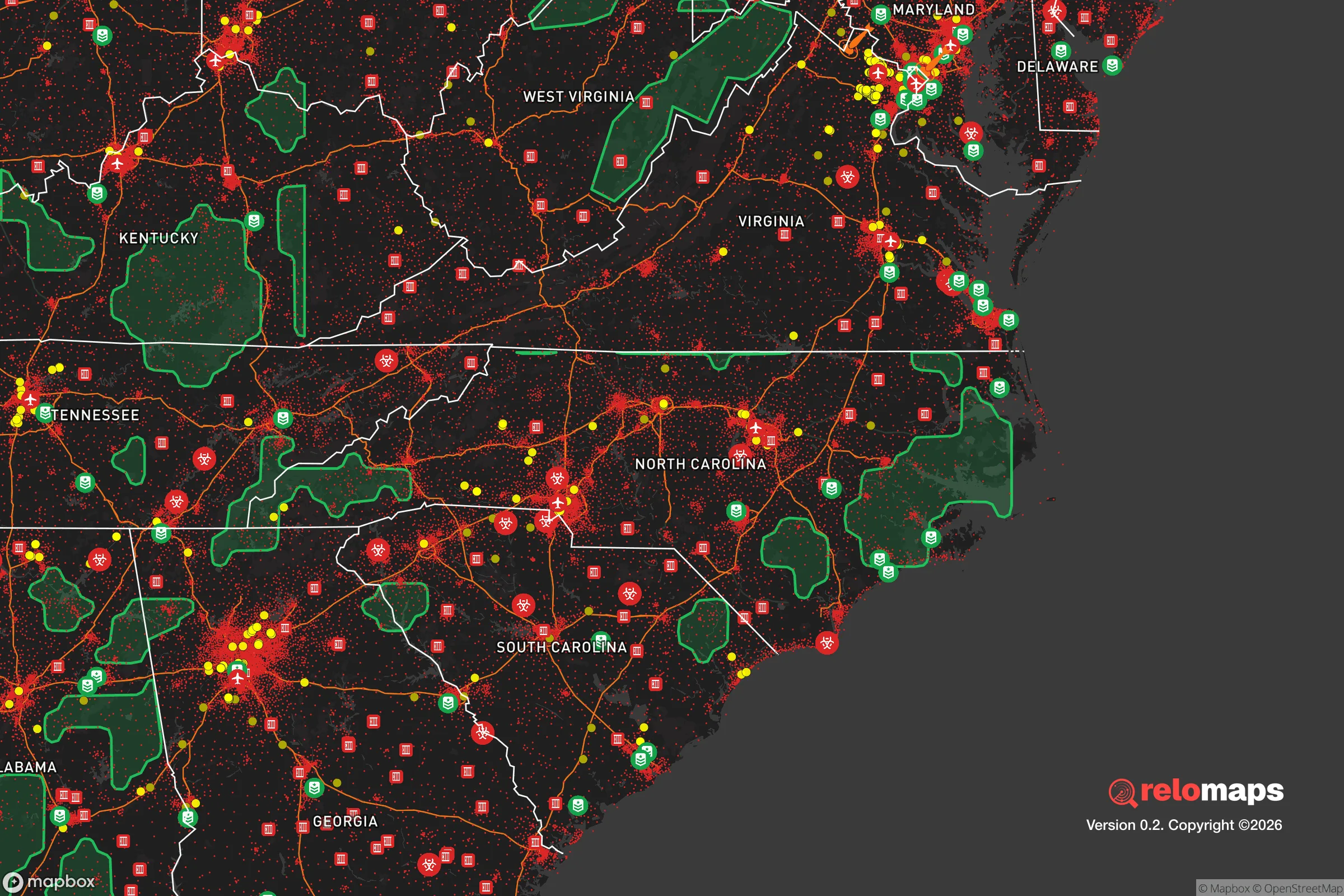


Important Note: For informational purposes only. This does not mean nothing bad ever happens in the green zones. Please use common sense. This is based on public data and modeled with AI. We tried to take a conservative approach but mistakes happen. We update this regularly as new information becomes available.
Solar Generator Recommendations
Backup power matters more here than in safer locations. We've picked three solar generators across budgets and capacity tiers — start with the budget unit if you only need a few essentials, or step up if you want to run a fridge and HVAC for days at a time.

Jackery Portable Power Station Explorer 300
Budget OptionPower on the Go: Weighing only 11 lbs, it's convenient to set up and store with book-sized foldable solar panels

BLUETTI Portable Power Station AC180
Designed for both indoor and outdoor scenarios, AC180 is highly capable as it has a robost capacity and continuous output power.

EF ECOFLOW DELTA Pro Ultra Power Station
Upgraded PickEcoFlow DELTA Pro Ultra is a whole-home energy system designed to grow with your family. Integrated with the Smart Home Panel 2, it scales to meet your evolving energy needs — keeping your home powered, intelligent, and secure through every stage of life.
We earn a commission, at no additional cost to you.
Strategic Assessment Analysis
Mars Hill, North Carolina, offers a compelling balance of mountain seclusion and practical access, making it a noteworthy option for those prioritizing resilience and self-sufficiency. Nestled in Madison County at the edge of the Pisgah National Forest, this small town of roughly 2,500 residents sits about 20 miles north of Asheville, placing it far enough from major urban centers to avoid their worst-case-scenario fallout risks, yet close enough for supply runs or medical care. Its position in the Southern Appalachians provides natural defensive terrain, a temperate climate with reliable rainfall, and a community that has historically weathered economic shifts with a stubborn, independent streak.
Geographic position and natural advantages for self-sufficiency
Mars Hill’s geography is its strongest asset for a resilience-minded relocator. The town sits in a valley along the Ivy River, surrounded by ridges that rise to over 4,000 feet in the nearby Pisgah National Forest and Appalachian Trail corridor. This topography creates natural choke points—only a handful of two-lane roads lead into the area, primarily US-23/NC-74 (a four-lane highway) and smaller county routes like NC-213 and NC-212. In a grid-down scenario, these limited access points make the area inherently defensible; a single downed tree or strategic roadblock can effectively seal off the valley. The elevation, around 2,200 feet, keeps summers mild (average highs in the low 80s) and winters cold enough to suppress many pests, but not so harsh as to make off-grid living impossible. The surrounding national forest offers a buffer of public land that limits dense development and provides a potential resource for timber, game, and foraging, though legal restrictions on harvesting apply. Critically, the region sits in a temperate rainforest zone, receiving 40-50 inches of rain annually, which supports consistent water availability through springs, creeks, and the Ivy River itself—a major advantage over arid western states where water scarcity is a primary concern.
Risks, exposures, and proximity to fallout-relevant landmarks
No location is without risk, and Mars Hill has specific vulnerabilities that a strategic assessment must weigh. The most obvious natural threat is flooding: the Ivy River and its tributaries, like Little Ivy Creek, have a history of flash flooding during heavy rain events, particularly in the narrow valley bottoms where much of the town’s development sits. The 2021 flooding from Tropical Storm Fred caused significant damage in nearby Cruso and Canton, and while Mars Hill was less affected, the risk is real for properties along the river floodplain. Landslides are another concern on steep slopes, especially after wildfire or heavy rain—a 2024 study by the North Carolina Geological Survey identified several slide-prone zones in Madison County. Wildfire risk is moderate but present, particularly in the dry fall months; the 2016 Party Rock Fire burned over 7,000 acres in nearby Chimney Rock, and the forested ridges around Mars Hill could carry a similar blaze under drought conditions. On the man-made side, the area’s primary exposure is its proximity to Asheville (20 miles south), which is a regional hub for healthcare, transportation, and government. While this distance provides a buffer, a major event affecting Asheville—whether a pandemic, economic collapse, or targeted infrastructure attack—would still ripple into Mars Hill. More distant but notable is the Oak Ridge National Laboratory in Tennessee, roughly 90 miles northwest, which handles nuclear materials and research; while not a power reactor, it is a potential target in a conflict scenario. The Blue Ridge Parkway and I-26 corridor also see significant traffic, which could become a liability if evacuation routes clog. However, compared to living within 10 miles of a major city or a nuclear plant, Mars Hill’s risk profile is moderate and manageable with proper planning.
Practical resilience for a relocator: food, water, energy, and defensibility
For someone serious about self-sufficiency, Mars Hill offers a mix of opportunities and limitations. Water is the strongest asset: the town’s municipal supply comes from a reservoir on Little Ivy Creek, but most rural properties rely on wells or springs, and the high water table in the valley means wells are generally productive. Rainwater catchment is also viable given the annual precipitation, though filtration is necessary due to potential agricultural runoff. Food production is feasible but requires effort: the growing season runs roughly April through October, with fertile valley soils supporting gardens, orchards, and small livestock. The local agricultural scene is small but active—the Madison County Farmers Market operates in Mars Hill from May to October, and the nearby Warren Wilson College farm (20 miles south) offers workshops on sustainable agriculture. However, the mountainous terrain limits arable land; most homesteads are on sloped plots, requiring terracing or raised beds. Hunting and fishing are legal with licenses, with deer, turkey, and trout available in the national forest and Ivy River, but over-reliance on game is unsustainable for a family long-term. Energy resilience is a weak point: the grid is served by Duke Energy, and power outages are common during winter ice storms and summer thunderstorms—sometimes lasting days. Solar is viable (the area gets about 200 sunny days per year, less than the Southwest but adequate), but tree cover on many properties reduces panel efficiency. Wood heat is the most practical backup, and firewood is abundant on private land with proper management. Defensibility is excellent due to the terrain and low population density—the entire county has only about 22,000 people spread over 450 square miles. Neighbors tend to be spread out, and the culture of mutual aid in rural Appalachia means that a prepared family with good relations can rely on a tight-knit community. The Madison County Sheriff’s Office has a visible presence, but response times in remote areas can exceed 30 minutes, so personal security and first-aid capability are essential.
The overall strategic picture for Mars Hill is one of moderate-to-high resilience with clear trade-offs. Its geographic isolation, abundant water, and defensible terrain make it a strong candidate for a relocator seeking to avoid the worst of urban collapse or conflict fallout. The primary downsides are the flood risk in low-lying areas, the moderate wildfire threat, and the need to invest in energy backup and food production infrastructure. For a family or individual willing to put in the work—learning to garden, stockpile supplies, and build community ties—Mars Hill offers a realistic path to self-sufficiency without the extreme remoteness of places like far western Montana or Alaska. It is not a bug-out location for a weekend prepper; it is a place to build a life that can withstand disruptions, from a winter power outage to a regional economic downturn. The key is to buy land above the floodplain, install a wood stove and solar panels, and get to know your neighbors before you need them. In a world of increasing uncertainty, Mars Hill holds its ground.

* Values derived from national, state, county, city and local statistics and may differ in a specific area. Last updated: 2026-10-20T17:07:26.000Z
Narrative content on this page is AI-generated and may contain mistakes. Verify any details that matter before acting on them.
ReloMaps may earn a commission from affiliate links at no extra cost to you.

