Photo: Wikipedia
Strategic Assessment of Lyndonville, VT
Workable tactical position. Some exposure to population density or targets, but generally defensible in a crisis.
What does the Strategic Assessment tell us?
Our Strategic Assessment grades tactical survivability of an area. Major population centers, military targets, fallout zones, natural disasters, and border exposure all drive risk — lower exposure means a more defensible position in a crisis.
This is heavily inspired by Joel Skousen's Strategic Relocation book. Highly recommended you checkout the book ($)What does this tell us?
Our Strategic Assessment grades tactical survivability of an area. Major population centers, military targets, fallout zones, natural disasters, and border exposure all drive risk — lower exposure means a more defensible position in a crisis.
This is heavily inspired by Joel Skousen's Strategic Relocation book. Highly recommended you checkout the book ($)Strategic Pillars

Key Distances
Regional Safe Places
Below is our recommended "safe zones" in Vermont and the surrounding area based on our strategic heuristics. For most people, it's unrealistic to live in a “safe zone” full-time due to work, family or other personal reasons. They tend to be more rural. However, many of these areas are perfect for second homes and retreat properties that double as a vacation home or even a short-term rental.


Important Note: For informational purposes only. This does not mean nothing bad ever happens in the green zones. Please use common sense. This is based on public data and modeled with AI. We tried to take a conservative approach but mistakes happen. We update this regularly as new information becomes available.
Solar Generator Recommendations
Backup power matters more here than in safer locations. We've picked three solar generators across budgets and capacity tiers — start with the budget unit if you only need a few essentials, or step up if you want to run a fridge and HVAC for days at a time.

Jackery Portable Power Station Explorer 300
Budget OptionPower on the Go: Weighing only 11 lbs, it's convenient to set up and store with book-sized foldable solar panels

BLUETTI Portable Power Station AC180
Designed for both indoor and outdoor scenarios, AC180 is highly capable as it has a robost capacity and continuous output power.

EF ECOFLOW DELTA Pro Ultra Power Station
Upgraded PickEcoFlow DELTA Pro Ultra is a whole-home energy system designed to grow with your family. Integrated with the Smart Home Panel 2, it scales to meet your evolving energy needs — keeping your home powered, intelligent, and secure through every stage of life.
We earn a commission, at no additional cost to you.
Strategic Assessment Analysis
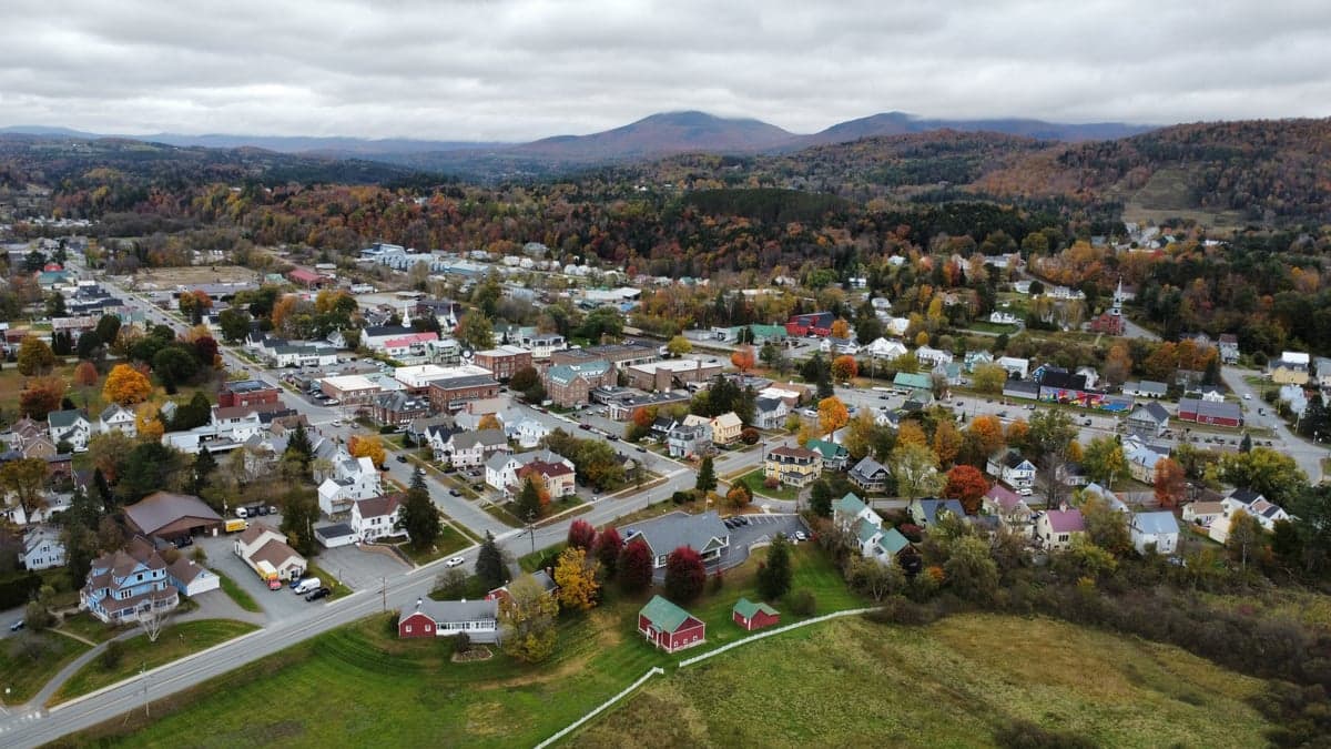
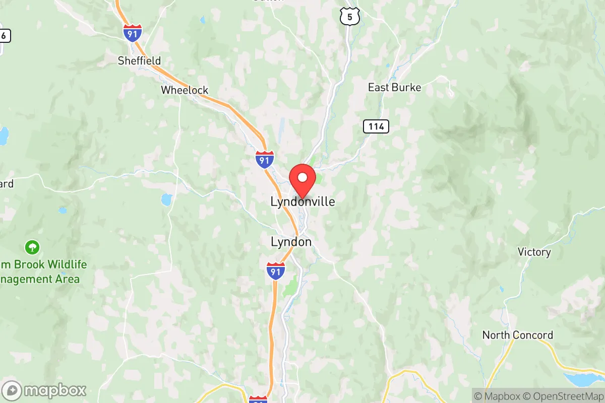
Lyndonville, Vermont, presents a compelling strategic option for those prioritizing resilience and self-sufficiency, largely due to its position in the Northeast Kingdom—a region defined by low population density, rugged terrain, and distance from major metropolitan centers. This small town of roughly 1,200 residents sits at the confluence of the Passumpsic River and the Moose River, offering a natural water supply and a defensible geography that is hard to replicate closer to the I-91 corridor. For a relocator concerned with civic unrest, mass casualty events, or systemic collapse, Lyndonville’s isolation is its primary asset: it’s roughly 90 miles from Burlington, 100 miles from Montreal, and over 150 miles from Boston, placing it well outside the immediate fallout zones and secondary chaos of larger cities.
Geographic position and natural advantages for long-term survival
Lyndonville’s location in Caledonia County is a strategic sweet spot for those seeking a balance between accessibility and remoteness. The town is nestled in a valley surrounded by the Green Mountains, with the nearby Burke Mountain providing both a natural barrier and a potential high-ground retreat. The area’s elevation—around 700 feet—offers a slight advantage in terms of cooler summers and a longer growing season than higher elevations, but the real draw is the abundance of surface water. The Passumpsic River runs through town, and the Moose River joins it just north, creating a reliable year-round water source that can be tapped for drinking, irrigation, and hydro power. The surrounding forests are dense with hardwoods and softwoods, providing timber for construction, fuel, and foraging. For a prepper, this means you’re not dependent on municipal infrastructure for basic survival—you can draw water, harvest wood, and hunt game (deer, turkey, small game) within a short walk of your property. The region’s low population density—about 40 people per square mile in Caledonia County—also means fewer competition for resources in a crisis, and the local culture of self-reliance and neighborly mutual aid aligns well with a conservative, preparedness-minded ethos.
Risks, exposures, and proximity to fallout-relevant landmarks
No location is without risk, and Lyndonville has its share of strategic vulnerabilities. The most immediate concern is the proximity to the Vermont Yankee nuclear power plant, located about 70 miles south in Vernon, VT. While the plant ceased operations in 2014, the spent fuel rods remain on-site in dry cask storage, and a catastrophic event—whether natural or man-made—could release radioactive material. Prevailing winds in the region are from the west and southwest, meaning a plume from Vermont Yankee would likely track northeast, potentially passing over Lyndonville. That said, the distance and the mountainous terrain would dilute and scatter any fallout significantly, making it a lower-tier risk compared to living within 20 miles of an active plant. Another exposure is the I-91 corridor, which runs about 10 miles west of Lyndonville. In a mass evacuation scenario, this highway could become a chokepoint for refugees fleeing the Northeast, but the town’s position off the main artery—via VT-114 and VT-5—offers some buffer. The nearest major city, Burlington, is a 90-minute drive, but its population of 45,000 is small enough that a collapse there wouldn’t generate the same refugee wave as a Boston or New York. The real risk is winter: Lyndonville averages 90 inches of snow annually, and a prolonged power outage during a blizzard could be deadly if you’re not prepared with backup heat, food stores, and a reliable vehicle. The town’s infrastructure is aging, and the local hospital—Northeastern Vermont Regional Hospital in St. Johnsbury, 10 miles south—is a small critical-access facility with limited trauma capacity, so serious medical emergencies would require a medevac to Dartmouth-Hitchcock in Lebanon, NH, 70 miles away.
Practical resilience for a relocator: food, water, energy, and defensibility
For a relocator serious about self-sufficiency, Lyndonville offers a strong foundation but requires deliberate investment. The town’s water supply is excellent: the Passumpsic River is clean enough for filtration and boiling, and many properties have private wells with depths of 100-300 feet, providing a secure groundwater source even if municipal systems fail. The growing season is short—roughly 100-120 frost-free days—but the fertile river valley soil supports gardens of potatoes, beans, squash, and cold-hardy greens. Local farms, like the Lyndonville Farmers Market and nearby organic operations, offer a network for bartering and bulk food purchases, but you’ll want to stockpile at least a year’s worth of non-perishables given the risk of supply chain disruptions during winter. Energy resilience is a mixed bag: the region has good solar potential despite the cloudy winters, and micro-hydro systems on the rivers are viable for those with water rights. Wood heat is the standard here, and most homes have wood stoves or boilers—a critical advantage if the grid goes down. Defensibility is decent but not fortress-level. Lyndonville’s layout is a classic New England village with a compact downtown and scattered rural homes, meaning you can secure a perimeter if you choose a property with natural barriers (hills, rivers, or dense forest). The local police force is small—about 6 officers—and the county sheriff’s office is in St. Johnsbury, so response times in a crisis could be hours. That makes a well-armed and trained household a practical necessity, not a paranoid fantasy. The town’s gun culture is strong, with local hunting and shooting sports common, so you won’t stand out for owning firearms. The biggest practical challenge is transportation: Lyndonville has no rail or major airport, and the roads can be impassable for days after a heavy snow, so a 4WD vehicle with snow tires and a backup ATV or snowmobile is essential.
The overall strategic picture for Lyndonville is one of calculated trade-offs. It’s not a bug-out bunker in the wilderness—it’s a small, functional community where you can integrate into a pre-existing network of self-reliant people while maintaining a low profile. The distance from major cities and nuclear targets is a genuine advantage, but the harsh winters and limited medical infrastructure demand a high level of personal preparedness. For a conservative relocator who values independence, community, and the ability to weather a long-term disruption, Lyndonville offers a realistic base of operations. It’s not for everyone—you’ll need to be comfortable with isolation, hard physical work, and the reality that help is far away. But if you’re looking for a place where you can build a resilient life without the constant hum of urban anxiety, this corner of Vermont deserves a serious look.
* Values derived from national, state, county, city and local statistics and may differ in a specific area. Last updated: 2026-05-04T02:45:10.000Z
Narrative content on this page is AI-generated and may contain mistakes. Verify any details that matter before acting on them.
ReloMaps may earn a commission from affiliate links at no extra cost to you.