Photo: Wikipedia
Strategic Assessment of Lewes, DE
Multiple tactical vulnerabilities. Population density, target proximity, or disaster risk are likely compounding. A retreat property and exit planning is required.
What does the Strategic Assessment tell us?
Our Strategic Assessment grades tactical survivability of an area. Major population centers, military targets, fallout zones, natural disasters, and border exposure all drive risk — lower exposure means a more defensible position in a crisis.
This is heavily inspired by Joel Skousen's Strategic Relocation book. Highly recommended you checkout the book ($)What does this tell us?
Our Strategic Assessment grades tactical survivability of an area. Major population centers, military targets, fallout zones, natural disasters, and border exposure all drive risk — lower exposure means a more defensible position in a crisis.
This is heavily inspired by Joel Skousen's Strategic Relocation book. Highly recommended you checkout the book ($)Strategic Pillars

Key Distances
Regional Safe Places
Below is our recommended "safe zones" in Delaware and the surrounding area based on our strategic heuristics. For most people, it's unrealistic to live in a “safe zone” full-time due to work, family or other personal reasons. They tend to be more rural. However, many of these areas are perfect for second homes and retreat properties that double as a vacation home or even a short-term rental.


Important Note: For informational purposes only. This does not mean nothing bad ever happens in the green zones. Please use common sense. This is based on public data and modeled with AI. We tried to take a conservative approach but mistakes happen. We update this regularly as new information becomes available.
Solar Generator Recommendations
Backup power matters more here than in safer locations. We've picked three solar generators across budgets and capacity tiers — start with the budget unit if you only need a few essentials, or step up if you want to run a fridge and HVAC for days at a time.

Jackery Portable Power Station Explorer 300
Budget OptionPower on the Go: Weighing only 11 lbs, it's convenient to set up and store with book-sized foldable solar panels

BLUETTI Portable Power Station AC180
Designed for both indoor and outdoor scenarios, AC180 is highly capable as it has a robost capacity and continuous output power.

EF ECOFLOW DELTA Pro Ultra Power Station
Upgraded PickEcoFlow DELTA Pro Ultra is a whole-home energy system designed to grow with your family. Integrated with the Smart Home Panel 2, it scales to meet your evolving energy needs — keeping your home powered, intelligent, and secure through every stage of life.
We earn a commission, at no additional cost to you.
Strategic Assessment Analysis
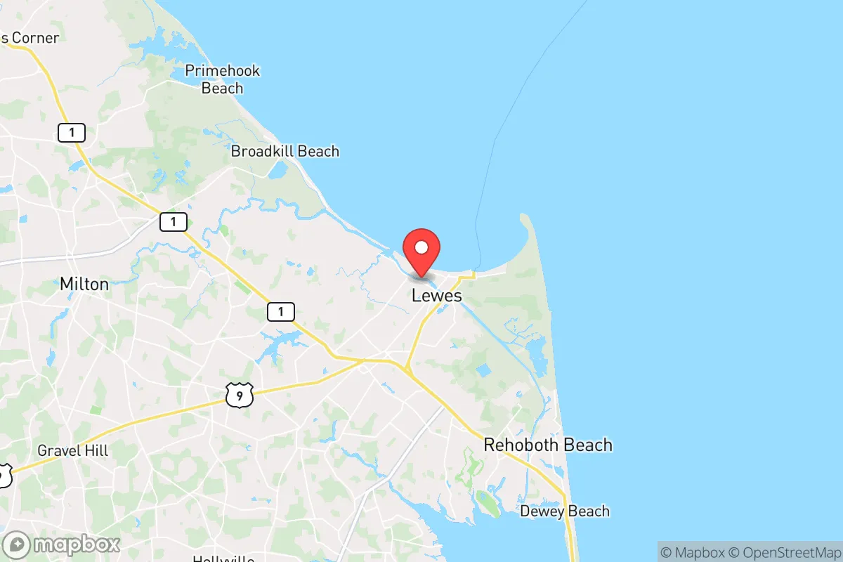
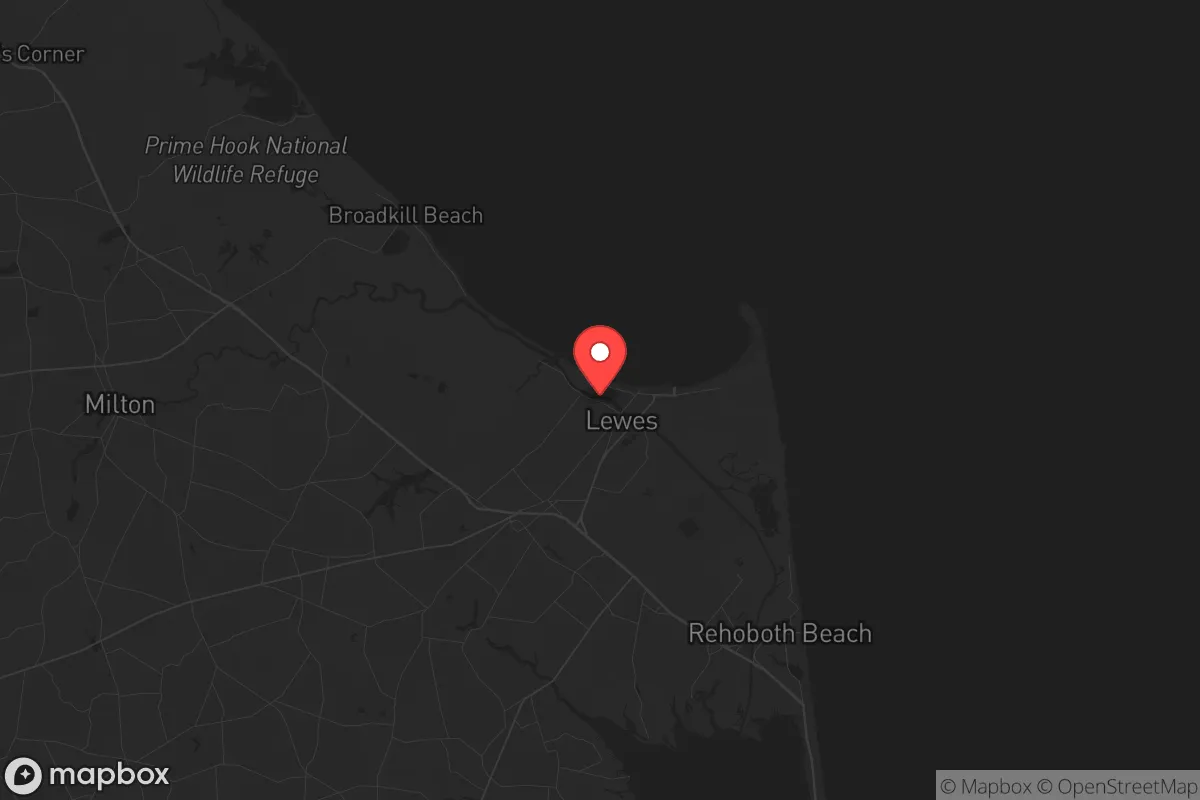
Lewes, Delaware, offers a surprisingly resilient strategic position for those prioritizing long-term preparedness, combining a historic coastal town’s isolation with proximity to critical infrastructure. Its location on the Delmarva Peninsula, roughly 80 miles from Philadelphia and 100 miles from Baltimore, provides a buffer from the immediate fallout of major metropolitan unrest while still allowing access to supply chains and medical resources. The town’s low population density—around 3,200 year-round residents—and its status as a regional hub for agriculture and maritime commerce make it a defensible base for a conservative-leaning relocator focused on self-reliance and community stability.
Geographic position and natural advantages for long-term security
Lewes sits at the mouth of the Delaware Bay, a natural choke point that historically has shielded the area from large-scale incursions. The surrounding Sussex County is characterized by flat, fertile farmland, extensive wetlands, and a temperate climate that supports year-round food production. This geography offers several strategic benefits: the land is easily defensible with limited entry points via Route 1 and Route 9, and the proximity to the Atlantic Ocean provides a potential escape route by water if overland corridors become compromised. The area’s low elevation—averaging just 10 feet above sea level—is a minor vulnerability, but the extensive network of canals and drainage ditches actually enhances water management and could be leveraged for irrigation or defensive barriers. The Cape May–Lewes Ferry, a 17-mile crossing, offers a secondary logistical link to New Jersey, but it’s a single point of failure that could be severed in a crisis, reinforcing the need for self-sufficiency on the peninsula.
Risks, exposures, and proximity to fallout-relevant landmarks
The primary risk for Lewes is its coastal exposure to hurricanes and nor’easters, which can disrupt power, communications, and transportation for days or weeks. The town sits within the FEMA-designated Zone A for storm surge, meaning a Category 2 or higher hurricane could inundate low-lying areas, though the historic district sits on slightly higher ground. More critically for a prepper mindset, Lewes is roughly 60 miles from the Salem Nuclear Generating Station in New Jersey, a boiling water reactor that has experienced multiple emergency shutdowns since 2010. A major incident there could contaminate the Delaware Bay and force an evacuation of the entire coastal zone. Additionally, the nearby Dover Air Force Base (30 miles north) is a strategic military hub that could become a target during large-scale conflict, drawing secondary threats to the region. The area’s reliance on the Chesapeake Bay Bridge and the Delaware Memorial Bridge for overland access to the rest of the East Coast creates a single-point vulnerability—if those bridges are compromised, the peninsula becomes an isolated island, which is both a defensive advantage and a logistical nightmare.
Practical resilience for a relocator: food, water, energy, and defensibility
For a relocator focused on practical resilience, Lewes offers strong fundamentals. The surrounding Sussex County is one of Delaware’s top agricultural producers, with over 100,000 acres of cropland growing corn, soybeans, and poultry. This means local food sources are abundant, and the area has a robust network of farmers’ markets, CSAs, and small-scale producers that can be tapped for barter or direct purchase. Water is less of a concern here than in arid regions—the water table is high, and private wells are common, though they require electricity to pump. A solar-powered well pump and a backup generator are essential investments. The local power grid is vulnerable to coastal storms, but the town has a municipal electric utility (Lewes Board of Public Works) that is more responsive than investor-owned utilities, with a history of restoring power within 24-48 hours after moderate events. Defensibility is aided by the town’s compact layout—most residential areas are within a 1-mile radius of the historic center, making it feasible to establish neighborhood watch or mutual-aid networks. The Lewes Volunteer Fire Department and the Sussex County Emergency Operations Center provide a baseline of organized response, but a relocator should plan to be self-sufficient for at least two weeks, given the potential for supply chain disruptions during a major event.
Overall strategic picture for a conservative relocator
Lewes presents a balanced strategic picture for someone seeking a prepared, low-profile base of operations. Its isolation from major urban centers reduces the risk of being caught in civil unrest or mass casualty events tied to metropolitan collapse, while its agricultural base and coastal access provide a foundation for long-term self-reliance. The trade-offs are real: the hurricane and nuclear risks require serious mitigation planning, and the reliance on a few key bridges means a relocator must have a secondary plan for evacuation or resupply by water. For a conservative-leaning individual or family who values community cohesion, limited government interference, and the ability to live quietly without drawing attention, Lewes offers a defensible niche. The key is to treat it as a base, not a fortress—invest in solar, water storage, and food production, build relationships with local farmers and tradespeople, and maintain a low profile. In a world where the state of the country and the world feels increasingly fragile, Lewes provides a realistic, grounded option for those who want to be prepared without living in a bunker.
* Values derived from national, state, county, city and local statistics and may differ in a specific area. Last updated: 2026-04-30T06:38:45.000Z
Narrative content on this page is AI-generated and may contain mistakes. Verify any details that matter before acting on them.
ReloMaps may earn a commission from affiliate links at no extra cost to you.