Photo: Wikipedia
Strategic Assessment of Lead, SD
Workable tactical position. Some exposure to population density or targets, but generally defensible in a crisis.
What does the Strategic Assessment tell us?
Our Strategic Assessment grades tactical survivability of an area. Major population centers, military targets, fallout zones, natural disasters, and border exposure all drive risk — lower exposure means a more defensible position in a crisis.
This is heavily inspired by Joel Skousen's Strategic Relocation book. Highly recommended you checkout the book ($)What does this tell us?
Our Strategic Assessment grades tactical survivability of an area. Major population centers, military targets, fallout zones, natural disasters, and border exposure all drive risk — lower exposure means a more defensible position in a crisis.
This is heavily inspired by Joel Skousen's Strategic Relocation book. Highly recommended you checkout the book ($)Strategic Pillars

Key Distances
Regional Safe Places
Below is our recommended "safe zones" in South Dakota and the surrounding area based on our strategic heuristics. For most people, it's unrealistic to live in a “safe zone” full-time due to work, family or other personal reasons. They tend to be more rural. However, many of these areas are perfect for second homes and retreat properties that double as a vacation home or even a short-term rental.


Important Note: For informational purposes only. This does not mean nothing bad ever happens in the green zones. Please use common sense. This is based on public data and modeled with AI. We tried to take a conservative approach but mistakes happen. We update this regularly as new information becomes available.
Solar Generator Recommendations
Backup power matters more here than in safer locations. We've picked three solar generators across budgets and capacity tiers — start with the budget unit if you only need a few essentials, or step up if you want to run a fridge and HVAC for days at a time.

Jackery Portable Power Station Explorer 300
Budget OptionPower on the Go: Weighing only 11 lbs, it's convenient to set up and store with book-sized foldable solar panels

BLUETTI Portable Power Station AC180
Designed for both indoor and outdoor scenarios, AC180 is highly capable as it has a robost capacity and continuous output power.

EF ECOFLOW DELTA Pro Ultra Power Station
Upgraded PickEcoFlow DELTA Pro Ultra is a whole-home energy system designed to grow with your family. Integrated with the Smart Home Panel 2, it scales to meet your evolving energy needs — keeping your home powered, intelligent, and secure through every stage of life.
We earn a commission, at no additional cost to you.
Strategic Assessment Analysis
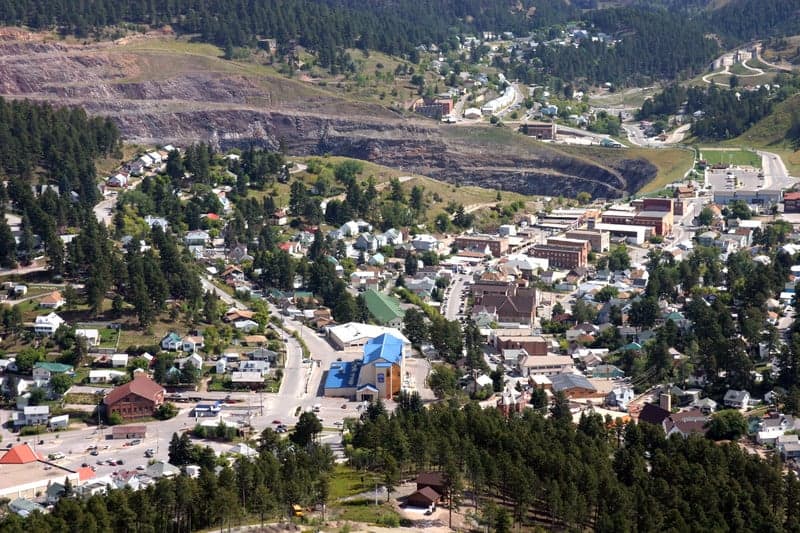
Lead, South Dakota, sits in a sweet spot for anyone thinking seriously about long-term resilience and strategic relocation. Tucked into the northern Black Hills, this former gold mining town offers a combination of geographic isolation, natural resources, and low population density that’s hard to beat in the lower 48. It’s far enough from major metro areas to avoid the worst of urban collapse scenarios, yet close enough to essential services and supply routes to avoid being truly cut off. For a conservative-leaning individual or family looking to weather civic unrest, economic instability, or even larger-scale disasters, Lead presents a compelling case—but it’s not without its own set of trade-offs that demand a clear-eyed assessment.
Geographic position and natural advantages for long-term survival
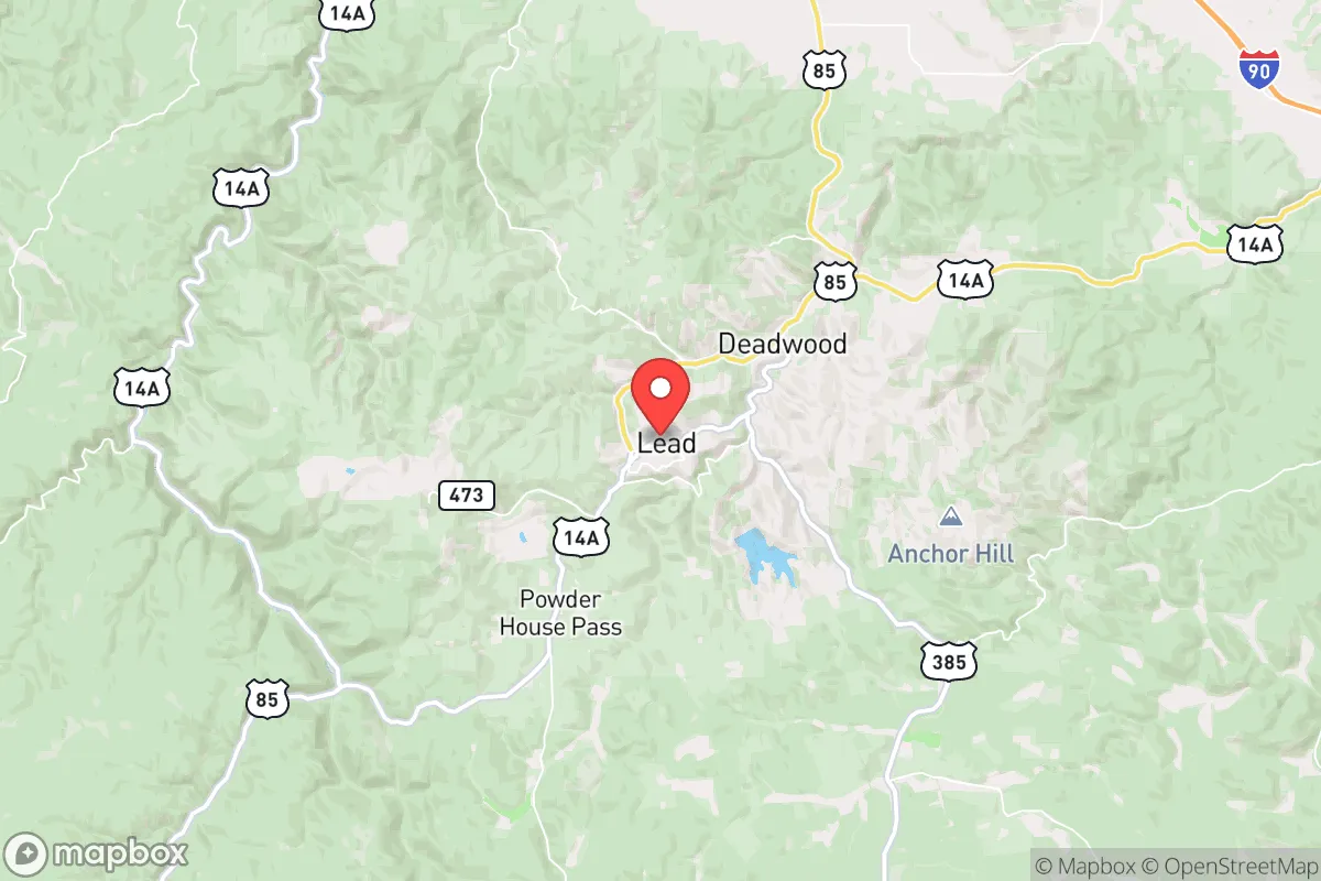
Lead’s location is its strongest card. Sitting at roughly 5,300 feet elevation in the northern Black Hills, the town is surrounded by the Black Hills National Forest, which provides a natural buffer against encroachment and development. The nearest city of any real size is Rapid City, about 45 miles east—close enough for supply runs or medical care, but far enough that you won’t be caught in the immediate fallout of a major urban disruption. Denver is over 400 miles away, and Minneapolis is nearly 600. That kind of distance from major population centers is a massive advantage in a grid-down or civil unrest scenario, where highways become chokepoints and cities become danger zones.
The terrain itself is defensible. Steep hills, narrow valleys, and dense forest make the area hard to navigate for anyone unfamiliar with it. Multiple dead-end roads and limited access points mean a small, prepared group could effectively control movement into the area. The Homestake Mine, which operated for over a century, left behind a network of underground tunnels and infrastructure that could theoretically be repurposed for storage, shelter, or even emergency water collection. While the mine is now a research facility, the local knowledge of underground systems is still present among longtime residents. The climate is a double-edged sword—cold winters with heavy snow can be a hardship, but they also discourage casual visitors and provide natural water storage in the form of snowpack.
Risks, exposures, and proximity to fallout-relevant landmarks
No location is perfect, and Lead has some real vulnerabilities that a prepper needs to account for. The most obvious is its proximity to Ellsworth Air Force Base, located about 50 miles east near Rapid City. Ellsworth is home to the 28th Bomb Wing, operating B-1B Lancers and, increasingly, B-21 Raiders. In a major conflict scenario, that base is a high-value target. A ground burst or airburst nuclear weapon on Ellsworth would produce significant fallout, and prevailing winds in the region generally blow from west to east, meaning Lead is upwind of the base—a small mercy. But a large enough detonation could still send fallout into the Black Hills depending on weather patterns. You’re not in the immediate blast zone, but you’re in the risk radius.
Another concern is the proximity to the Pine Ridge Indian Reservation, about 80 miles south. The reservation has some of the highest poverty and crime rates in the country, and in a collapse scenario, mass migration from that area toward the Black Hills is a real possibility. The same goes for Rapid City itself, which has a population of about 75,000 and its own share of social tensions. If things go sideways, Lead could see a wave of refugees moving west into the hills. The town’s small population—roughly 3,000—means there’s limited capacity to absorb newcomers without straining local resources. The single main road in and out, US-14A, is a winding two-lane highway that can be easily blocked, but that also means your own supply lines are fragile.
Wildfire is a recurring natural risk. The Black Hills are a fire-prone ecosystem, and the 2021 Legion Lake Fire and the 2000 Jasper Fire are reminders that a dry summer can turn the forest into a tinderbox. Lead’s location in a valley can trap smoke and make evacuation difficult. Earthquake risk is low, but the area does experience minor seismic activity related to old mining operations. Tornadoes are rare in the hills, though not impossible. Overall, the man-made risks—military target proximity and potential refugee flow—are more concerning than natural disasters.
Practical resilience for a relocator: food, water, energy, and defensibility
Water is where Lead shines. The area gets about 25 inches of precipitation annually, with significant snowmelt in spring. Numerous small creeks and streams run through the hills, and the groundwater table is generally accessible via wells. The old mine shafts also collect water, though you’d want to test it for heavy metals before relying on it. For a family, drilling a well or setting up rainwater catchment from a metal roof is straightforward here. The city’s municipal water comes from a combination of surface and groundwater sources, but in a grid-down scenario, having your own supply is non-negotiable.
Food is more of a challenge. The growing season is short—typically mid-May to late September—and the soil is rocky and thin. You can grow cold-hardy crops like potatoes, carrots, kale, and some grains, but you won’t be feeding a family on a quarter-acre garden alone. Hunting and fishing are viable options: deer, elk, and turkey are abundant in the national forest, and trout streams are plentiful. But you’ll need to be proficient with a rifle and know the regulations, which could change in a crisis. For long-term food security, you’d want to establish relationships with local ranchers and farmers in the surrounding area, many of whom are conservative and self-reliant themselves. The Lead-Deadwood area has a strong ranching tradition, and that community network is a resilience asset that can’t be overstated.
Energy is manageable. The Black Hills get plenty of sun for solar panels, though winter days are short and snow cover can reduce output. Wind is consistent on the ridgelines, and small-scale hydro from a creek is possible if you have the right topography. Wood heat is the default backup—the national forest offers firewood permits, and a good wood stove is standard in most homes here. Propane is widely available for cooking and backup heating. The local power grid is served by Black Hills Energy, which is reasonably reliable, but in a prolonged outage, you’ll want to be off-grid capable. Defensibility is excellent for a small group. The town’s layout, with its steep streets and limited entry points, makes it easy to monitor approaches. Neighbors tend to know each other, and the local culture is heavily armed and self-sufficient. The Lead-Deadwood area has a strong gun culture, and concealed carry is common. That’s a double-edged sword—it means you’re surrounded by people who can defend themselves, but it also means any conflict could escalate quickly.
The overall strategic picture for Lead is one of high potential paired with real, manageable risks. It’s not a bug-out location for the unprepared—the winters are harsh, the growing season is short, and the remoteness can be isolating. But for someone who’s willing to put in the work, stockpile supplies, and integrate into the local community, it offers one of the best combinations of natural defense, resource availability, and distance from major threats in the continental United States. The proximity to Ellsworth is the single biggest wildcard, but it’s a risk you can mitigate with a good fallout shelter and a plan for the first 72 hours. If you’re looking for a place to ride out the storm—whatever that storm ends up being—Lead deserves a serious look. Just don’t expect it to be easy. That’s the point.
* Values derived from national, state, county, city and local statistics and may differ in a specific area. Last updated: 2026-04-30T12:57:47.000Z
Narrative content on this page is AI-generated and may contain mistakes. Verify any details that matter before acting on them.
ReloMaps may earn a commission from affiliate links at no extra cost to you.