
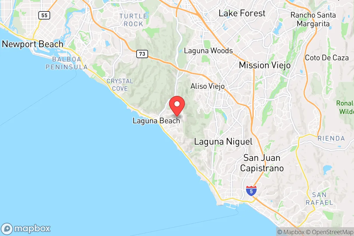
Strategic Assessment of Laguna Beach, CA
Multiple tactical vulnerabilities. Population density, target proximity, or disaster risk are likely compounding. A retreat property and exit planning is required.
What does the Strategic Assessment tell us?
Our Strategic Assessment grades tactical survivability of an area. Major population centers, military targets, fallout zones, natural disasters, and border exposure all drive risk — lower exposure means a more defensible position in a crisis.
This is heavily inspired by Joel Skousen's Strategic Relocation book. Highly recommended you checkout the book ($)What does this tell us?
Our Strategic Assessment grades tactical survivability of an area. Major population centers, military targets, fallout zones, natural disasters, and border exposure all drive risk — lower exposure means a more defensible position in a crisis.
This is heavily inspired by Joel Skousen's Strategic Relocation book. Highly recommended you checkout the book ($)Strategic Pillars

Key Distances
Regional Safe Places
Below is our recommended "safe zones" in California and the surrounding area based on our strategic heuristics. For most people, it's unrealistic to live in a “safe zone” full-time due to work, family or other personal reasons. They tend to be more rural. However, many of these areas are perfect for second homes and retreat properties that double as a vacation home or even a short-term rental.


Important Note: For informational purposes only. This does not mean nothing bad ever happens in the green zones. Please use common sense. This is based on public data and modeled with AI. We tried to take a conservative approach but mistakes happen. We update this regularly as new information becomes available.
Solar Generator Recommendations
Backup power matters more here than in safer locations. We've picked three solar generators across budgets and capacity tiers — start with the budget unit if you only need a few essentials, or step up if you want to run a fridge and HVAC for days at a time.

Jackery Portable Power Station Explorer 300
Budget OptionPower on the Go: Weighing only 11 lbs, it's convenient to set up and store with book-sized foldable solar panels

BLUETTI Portable Power Station AC180
Designed for both indoor and outdoor scenarios, AC180 is highly capable as it has a robost capacity and continuous output power.

EF ECOFLOW DELTA Pro Ultra Power Station
Upgraded PickEcoFlow DELTA Pro Ultra is a whole-home energy system designed to grow with your family. Integrated with the Smart Home Panel 2, it scales to meet your evolving energy needs — keeping your home powered, intelligent, and secure through every stage of life.
We earn a commission, at no additional cost to you.
Strategic Assessment Analysis
Laguna Beach, California, presents a paradox for the relocation-minded conservative seeking strategic resilience: it offers exceptional natural defensibility and a buffer from the immediate blast zones of major metropolitan targets, yet its dependence on fragile coastal infrastructure and proximity to high-value military and economic assets in Southern California creates significant long-term vulnerabilities. For a single individual or family prioritizing disaster readiness and self-sufficiency, this Orange County enclave provides a strong geographic redoubt but demands a clear-eyed assessment of its exposure to cascading failures from nearby population centers and critical infrastructure. The area’s narrow coastal shelf, limited egress routes, and reliance on imported water and energy make it a location that rewards preparation but punishes complacency.
Geographic position and natural advantages for disaster readiness
Laguna Beach’s primary strategic strength is its physical geography. Nestled between the Pacific Ocean and the steep, undeveloped ridgelines of the San Joaquin Hills, the city occupies a natural amphitheater that is difficult to approach from the interior. The only major road access is via Pacific Coast Highway (State Route 1) and a few winding canyon roads—Laguna Canyon Road (SR-133) and Crown Valley Parkway—which can be easily monitored and, if necessary, controlled. This chokepoint geography is a double-edged sword: it makes the area inherently defensible against ground-based threats, but it also means that evacuation during a wildfire or tsunami warning can become a gridlocked nightmare. The San Joaquin Hills provide a natural barrier against blast overpressure and fallout from a nuclear detonation in the Los Angeles Basin or the Port of Long Beach, as the hills would absorb much of the initial shockwave and block line-of-sight radiation. The marine layer and prevailing onshore winds also help disperse airborne contaminants, though this is not a reliable defense. For a relocator, the key advantage is that Laguna Beach sits outside the immediate blast radius of any likely high-value target—such as the Port of Los Angeles, San Pedro, or Camp Pendleton—while still being close enough to benefit from the economic and medical resources of Orange County in non-crisis times.
Risks, exposures, and proximity to fallout-relevant landmarks
The area’s proximity to high-consequence targets is the most significant strategic liability. Laguna Beach lies roughly 40 miles southeast of the Port of Los Angeles and the Port of Long Beach, the busiest container ports in the Western Hemisphere and primary targets for a strategic strike. It is also about 20 miles northwest of Camp Pendleton, a major Marine Corps base that would be a high-priority military target. In a conflict scenario, fallout patterns from a strike on either location could drift over Laguna Beach depending on wind direction, though the prevailing westerlies typically push contamination out to sea. The city is also within 50 miles of the San Onofre Nuclear Generating Station (now decommissioned but still storing spent fuel), which presents a radiological risk from accident or sabotage. Beyond man-made threats, the area faces natural hazards: wildfire risk is extreme, as the coastal sage scrub and chaparral in the surrounding canyons are highly flammable, and the 1993 Laguna Beach fire (which destroyed over 400 homes) is a stark reminder. Earthquake risk is moderate to high, with the nearby San Joaquin Hills blind thrust fault capable of producing a 6.5–7.0 magnitude event. A major quake would likely sever the single water pipeline from the Metropolitan Water District and damage the San Joaquin Hills Transportation Corridor, isolating the city for days. For a conservative relocator, the calculus is clear: the area is not a primary target, but it is in the shadow of several, and its infrastructure is brittle.
Practical resilience for a relocator: food, water, energy, and defensibility
For a family or individual serious about self-sufficiency, Laguna Beach presents a mixed picture. Water is the single greatest vulnerability. The city relies almost entirely on imported water from the Colorado River and the State Water Project, delivered via the Diemer Filtration Plant in Yorba Linda. Local groundwater is minimal, and desalination is not a municipal option. A prolonged disruption to the aqueducts—whether from earthquake, cyberattack, or sabotage—would leave residents dependent on stored water within 72 hours. Rainwater catchment is possible but limited by the region’s semi-arid climate (average 13 inches per year). Food resilience is similarly constrained: the city has no significant agricultural land, and the nearest major food distribution centers are in Anaheim and Irvine, both of which could be disrupted. However, the Pacific Ocean provides a reliable protein source for those with fishing skills, and the mild climate allows for year-round vegetable gardening on small lots. Energy resilience is better than most of coastal California. The area has high solar insolation, and many homes already have rooftop solar, though battery storage is essential for grid independence. Natural gas is the primary heating fuel, but the pipeline network is vulnerable to earthquake damage. Defensibility is the area’s strongest suit: the limited road access and rugged terrain make it easy to establish checkpoints and patrol perimeters. The community is relatively affluent and politically engaged, which can translate into organized neighborhood watch and mutual-aid networks—but it also means that many residents are unprepared for a long-term grid-down scenario. A relocator should plan to store at least 90 days of food and water, invest in a solar-plus-battery system, and develop relationships with neighbors who have complementary skills (medical, mechanical, security).
Overall, Laguna Beach offers a strategic position for those who value natural beauty and a buffer from urban chaos, but it is not a standalone survival location. Its dependence on fragile lifelines—imported water, a single highway, and the broader Southern California economy—means that true resilience requires significant personal investment in off-grid infrastructure and a willingness to adapt to the area’s inherent constraints. For a conservative relocator who can afford the premium, it is a defensible coastal redoubt with excellent community resources, but it should be viewed as a base camp for a broader regional strategy rather than a final bug-out location. The key is to treat Laguna Beach as a high-value asset that requires active management, not a passive haven. If you can secure your own water, power, and food supply, and if you are comfortable with the trade-offs of living in a high-cost, high-risk environment, this area can work. If not, the vulnerabilities will outweigh the advantages.
* Values derived from national, state, county, city and local statistics and may differ in a specific area. Last updated: 2026-06-08T04:41:54.000Z
Narrative content on this page is AI-generated and may contain mistakes. Verify any details that matter before acting on them.
ReloMaps may earn a commission from affiliate links at no extra cost to you.