Photo: Wikipedia
Strategic Assessment of Bremer County
Workable tactical position. Some exposure to population density or targets, but generally defensible in a crisis.
What does the Strategic Assessment tell us?
Our Strategic Assessment grades tactical survivability of an area. Major population centers, military targets, fallout zones, natural disasters, and border exposure all drive risk — lower exposure means a more defensible position in a crisis.
This is heavily inspired by Joel Skousen's Strategic Relocation book. Highly recommended you checkout the book ($)What does this tell us?
Our Strategic Assessment grades tactical survivability of an area. Major population centers, military targets, fallout zones, natural disasters, and border exposure all drive risk — lower exposure means a more defensible position in a crisis.
This is heavily inspired by Joel Skousen's Strategic Relocation book. Highly recommended you checkout the book ($)Strategic Pillars

Key Distances
Strategic Assessment Analysis
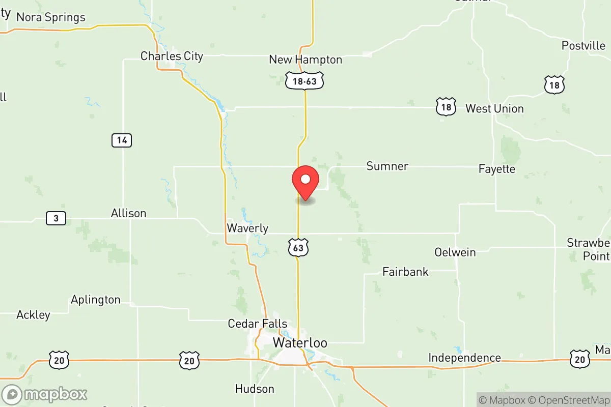
Bremer County, Iowa, offers a compelling mix of Midwestern stability and strategic depth for those prioritizing resilience and self-sufficiency. Its location in the northeastern part of the state, roughly 100 miles from the Minneapolis-St. Paul metro area and 150 miles from Des Moines, places it far enough from major population centers to avoid the worst of urban collapse scenarios, yet close enough to access critical supply chains when they function. The county’s economic backbone is agriculture and light manufacturing, anchored by the city of Waverly (population ~10,400) and the smaller towns of Sumner, Tripoli, and Readlyn. This is not a boom-or-bust region; it’s a place where steady, local economies and strong community ties have historically weathered downturns. For a relocator thinking about long-term stability, Bremer County’s low population density (roughly 50 people per square mile) and its position outside the direct shadow of any single major city make it a defensible, low-profile choice.
Geographic position and natural advantages for long-term stability
Bremer County sits squarely in the Cedar River Valley, a landscape of rolling hills, wooded bluffs, and fertile bottomlands that provide both natural beauty and practical advantages. The Cedar River itself runs through the county, passing through Waverly and providing a reliable surface water source—a critical asset in any extended disruption scenario. The county’s topography is not mountainous, but its gentle hills and river valleys offer natural drainage and some defensible high ground, particularly around the unincorporated areas near the Cedar River Wildlife Area. The soil is among the richest in the state, part of the Iowan Surface, meaning that even a modest homestead can produce substantial food. The county’s position in the Upper Midwest also means a temperate climate with four distinct seasons, reducing the risk of extreme heat events that plague the southern plains, while still allowing for a full growing season (roughly 150 frost-free days). For a relocator, this means you can grow a significant portion of your own food, store it through cold winters, and rely on a deep aquifer that supplies most of the county’s municipal water. The nearest major military installation is the Iowa Army Ammunition Plant in Middletown (about 90 miles south), which is a potential target but far enough away to avoid direct fallout concerns for Bremer County.
Risks, exposures, and proximity to fallout-relevant landmarks
No location is risk-free, and Bremer County has its own set of exposures that a serious relocator must weigh. The most significant man-made risk comes from the Duane Arnold Energy Center, a decommissioned nuclear power plant located just 20 miles southeast in Palo, Iowa. While the plant is permanently shut down (since 2020), spent fuel remains on site in dry cask storage. A catastrophic event at this facility—though unlikely—could theoretically affect the southern part of Bremer County, particularly the town of Readlyn, which lies about 15 miles from the site. The county is also within 150 miles of the Minneapolis-St. Paul metro area (population 3.7 million), which in a major national crisis could become a source of refugee flow or supply chain disruption. On the natural disaster front, the Cedar River is prone to flooding; Waverly experienced significant floods in 2008 and 2016, with water reaching downtown areas. Tornado risk is moderate but real—Iowa averages 50 tornadoes per year, and Bremer County sits in the traditional “Tornado Alley” zone. The county has no major refineries, ports, or military bases within its borders, which is a double-edged sword: it reduces direct target risk but also means no local fuel production or heavy industrial capacity. The nearest major fuel pipeline is the Explorer Pipeline, which runs about 60 miles east near Dubuque. For a relocator, the key takeaway is that Bremer County is not a high-value target, but it is not isolated from regional risks—especially flooding and the decommissioned nuclear site.
Practical resilience for a relocator: food, water, energy, and defensibility
Bremer County scores well on the fundamentals of self-sufficiency. Food production is the county’s strongest asset: it is part of Iowa’s agricultural heartland, with corn, soybeans, and livestock operations dominating the landscape. Local farmers’ markets operate in Waverly and Sumner from May through October, and the county has several U-pick orchards and vegetable farms. For a relocator looking to grow their own food, the soil is excellent, and water is accessible via wells (average depth 100-200 feet). Water security is robust: the Cedar River provides a surface source, and the Jordan Aquifer underlies the region, supplying clean groundwater. Most rural properties have private wells, and municipal systems in Waverly and Tripoli are well-maintained. Energy resilience is moderate: the county is served by Alliant Energy, which relies on a mix of coal, natural gas, and renewables. There is growing solar adoption, but no large-scale battery storage or community microgrids yet. For off-grid capability, the rolling hills offer decent wind potential for small turbines, and the wooded areas provide biomass for heating. Defensibility is a mixed picture: the county’s rural nature means low population density and few choke points, but the open agricultural terrain offers little natural cover. The best defensible positions are along the wooded bluffs of the Cedar River, particularly near the unincorporated areas of Bremer and the Waverly-Shell Rock Wildlife Area. The county has a strong local law enforcement presence (Bremer County Sheriff’s Office) and a well-regarded emergency management agency, but no formal militia or organized preparedness groups. For a relocator, the practical takeaway is that Bremer County offers excellent food and water security, moderate energy options, and a defensible but not fortress-like landscape—ideal for a family or small group willing to invest in their own infrastructure.
The overall strategic picture for Bremer County is one of quiet, understated resilience. It is not a prepper’s paradise with mountains and isolation, nor is it a vulnerable urban fringe. Instead, it offers a balanced profile: strong agricultural self-sufficiency, reliable water from the Cedar River and deep aquifers, low target risk, and a community that values neighborly cooperation. The main drawbacks are the proximity to the Duane Arnold spent fuel site, the flood risk along the Cedar River, and the lack of heavy industrial resources for long-term rebuilding. For a relocator with a slightly conservative leaning—someone who values local control, self-reliance, and community stability—Bremer County represents a solid, defensible choice in the Upper Midwest. It is the kind of place where you can raise a family, grow your own food, and ride out most disruptions without being on anyone’s radar. The key is to choose your specific location carefully: avoid the floodplain near Waverly, stay at least 20 miles from the nuclear site, and invest in your own well and solar array. Done right, Bremer County can be a quiet anchor in an uncertain future.
* Values derived from national, state, county, city and local statistics and may differ in a specific area. Last updated: 2026-06-12T20:43:15.000Z
Narrative content on this page is AI-generated and may contain mistakes. Verify any details that matter before acting on them.
ReloMaps may earn a commission from affiliate links at no extra cost to you.