Photo: Wikipedia
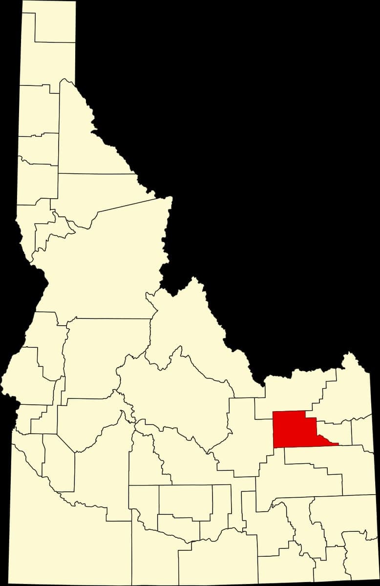
Strategic Assessment of Jefferson County
Strong survivability profile. Good buffer from population centers, with manageable environmental and tactical risks.
What does the Strategic Assessment tell us?
Our Strategic Assessment grades tactical survivability of an area. Major population centers, military targets, fallout zones, natural disasters, and border exposure all drive risk — lower exposure means a more defensible position in a crisis.
This is heavily inspired by Joel Skousen's Strategic Relocation book. Highly recommended you checkout the book ($)What does this tell us?
Our Strategic Assessment grades tactical survivability of an area. Major population centers, military targets, fallout zones, natural disasters, and border exposure all drive risk — lower exposure means a more defensible position in a crisis.
This is heavily inspired by Joel Skousen's Strategic Relocation book. Highly recommended you checkout the book ($)Strategic Pillars

Key Distances
Strategic Assessment Analysis
Jefferson County, Idaho, offers a compelling strategic position for those prioritizing resilience and distance from major population centers, sitting squarely in the agricultural heart of the Snake River Plain. Its location, roughly 20 miles from Idaho Falls and over 200 miles from Boise, provides a buffer from the cascading effects of urban unrest or infrastructure collapse, while still offering access to essential services. The county’s economic and social fabric is woven around small towns like Rigby, the county seat, and Roberts, where community ties remain strong and self-reliance is a lived tradition rather than a theoretical concept. For a relocator assessing long-term stability, Jefferson County presents a low-profile, high-utility option in a state that consistently ranks among the most prepared for disruptions.
Geographic position and natural advantages for long-term stability
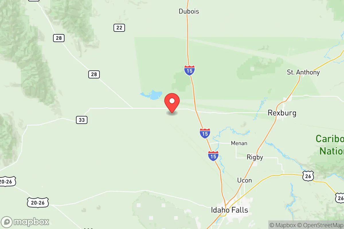
Jefferson County’s geography is defined by the broad, fertile Snake River Plain, which provides a reliable agricultural base and a relatively temperate climate compared to higher-elevation Idaho regions. The county is bisected by the Snake River itself, a major water artery that supports irrigation for crops like potatoes, wheat, and alfalfa, and offers a consistent freshwater source for both household use and small-scale farming. The terrain is mostly flat to gently rolling, which simplifies construction, road maintenance, and defensive positioning—no steep canyons to trap you or narrow valleys to get funneled into. The area sits at roughly 4,800 feet elevation, which means cold winters but manageable snowfall, and summers that are dry and hot enough for extended growing seasons. Critically, the county is far from the seismic risks of the Wasatch Front or the volcanic zones of eastern Idaho, and its position on the eastern edge of the Mountain Time Zone puts it hours away from any major coastal fallout zones. The nearby Caribou-Targhee National Forest, about 30 miles east, offers a remote retreat option if things go sideways, but the county itself is open enough to provide clear sightlines and early warning of any approaching threats.
Risks, exposures, and proximity to fallout-relevant landmarks
No location is without risk, and Jefferson County’s primary exposure comes from its proximity to the Idaho National Laboratory (INL), a sprawling nuclear research and testing facility that occupies much of the western part of the county. The INL, located about 20 miles west of Rigby, handles radioactive materials and operates several reactors, making it a potential target for both accidental release and deliberate attack. While the facility has a strong safety record, a major incident there could render large swaths of the county uninhabitable or require rapid evacuation. Additionally, the county lies within 50 miles of the Mountain Home Air Force Base (southwest), which, while not a primary nuclear strike target, could become a secondary target in a conflict scenario. The Port of Lewiston, about 200 miles north, is a major grain and fuel shipping hub on the Columbia-Snake river system, and while not a direct threat, its disruption could ripple through supply chains. On the positive side, Jefferson County is far from the Salt Lake City metropolitan area (about 200 miles south), which would be a high-value target in any major conflict, and it sits well outside the blast and fallout zones of any coastal or inland urban centers. The county’s low population density—roughly 30,000 people spread over 1,100 square miles—means that even a localized event would leave plenty of room to maneuver.
Practical resilience for a relocator: food, water, energy, and defensibility
For someone serious about self-sufficiency, Jefferson County checks most of the boxes. Water is the biggest win: the Snake River and its tributaries provide surface water that can be diverted for irrigation and, with proper treatment, for drinking. Groundwater is also accessible via wells, with the Eastern Snake River Plain Aquifer being one of the largest and most productive in the country. Food production is the county’s backbone—local farms produce potatoes, barley, wheat, and hay, and there are numerous small-scale livestock operations. The Jefferson County Farmers Market in Rigby and local co-ops make it easy to source directly from producers, and the growing season (roughly May to September) is long enough for a serious garden. Energy is a mixed bag: the county is served by Rocky Mountain Power, which relies on a mix of coal, natural gas, and hydro, but grid outages are rare compared to coastal areas. For off-grid setups, solar is viable given the 200+ sunny days per year, and wind is moderate but not a primary resource. Defensibility is where the county shines—the open terrain means no one can approach without being seen, and the small towns (Rigby, Roberts, Menan, Lewisville) are tight-knit enough that strangers are noticed quickly. The county has a strong sheriff’s department and a culture of gun ownership, which aligns with a prepper mindset. The main practical downside is distance from major medical facilities—the nearest Level 1 trauma center is in Idaho Falls (20-30 minutes from Rigby), which is fine for routine care but a concern for serious emergencies during a crisis.
The overall strategic picture for Jefferson County is one of balanced risk and high reward for a relocator with a conservative, self-reliant outlook. You get a solid agricultural base, abundant water, low population density, and a community that values independence—all within a state that has some of the most favorable gun laws, property rights, and minimal zoning in the nation. The INL is a real wildcard, but its presence also means the area has a skilled workforce and infrastructure that most rural counties lack. If you’re looking to put down roots in a place that can weather economic collapse, civil unrest, or even a limited conflict, Jefferson County offers a defensible, resource-rich position without the isolation that makes some rural areas impractical. Just keep a go-bag ready for the INL scenario, and you’ll be as prepared as anywhere in the lower 48.
* Values derived from national, state, county, city and local statistics and may differ in a specific area. Last updated: 2026-05-09T18:50:34.000Z
Narrative content on this page is AI-generated and may contain mistakes. Verify any details that matter before acting on them.
ReloMaps may earn a commission from affiliate links at no extra cost to you.