
Photo: Wikipedia
Strategic Assessment of Fremont County
Deep buffer from population centers and strategic targets. Low natural disaster risk and minimal exposure to border or coastal threats.
What does the Strategic Assessment tell us?
Our Strategic Assessment grades tactical survivability of an area. Major population centers, military targets, fallout zones, natural disasters, and border exposure all drive risk — lower exposure means a more defensible position in a crisis.
This is heavily inspired by Joel Skousen's Strategic Relocation book. Highly recommended you checkout the book ($)What does this tell us?
Our Strategic Assessment grades tactical survivability of an area. Major population centers, military targets, fallout zones, natural disasters, and border exposure all drive risk — lower exposure means a more defensible position in a crisis.
This is heavily inspired by Joel Skousen's Strategic Relocation book. Highly recommended you checkout the book ($)Strategic Pillars

Key Distances
Strategic Assessment Analysis
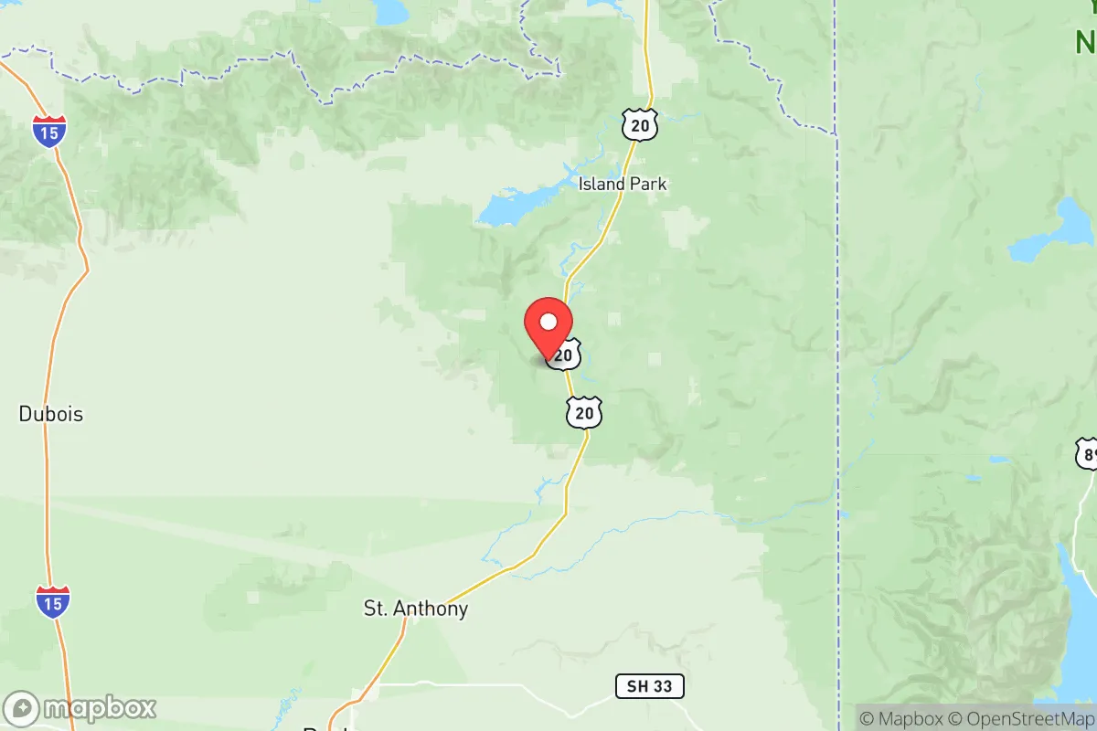
Fremont County, Idaho, sits in a sweet spot for those thinking long-term about resilience and security. Tucked against the Montana border and anchored by the small city of St. Anthony, this area offers a combination of geographic isolation, natural resources, and low population density that makes it a serious contender for relocation. The county’s position along the Henrys Fork of the Snake River and its proximity to the Teton Range provide both defensive depth and sustainable water access, while its distance from major urban centers like Boise (roughly 270 miles) and Salt Lake City (about 200 miles) reduces exposure to the chaos that often accompanies large-scale disruptions.
Geographic position and natural advantages for long-term security
Fremont County’s location is its primary strategic asset. The county is bordered by the Continental Divide to the east and the Centennial Mountains to the north, creating natural barriers that slow movement and provide early warning of any approach. The Henry's Fork of the Snake River runs through the county, offering a reliable water source that is less contested than in arid regions. The Island Park Reservoir and Mesa Falls further bolster water security, with the reservoir holding over 100,000 acre-feet of water. The county’s elevation—averaging around 5,000 feet—means cooler summers and heavy winter snowpack, which feeds the watershed and reduces wildfire risk compared to lower-elevation areas. The Targhee National Forest covers much of the eastern part of the county, providing timber, game, and forage. For a relocator, this means you’re not just buying land; you’re buying into a system of natural defenses and renewable resources that can sustain a household through extended disruptions.
Risks, exposures, and proximity to fallout-relevant landmarks
No area is without vulnerabilities, and Fremont County has a few that demand attention. The most significant risk is its proximity to Yellowstone National Park, whose caldera lies roughly 50 miles to the west. While a supervolcano eruption is a low-probability event, the ashfall and seismic activity could disrupt the region for years. More immediate concerns include the Idaho National Laboratory (INL), about 60 miles southwest near Idaho Falls. The INL handles nuclear research and waste storage; a major incident there could send fallout across the Snake River Plain, though prevailing winds typically blow eastward, away from Fremont County. The county also sits near the Wasatch Fault zone, which could produce a 7.0+ earthquake, though the risk is moderate compared to areas directly on the fault. On the human side, the county’s main highway—U.S. Route 20—runs from Idaho Falls to West Yellowstone, meaning any evacuation from the Yellowstone area could funnel thousands through St. Anthony and Ashton. This is a double-edged sword: it provides a route for resupply but also a vector for unwanted movement. The nearest major military installation is Mountain Home Air Force Base, about 200 miles southwest, which is far enough to avoid direct fallout but close enough that a base lockdown could ripple through supply chains.
Practical resilience for a relocator: food, water, energy, and defensibility
For someone serious about self-sufficiency, Fremont County delivers on the basics. Water is abundant: the Henrys Fork and its tributaries are fed by snowmelt, and groundwater is accessible via shallow wells in most areas. The county’s agricultural history means irrigated farmland is common, particularly around Parker and Teton, where you can grow potatoes, hay, and grains. The growing season is short—about 90 to 110 days—so cold-hardy crops and greenhouses are essential. Hunting and fishing are excellent: elk, deer, and moose are plentiful in the national forest, and the Henrys Fork is a world-class trout fishery. For energy, the county has hydroelectric potential from the river, and solar works well despite the latitude—summer days are long, and winter snow reflects light onto panels. Wood heating is the norm, with public lands offering firewood permits. Defensibility is strong: the county’s terrain—rolling hills, river valleys, and forested ridges—provides natural chokepoints. A small group can monitor the few paved roads (U.S. 20, State Highway 47, and State Highway 32) and the network of unpaved Forest Service roads. The population density is about 4.5 people per square mile, meaning you can have significant buffer from neighbors. The county seat, St. Anthony, has a population of around 3,500, with basic services like a hospital, grocery stores, and hardware outlets, but you’ll want to stockpile medical supplies and tools, as the nearest major trauma center is in Idaho Falls, an hour’s drive.
The overall strategic picture for Fremont County is one of high potential with manageable trade-offs. It’s not a bug-out location for a weekend—it’s a place to build a life that can weather both slow-burn societal decline and acute crises. The isolation that makes it secure also means you need to be self-reliant: winters are harsh, with average snowfall over 50 inches, and the nearest major city for specialized goods is a two-hour drive. But for a relocator who values water security, natural barriers, and low population density, Fremont County ranks among the better options in the lower 48. The proximity to Yellowstone and the INL are real risks, but they are offset by the county’s position on the edge of the Greater Yellowstone Ecosystem, which offers a buffer of public land and wildlife. If you’re looking for a place where you can dig in, grow your own food, and keep an eye on the horizon, this corner of Idaho deserves a hard look.
* Values derived from national, state, county, city and local statistics and may differ in a specific area. Last updated: 2026-05-28T05:34:40.000Z
Narrative content on this page is AI-generated and may contain mistakes. Verify any details that matter before acting on them.
ReloMaps may earn a commission from affiliate links at no extra cost to you.