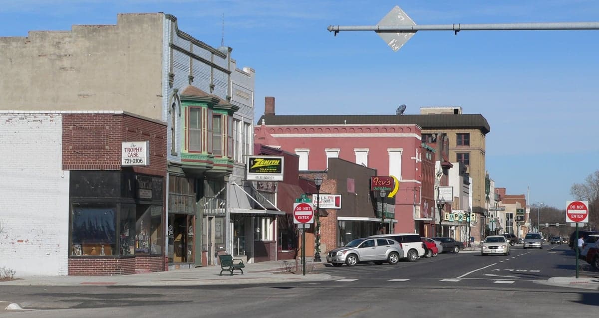
Photo: Wikipedia
Strategic Assessment of Fremont, NE
Meaningful friction. Expect exposure to either population pressure, blast zones, or natural disaster risk. Consider buying a retreat property.
What does the Strategic Assessment tell us?
Our Strategic Assessment grades tactical survivability of an area. Major population centers, military targets, fallout zones, natural disasters, and border exposure all drive risk — lower exposure means a more defensible position in a crisis.
This is heavily inspired by Joel Skousen's Strategic Relocation book. Highly recommended you checkout the book ($)What does this tell us?
Our Strategic Assessment grades tactical survivability of an area. Major population centers, military targets, fallout zones, natural disasters, and border exposure all drive risk — lower exposure means a more defensible position in a crisis.
This is heavily inspired by Joel Skousen's Strategic Relocation book. Highly recommended you checkout the book ($)Strategic Pillars

Key Distances
Regional Safe Places
Below is our recommended "safe zones" in Nebraska and the surrounding area based on our strategic heuristics. For most people, it's unrealistic to live in a “safe zone” full-time due to work, family or other personal reasons. They tend to be more rural. However, many of these areas are perfect for second homes and retreat properties that double as a vacation home or even a short-term rental.
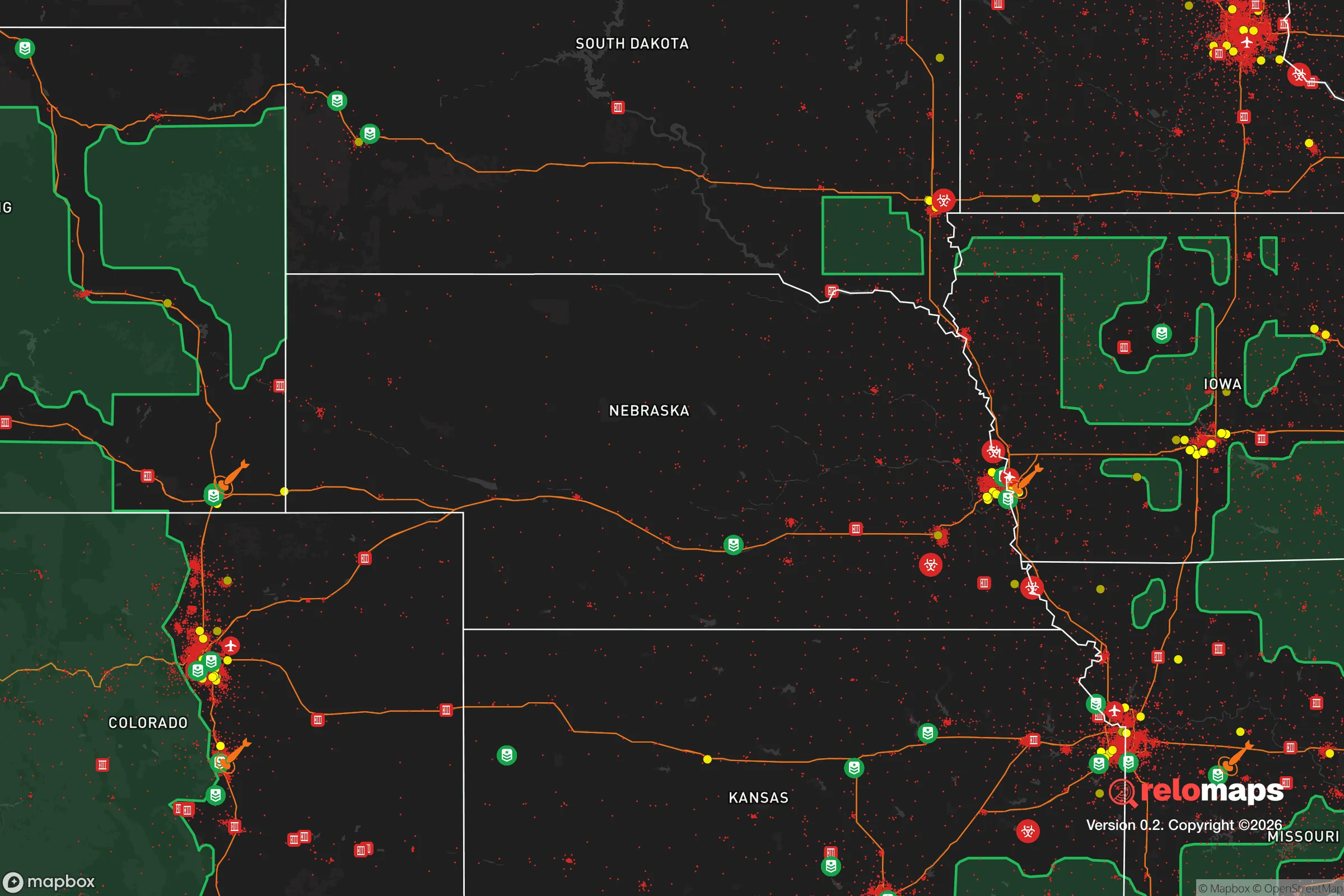
Important Note: For informational purposes only. This does not mean nothing bad ever happens in the green zones. Please use common sense. This is based on public data and modeled with AI. We tried to take a conservative approach but mistakes happen. We update this regularly as new information becomes available.
Solar Generator Recommendations
Backup power matters more here than in safer locations. We've picked three solar generators across budgets and capacity tiers — start with the budget unit if you only need a few essentials, or step up if you want to run a fridge and HVAC for days at a time.

Jackery Portable Power Station Explorer 300
Budget OptionPower on the Go: Weighing only 11 lbs, it's convenient to set up and store with book-sized foldable solar panels

BLUETTI Portable Power Station AC180
Designed for both indoor and outdoor scenarios, AC180 is highly capable as it has a robost capacity and continuous output power.

EF ECOFLOW DELTA Pro Ultra Power Station
Upgraded PickEcoFlow DELTA Pro Ultra is a whole-home energy system designed to grow with your family. Integrated with the Smart Home Panel 2, it scales to meet your evolving energy needs — keeping your home powered, intelligent, and secure through every stage of life.
We earn a commission, at no additional cost to you.
Strategic Assessment Analysis
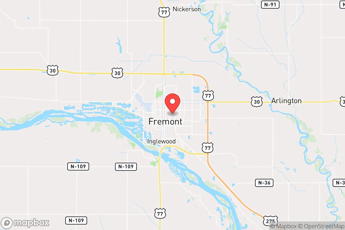
Fremont, Nebraska, sits in a strategic sweet spot that resilience-minded relocators should take seriously: close enough to Omaha and Lincoln to access their resources, but far enough to avoid being caught in the blast radius of a major urban collapse. The city’s position along the Platte River and its agricultural backbone give it a structural advantage that most suburbs simply don’t have. For those thinking in terms of long-term stability, food security, and geographic buffer, Fremont offers a rare combination of proximity and separation that makes it worth a hard look.
Geographic position and natural advantages for long-term stability
Fremont sits roughly 35 miles northwest of Omaha and 45 miles north of Lincoln, placing it outside the immediate fallout zone of a major event in either city. The Platte River runs along the southern edge of town, providing a reliable freshwater source and irrigation capacity that most Plains towns can’t match. The surrounding terrain is flat, open farmland—not ideal for concealment, but excellent for visibility, agriculture, and defensive positioning. The area’s elevation is modest, around 1,200 feet, but the lack of significant floodplain development means most of the city is safe from the river’s occasional spring surges. The local climate is classic Nebraska: hot summers, cold winters, and enough precipitation to support dryland farming without relying on complex irrigation infrastructure. For a relocator thinking about self-sufficiency, the soil here is productive, and the growing season—roughly 150 days—is long enough for staple crops like corn, beans, and squash.
Risks, exposures, and proximity to fallout-relevant landmarks
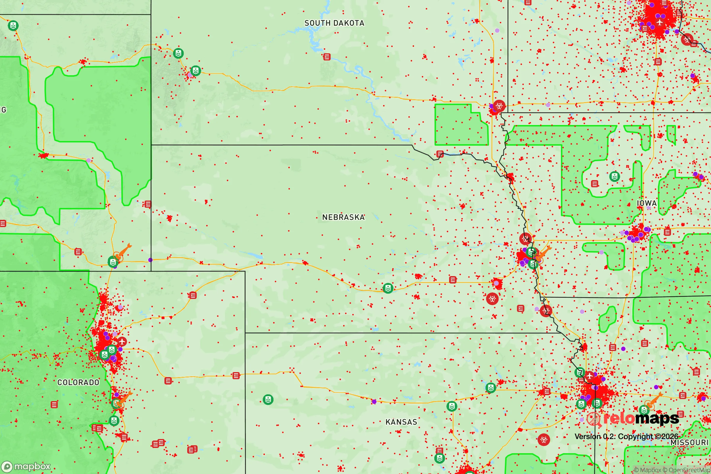
No location is without exposure, and Fremont has a few that demand attention. The city lies within 50 miles of Offutt Air Force Base near Omaha, a major strategic command center that would be a high-priority target in any conflict involving strategic weapons. A ground burst at Offutt would put Fremont in the moderate fallout zone, with dangerous radiation levels lasting days to weeks depending on wind direction. The same logic applies to the Union Pacific rail yards and the interstate highway corridors that run through the region—these are choke points that could become contested or disrupted during civil unrest. On the plus side, Fremont itself hosts no major military installations, no large-scale chemical plants, and no nuclear power facilities. The nearest nuclear plant, Fort Calhoun, is about 30 miles east and has been decommissioned, removing one major risk vector. The biggest practical exposure is the city’s reliance on a single major highway, U.S. Route 30, and the fact that the surrounding farmland offers little natural cover for movement during a crisis. For a relocator, the key takeaway is that Fremont is not a primary target, but it sits close enough to primary targets that a pre-planned evacuation route and a well-stocked shelter are non-negotiable.
Practical resilience for a relocator: food, water, energy, and defensibility
Fremont’s agricultural economy is its strongest resilience asset. The city is surrounded by working farms and ranches, and the local food supply chain is robust even in normal times. The Fremont area produces corn, soybeans, beef, and dairy at scale, meaning that a relocator with the right connections—or the right land—can tap into local food networks without relying on national grocery distribution. Water access is straightforward: the Platte River is a perennial source, and the local aquifer is shallow and productive. Most homes in the area have private wells or are on municipal systems that draw from groundwater, not surface reservoirs that could be contaminated or drained. Energy infrastructure is a mixed bag. The grid is served by the Nebraska Public Power District, which relies heavily on coal and natural gas, with some wind generation. Solar potential is decent—Nebraska averages about 4.5 peak sun hours per day—but the state’s regulatory environment is not particularly friendly to off-grid solar setups, so a relocator should plan for battery backup and generator redundancy. Defensibility is where Fremont shows its limits. The city is spread out, with no natural barriers like hills or forests to slow an approaching threat. The downtown core is compact and walkable, but the residential areas are typical suburban sprawl. For a single individual or a family, the best approach is to secure a property on the outskirts—preferably with a well, a garden plot, and a clear line of sight to the nearest road. The local law enforcement presence is adequate for day-to-day issues, but in a widespread crisis, residents would largely be on their own. The community itself is tight-knit and conservative, which cuts both ways: neighbors will help, but outsiders will be viewed with suspicion until trust is earned.
The overall strategic picture for Fremont is one of cautious optimism. It offers the kind of buffer that preppers value—close enough to urban centers for supply runs and medical access, far enough to avoid the worst of a collapse. The agricultural base, water access, and low target profile make it a solid choice for someone who wants to be prepared without going completely off-grid. The downsides are real: proximity to a major military target, limited natural cover, and a reliance on a single highway for evacuation. But for a conservative-leaning relocator who values community, self-reliance, and a slower pace of life, Fremont checks more boxes than most places in the region. The key is to arrive with a plan, not just a hope—stock supplies, build local relationships, and treat the city as a base of operations rather than a fortress. In a world where the next crisis is always just around the corner, Fremont gives you a fighting chance.
* Values derived from national, state, county, city and local statistics and may differ in a specific area. Last updated: 2026-04-21T15:09:28.000Z
Narrative content on this page is AI-generated and may contain mistakes. Verify any details that matter before acting on them.
ReloMaps may earn a commission from affiliate links at no extra cost to you.