Photo: Wikipedia
Strategic Assessment of Boulder County
Meaningful friction. Expect exposure to either population pressure, blast zones, or natural disaster risk. Consider buying a retreat property.
What does the Strategic Assessment tell us?
Our Strategic Assessment grades tactical survivability of an area. Major population centers, military targets, fallout zones, natural disasters, and border exposure all drive risk — lower exposure means a more defensible position in a crisis.
This is heavily inspired by Joel Skousen's Strategic Relocation book. Highly recommended you checkout the book ($)What does this tell us?
Our Strategic Assessment grades tactical survivability of an area. Major population centers, military targets, fallout zones, natural disasters, and border exposure all drive risk — lower exposure means a more defensible position in a crisis.
This is heavily inspired by Joel Skousen's Strategic Relocation book. Highly recommended you checkout the book ($)Strategic Pillars

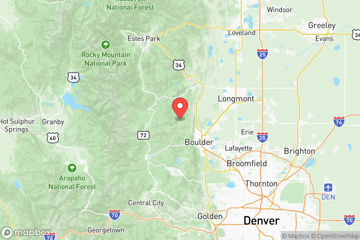
Key Distances
Strategic Assessment Analysis
Boulder County offers a complex strategic picture for relocation-minded readers who prioritize resilience and self-sufficiency. Its position at the eastern edge of the Rocky Mountains provides genuine geographic advantages—mountain barriers, high-altitude water sources, and distance from major coastal fallout zones—but these are balanced by proximity to the Denver metropolitan area, a major population and infrastructure hub that introduces its own set of risks and dependencies. For a family or individual weighing disaster readiness, Boulder County is neither a fortress nor a vulnerability; it is a high-value, moderate-risk zone that rewards careful site selection within its boundaries.
Geographic position and natural advantages for long-term resilience
Boulder County sits at the intersection of the Great Plains and the Front Range, with elevations ranging from roughly 5,000 feet in the city of Boulder to over 14,000 feet at the summit of Longs Peak in Rocky Mountain National Park. This vertical relief provides several strategic benefits. The mountains act as a natural barrier against prevailing westerly winds carrying airborne contaminants from distant sources, and the county's position east of the Continental Divide means it draws water from snowmelt in the Arapaho and Roosevelt National Forests rather than from the Colorado River system, which faces chronic drought and interstate allocation disputes. The county's major water source, Boulder Creek, originates high in the Indian Peaks Wilderness, giving residents a relatively secure, gravity-fed water supply that is less vulnerable to pumping failures or contamination from downstream agriculture. The city of Boulder itself sits at 5,430 feet, while smaller communities like Nederland (8,200 feet) and Ward (9,400 feet) offer even higher ground, though with correspondingly harsher winters and reduced growing seasons. The overall terrain provides numerous defensible positions—valley chokepoints, ridge-line properties with clear sightlines, and dispersed rural parcels in unincorporated areas like Gold Hill and Allenspark that are accessible only via narrow, winding roads.
Risks, exposures, and proximity to fallout-relevant landmarks
The most significant strategic liability for Boulder County is its proximity to the Denver-Aurora-Lakewood metropolitan area, home to roughly 3 million people. In a major disaster scenario—whether natural or man-made—the county would face pressure from population displacement out of Denver, which lies just 25 miles southeast of downtown Boulder. Interstate 25 and U.S. Highway 36 are the primary evacuation corridors, and both would likely become impassable during a crisis. The county also sits within 50 miles of several high-value infrastructure targets. The Rocky Flats National Wildlife Refuge, a former nuclear weapons production facility, is located just south of Boulder County in Jefferson County; while cleanup is complete, the site remains a psychological and logistical landmark for anyone assessing fallout risks. To the north, the Weld County energy corridor—including natural gas processing plants and the Pawnee Generating Station—presents industrial hazards. The Denver Federal Center in Lakewood, the U.S. Mint in Denver, and Buckley Space Force Base in Aurora are all within a 40-mile radius. For a reader concerned about electromagnetic pulse (EMP) or coordinated infrastructure attacks, the concentration of military and government assets along the Front Range is a notable negative. Wildfire risk is the most immediate natural hazard: the 2021 Marshall Fire destroyed over 1,000 homes in Boulder County, demonstrating that even suburban and semi-rural areas are vulnerable to fast-moving grass fires driven by downslope winds. Flooding along Boulder Creek and its tributaries is a recurring risk, particularly in the mountain canyons west of Boulder.
Practical resilience for a relocator: food, water, energy, and defensibility
For a relocator serious about self-sufficiency, Boulder County presents a mixed picture. Water security is a genuine strength: the county's municipal systems draw from high-altitude reservoirs like Barker Meadow and Gross Reservoir, both fed by snowmelt from protected wilderness areas. Private wells are common in unincorporated areas, with depths typically ranging from 100 to 400 feet, though drilling costs are high (often $15,000–$30,000) and yields can be variable in the foothills. Food production is limited by climate and terrain: the growing season in Boulder (elevation 5,430 feet) runs roughly May through September, with frost possible any month of the year. The county's agricultural land is concentrated in the eastern plains around Longmont and Hygiene, where irrigated cropland supports hay, corn, and some vegetable production. However, the county is a net food importer, and most grocery stock is trucked in from distribution centers in Denver and Aurora. Energy infrastructure is moderately resilient: Xcel Energy provides electricity via a grid that is vulnerable to wildfire shutoffs and winter storms, but solar adoption is high—Boulder County ranks among the top in the state for residential solar installations. Off-grid solar is feasible in the foothills, though winter generation drops significantly. Natural gas is widely available in the eastern half of the county but absent in many mountain communities, where propane delivery is the norm. Defensibility varies dramatically by location: a rural property in the foothills near Jamestown or Raymond offers natural chokepoints and limited access roads, but also isolation and long response times for emergency services. Suburban neighborhoods in Louisville or Superior offer community resources but are highly exposed to population movement along major highways. The county's strong land-use regulations and open-space preservation—over 100,000 acres of publicly accessible open space—provide buffer zones but also limit the ability to stockpile resources or fortify property without drawing attention.
The overall strategic picture for Boulder County is one of high potential tempered by real constraints. For a relocator who can secure a property with a private well, solar capacity, and defensible terrain in the foothills west of Boulder or near the rural communities of Hygiene or Allenspark, the area offers genuine advantages: clean water from protected watersheds, mountain barriers against airborne threats, and distance from the most concentrated fallout targets of the Denver metro. However, the county's popularity, high cost of living (median home price above $800,000), and strict building codes mean that true self-sufficiency requires significant capital and careful due diligence. For those willing to navigate these trade-offs, Boulder County represents a defensible, resource-rich position in a state that is itself a relative stronghold in continental U.S. resilience planning. For those seeking a simpler, lower-cost, or more isolated option, the county may be overpriced and overexposed. The decision hinges on whether the strategic benefits of the Front Range's water and terrain outweigh the risks of its population density and infrastructure concentration.
* Values derived from national, state, county, city and local statistics and may differ in a specific area. Last updated: 2026-06-08T18:37:48.000Z
Narrative content on this page is AI-generated and may contain mistakes. Verify any details that matter before acting on them.
ReloMaps may earn a commission from affiliate links at no extra cost to you.