
Photo: City of Casselton
Strategic Assessment of Casselton, ND
Workable tactical position. Some exposure to population density or targets, but generally defensible in a crisis.
What does the Strategic Assessment tell us?
Our Strategic Assessment grades tactical survivability of an area. Major population centers, military targets, fallout zones, natural disasters, and border exposure all drive risk — lower exposure means a more defensible position in a crisis.
This is heavily inspired by Joel Skousen's Strategic Relocation book. Highly recommended you checkout the book ($)What does this tell us?
Our Strategic Assessment grades tactical survivability of an area. Major population centers, military targets, fallout zones, natural disasters, and border exposure all drive risk — lower exposure means a more defensible position in a crisis.
This is heavily inspired by Joel Skousen's Strategic Relocation book. Highly recommended you checkout the book ($)Strategic Pillars

Key Distances
Regional Safe Places
Below is our recommended "safe zones" in North Dakota and the surrounding area based on our strategic heuristics. For most people, it's unrealistic to live in a “safe zone” full-time due to work, family or other personal reasons. They tend to be more rural. However, many of these areas are perfect for second homes and retreat properties that double as a vacation home or even a short-term rental.
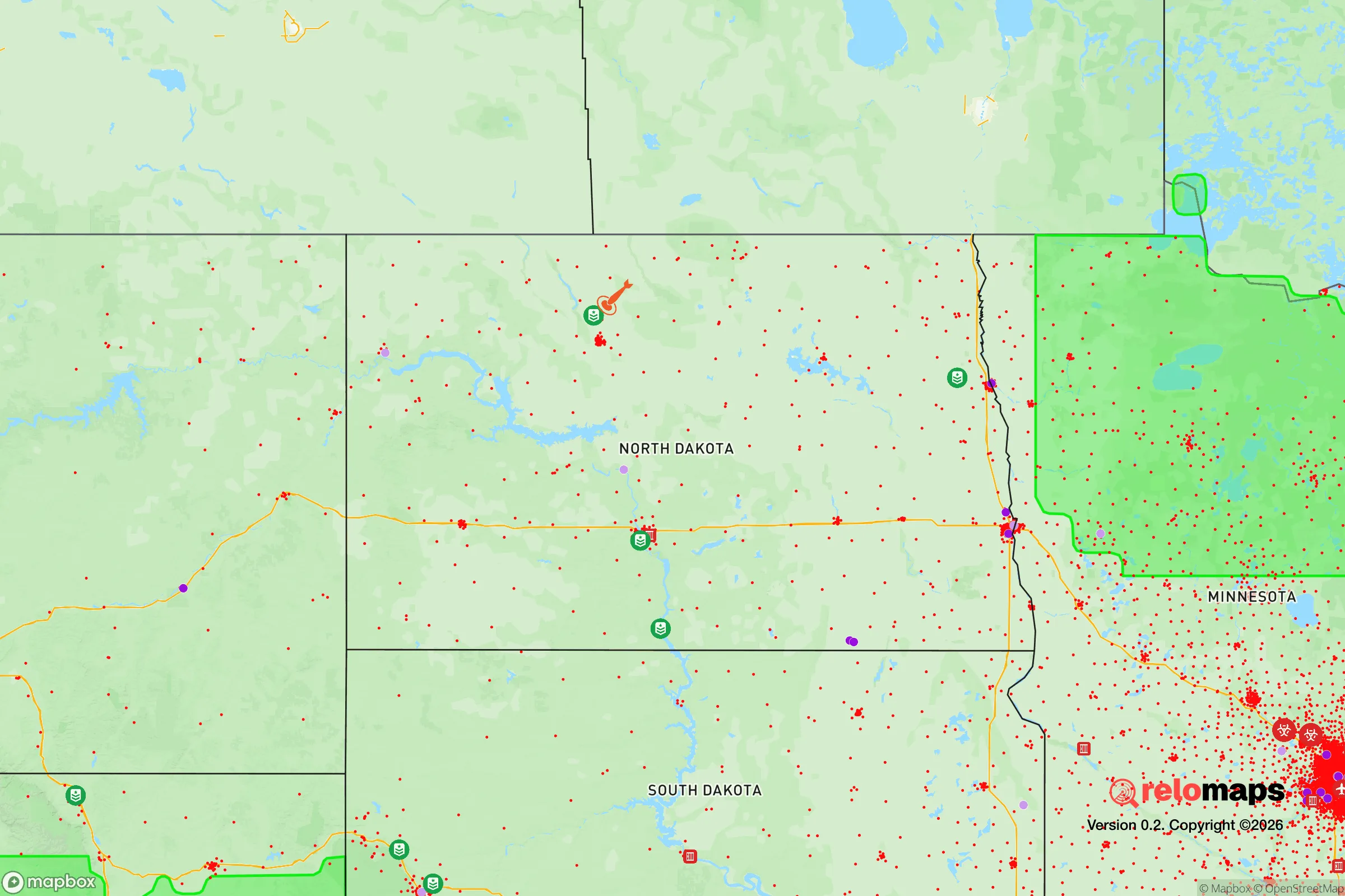
Important Note: For informational purposes only. This does not mean nothing bad ever happens in the green zones. Please use common sense. This is based on public data and modeled with AI. We tried to take a conservative approach but mistakes happen. We update this regularly as new information becomes available.
Solar Generator Recommendations
Backup power matters more here than in safer locations. We've picked three solar generators across budgets and capacity tiers — start with the budget unit if you only need a few essentials, or step up if you want to run a fridge and HVAC for days at a time.

Jackery Portable Power Station Explorer 300
Budget OptionPower on the Go: Weighing only 11 lbs, it's convenient to set up and store with book-sized foldable solar panels

BLUETTI Portable Power Station AC180
Designed for both indoor and outdoor scenarios, AC180 is highly capable as it has a robost capacity and continuous output power.

EF ECOFLOW DELTA Pro Ultra Power Station
Upgraded PickEcoFlow DELTA Pro Ultra is a whole-home energy system designed to grow with your family. Integrated with the Smart Home Panel 2, it scales to meet your evolving energy needs — keeping your home powered, intelligent, and secure through every stage of life.
We earn a commission, at no additional cost to you.
Strategic Assessment Analysis
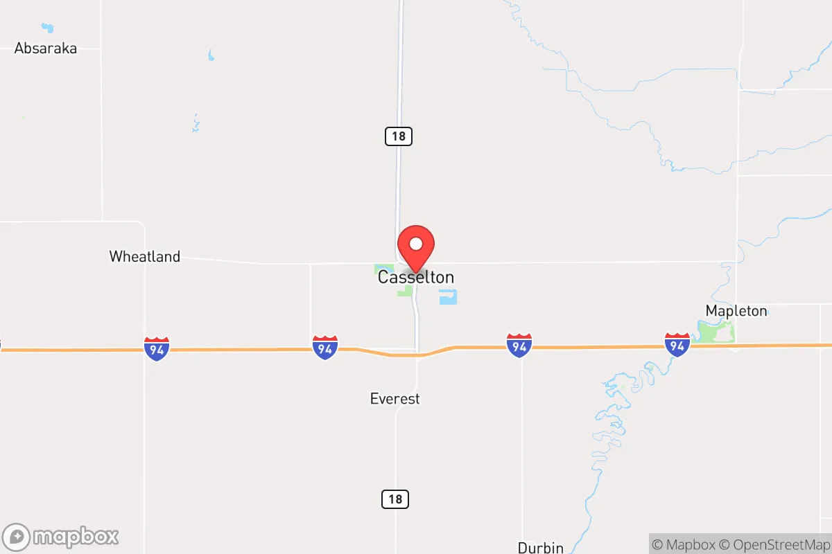
Casselton, North Dakota, sits in a sweet spot for those serious about resilience: far enough from major population centers to avoid the worst of any collapse, but close enough to Fargo (about 20 miles east) to access supplies and medical care when things are stable. Its position along Interstate 94 and the BNSF Railway gives it logistical advantages for both daily life and emergency movement, while the surrounding Red River Valley farmland offers a reliable food base. For a relocator thinking in terms of decades, not just the next election cycle, Casselton presents a low-profile, high-utility option that balances isolation with connectivity.
Geographic position and natural advantages for long-term security
Casselton’s location in Cass County places it in the heart of the Red River Valley, one of the most productive agricultural regions in North America. The flat, fertile soil supports massive grain and soybean operations, meaning local food production is not a hobby—it’s the economic backbone. The area’s low population density (Cass County has about 200,000 people, but most are clustered in Fargo) means you’re not competing with millions for resources. The Missouri River and the Red River drainage systems provide ample surface water, and the region’s shallow aquifer is accessible via private wells, which is a critical advantage if municipal systems fail. Winters are harsh, with average January lows around -2°F, but that cold itself is a defensive asset: it discourages transient populations and slows the spread of disease. The flat terrain makes line-of-sight communication and observation easy, and the lack of dense forest means fewer places for threats to hide. For a prepper, this is a landscape you can read and control.
Risks, exposures, and proximity to fallout-relevant landmarks
The biggest risk in Casselton is its proximity to Fargo, which at 20 miles east is close enough that a major urban collapse—civil unrest, pandemic, or economic breakdown—could spill over. Fargo’s population of about 130,000, plus the surrounding metro area, means you’d see refugee flows along I-94 if things go south. Casselton itself is a small town of roughly 2,500 people, so it lacks the anonymity and resources of a larger city, but that also means fewer eyes on your operations. The BNSF Railway running through town is a double-edged sword: it’s a supply line for goods, but also a target for sabotage or a vector for hazardous material spills (the 2013 crude oil train derailment and fire here is a real-world example). There are no nuclear power plants within 100 miles, but the nearby Grand Forks Air Force Base (about 70 miles north) and the Fargo Air National Guard Base could become targets in a conflict. The Red River floods regularly—major floods in 1997, 2009, and 2011—so any property near the river or its tributaries needs elevation or flood-proofing. Tornadoes are a seasonal risk, though the flat terrain gives ample warning time. Overall, Casselton’s risks are manageable if you plan for them, but the Fargo proximity is the one factor that could turn a bad situation worse.
Practical resilience for a relocator: food, water, energy, and defensibility
For a relocator serious about self-sufficiency, Casselton offers a strong foundation. Food: The surrounding farmland means you can buy directly from local producers—grain, beef, pork, and vegetables are abundant. The Cass County Farmers Market in Fargo is a good resource, but building relationships with local farmers before a crisis is key. Water: The shallow aquifer is accessible via private wells, and the Red River is a backup source, though it requires filtration and treatment. Rainwater collection is viable, with average annual precipitation around 22 inches. Energy: North Dakota is the second-largest oil-producing state in the U.S., so fuel is cheap and available—but that also means the region is tied to global energy markets. Solar is less effective here due to long winters and short daylight hours, but wind is constant; small wind turbines are a practical investment. The grid is reliable in normal times, but a major EMP or cyberattack could knock it out for weeks. Defensibility: Casselton’s small size and rural layout make it hard to infiltrate unnoticed. The town has a police department and is near the Cass County Sheriff’s Office, but in a breakdown, you’d rely on your own network. The flat terrain means you can see threats from miles away, and the lack of natural cover makes ambushes difficult. The local gun culture is strong—North Dakota is a constitutional carry state—so you won’t stand out by being armed. The biggest defensive weakness is the I-94 corridor: it’s a highway for both resupply and invasion. A well-placed roadblock or observation post on the interstate could control movement, but that also makes you a target. The best strategy is to live slightly off the main roads, in a rural homestead with a clear field of fire and multiple escape routes.
The overall strategic picture for Casselton is one of cautious optimism for the prepared relocator. It’s not a bug-out location in the mountains, but a working-class town with real agricultural and logistical assets. The Fargo proximity is the main liability, but it also gives you access to medical care, hardware stores, and a larger community of like-minded people if you network carefully. The climate is brutal, the flood risk is real, and the railway is a wildcard, but these are known variables you can mitigate with planning and investment. For a conservative-leaning individual or family looking to weather the next decade of instability, Casselton offers a low-cost, high-resilience base that doesn’t scream “prepper” to the neighbors. The key is to integrate into the local community, build relationships with farmers and tradesmen, and keep a low profile. In a world where the cities are the powder kegs, Casselton is the solid ground a few miles back from the blast.
* Values derived from national, state, county, city and local statistics and may differ in a specific area. Last updated: 2026-04-19T05:58:16.000Z
Narrative content on this page is AI-generated and may contain mistakes. Verify any details that matter before acting on them.
ReloMaps may earn a commission from affiliate links at no extra cost to you.