
Photo: Wikipedia
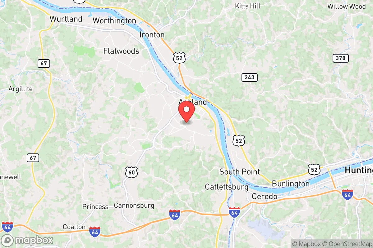
Strategic Assessment of Ashland, KY
Meaningful friction. Expect exposure to either population pressure, blast zones, or natural disaster risk. Consider buying a retreat property.
What does the Strategic Assessment tell us?
Our Strategic Assessment grades tactical survivability of an area. Major population centers, military targets, fallout zones, natural disasters, and border exposure all drive risk — lower exposure means a more defensible position in a crisis.
This is heavily inspired by Joel Skousen's Strategic Relocation book. Highly recommended you checkout the book ($)What does this tell us?
Our Strategic Assessment grades tactical survivability of an area. Major population centers, military targets, fallout zones, natural disasters, and border exposure all drive risk — lower exposure means a more defensible position in a crisis.
This is heavily inspired by Joel Skousen's Strategic Relocation book. Highly recommended you checkout the book ($)Strategic Pillars

Key Distances
Regional Safe Places
Below is our recommended "safe zones" in Kentucky and the surrounding area based on our strategic heuristics. For most people, it's unrealistic to live in a “safe zone” full-time due to work, family or other personal reasons. They tend to be more rural. However, many of these areas are perfect for second homes and retreat properties that double as a vacation home or even a short-term rental.


Important Note: For informational purposes only. This does not mean nothing bad ever happens in the green zones. Please use common sense. This is based on public data and modeled with AI. We tried to take a conservative approach but mistakes happen. We update this regularly as new information becomes available.
Solar Generator Recommendations
Backup power matters more here than in safer locations. We've picked three solar generators across budgets and capacity tiers — start with the budget unit if you only need a few essentials, or step up if you want to run a fridge and HVAC for days at a time.

Jackery Portable Power Station Explorer 300
Budget OptionPower on the Go: Weighing only 11 lbs, it's convenient to set up and store with book-sized foldable solar panels

BLUETTI Portable Power Station AC180
Designed for both indoor and outdoor scenarios, AC180 is highly capable as it has a robost capacity and continuous output power.

EF ECOFLOW DELTA Pro Ultra Power Station
Upgraded PickEcoFlow DELTA Pro Ultra is a whole-home energy system designed to grow with your family. Integrated with the Smart Home Panel 2, it scales to meet your evolving energy needs — keeping your home powered, intelligent, and secure through every stage of life.
We earn a commission, at no additional cost to you.
Strategic Assessment Analysis
Ashland, Kentucky, sits as a surprisingly resilient pocket in the eastern edge of the state, offering a strategic blend of geographic isolation and practical self-sufficiency that appeals to those thinking about long-term preparedness. While not a major population hub, its position along the Ohio River and its distance from the most volatile urban centers make it a viable relocation target for individuals and families who prioritize security, resource access, and a lower profile. The area’s industrial past, including a still-active steel mill and chemical plants, provides both economic backbone and potential vulnerabilities, but for the prepper-minded relocator, Ashland’s overall strategic picture is one of moderate defensibility with clear trade-offs.
Geographic position and natural advantages for long-term security
Ashland’s location in Boyd County, hard against the Ohio River and the West Virginia border, places it in a corridor that has historically been a transportation and industrial artery. The river itself is a major asset: it provides a reliable water source, a potential route for movement or supply, and a natural barrier to the north. The surrounding terrain is hilly and wooded, part of the Appalachian foothills, which offers some natural concealment and makes large-scale mechanized movement difficult. The area is roughly 140 miles from Cincinnati, 160 miles from Lexington, and 200 miles from Columbus, placing it outside the immediate blast radius or fallout zones of any major city. For someone concerned with civil unrest or mass casualty events, that buffer is meaningful. The local climate is temperate with four distinct seasons, supporting subsistence gardening and small-scale agriculture, though the growing season is shorter than in the South. The Ohio River Valley also has ample groundwater, and many rural properties in the surrounding county still rely on wells, which is a significant advantage if municipal systems are compromised.
Risks, exposures, and proximity to fallout-relevant landmarks
No location is without risk, and Ashland has several that a strategic relocator must weigh. The most obvious is the presence of the Marathon Petroleum refinery in nearby Catlettsburg, one of the largest on the East Coast, and the AK Steel mill in Ashland itself. These are high-value industrial targets in any conflict scenario, and their proximity means that a precision strike or major accident could create a localized disaster zone. The Ohio River also carries barge traffic of hazardous materials, including ammonia and chlorine, which are stored at various points along the river. A derailment or barge breach could release a toxic cloud that drifts into Ashland. Additionally, the area is in a moderate seismic zone—the New Madrid fault is far to the west, but the region does experience occasional tremors. Flooding is a real concern for low-lying areas near the river; the 1997 flood and more recent high-water events have shown that the floodplain is not immune. For fallout from a nuclear event, Ashland’s prevailing winds generally come from the west and southwest, so a strike on Cincinnati or Lexington would put the area in a downwind plume, though the distance would reduce intensity. The closest major nuclear power plant is the Perry Nuclear Plant in Ohio, about 150 miles north, which is far enough to be a secondary concern but worth noting for worst-case planning.
Practical resilience for a relocator: food, water, energy, and defensibility
For the individual or family looking to establish a resilient household, Ashland offers a mixed but workable baseline. Local food production is feasible: the soil in the surrounding hills is thin and rocky in places, but the river bottoms and many residential lots can support vegetable gardens, and there is a strong tradition of home canning and hunting in the region. Deer are abundant, and small game is present. The local farmers’ market operates seasonally, and there are several grocery chains, but a prepper should not rely solely on supply chains. Water is the stronger asset: the Ohio River is a massive, year-round source, though it requires filtration and treatment. Many homes in the county have private wells, and those in town are on municipal water drawn from the river. For energy, the grid is reasonably stable but aging; coal and natural gas plants in the region provide baseload power, but outages from storms or ice are common in winter. Solar is viable but not optimal due to the region’s cloud cover and tree canopy; a backup generator with stored fuel is a more practical investment. Defensibility is moderate: the town itself is compact and walkable, with a mix of older neighborhoods and newer subdivisions. The hills and hollows to the south and east offer more secluded properties with limited access roads, which is ideal for those who want to avoid being funneled into a single choke point. The local population is aging and shrinking, which means fewer people to compete with for resources in a crisis, but also a thinner social fabric for mutual aid. Gun ownership is common and legal, with Kentucky being a constitutional carry state, so the cultural environment is favorable for those who prioritize self-defense. The local law enforcement presence is adequate but not overwhelming; the Ashland Police Department and Boyd County Sheriff’s Office are professional but small, and in a widespread event, they would be stretched thin.
The overall strategic picture for Ashland is that of a secondary-tier relocation target: not the most remote or self-sufficient location in the country, but one that offers a realistic balance of access, resources, and low profile for someone who wants to be prepared without living off-grid in a bunker. Its industrial assets are a double-edged sword—they provide local jobs and infrastructure but also create target risks. The river is a lifeline and a hazard. The surrounding terrain offers cover and isolation but also limits agricultural potential. For a conservative-leaning individual or family who values community, self-reliance, and a slower pace of life, Ashland is worth a serious look. It is not a fortress, but it is a place where a prepared person can build a sustainable existence with reasonable odds of weathering the storms ahead. The key is to arrive with eyes open, secure a property with good water and defensible access, and integrate into the local network of like-minded residents who already understand the value of being ready.
* Values derived from national, state, county, city and local statistics and may differ in a specific area. Last updated: 2026-04-21T09:16:49.000Z
Narrative content on this page is AI-generated and may contain mistakes. Verify any details that matter before acting on them.
ReloMaps may earn a commission from affiliate links at no extra cost to you.