
Photo: Wikipedia
Strategic Assessment of Altoona, PA
Meaningful friction. Expect exposure to either population pressure, blast zones, or natural disaster risk. Consider buying a retreat property.
What does the Strategic Assessment tell us?
Our Strategic Assessment grades tactical survivability of an area. Major population centers, military targets, fallout zones, natural disasters, and border exposure all drive risk — lower exposure means a more defensible position in a crisis.
This is heavily inspired by Joel Skousen's Strategic Relocation book. Highly recommended you checkout the book ($)What does this tell us?
Our Strategic Assessment grades tactical survivability of an area. Major population centers, military targets, fallout zones, natural disasters, and border exposure all drive risk — lower exposure means a more defensible position in a crisis.
This is heavily inspired by Joel Skousen's Strategic Relocation book. Highly recommended you checkout the book ($)Strategic Pillars

Key Distances
Regional Safe Places
Below is our recommended "safe zones" in Pennsylvania and the surrounding area based on our strategic heuristics. For most people, it's unrealistic to live in a “safe zone” full-time due to work, family or other personal reasons. They tend to be more rural. However, many of these areas are perfect for second homes and retreat properties that double as a vacation home or even a short-term rental.


Important Note: For informational purposes only. This does not mean nothing bad ever happens in the green zones. Please use common sense. This is based on public data and modeled with AI. We tried to take a conservative approach but mistakes happen. We update this regularly as new information becomes available.
Solar Generator Recommendations
Backup power matters more here than in safer locations. We've picked three solar generators across budgets and capacity tiers — start with the budget unit if you only need a few essentials, or step up if you want to run a fridge and HVAC for days at a time.

Jackery Portable Power Station Explorer 300
Budget OptionPower on the Go: Weighing only 11 lbs, it's convenient to set up and store with book-sized foldable solar panels

BLUETTI Portable Power Station AC180
Designed for both indoor and outdoor scenarios, AC180 is highly capable as it has a robost capacity and continuous output power.

EF ECOFLOW DELTA Pro Ultra Power Station
Upgraded PickEcoFlow DELTA Pro Ultra is a whole-home energy system designed to grow with your family. Integrated with the Smart Home Panel 2, it scales to meet your evolving energy needs — keeping your home powered, intelligent, and secure through every stage of life.
We earn a commission, at no additional cost to you.
Strategic Assessment Analysis
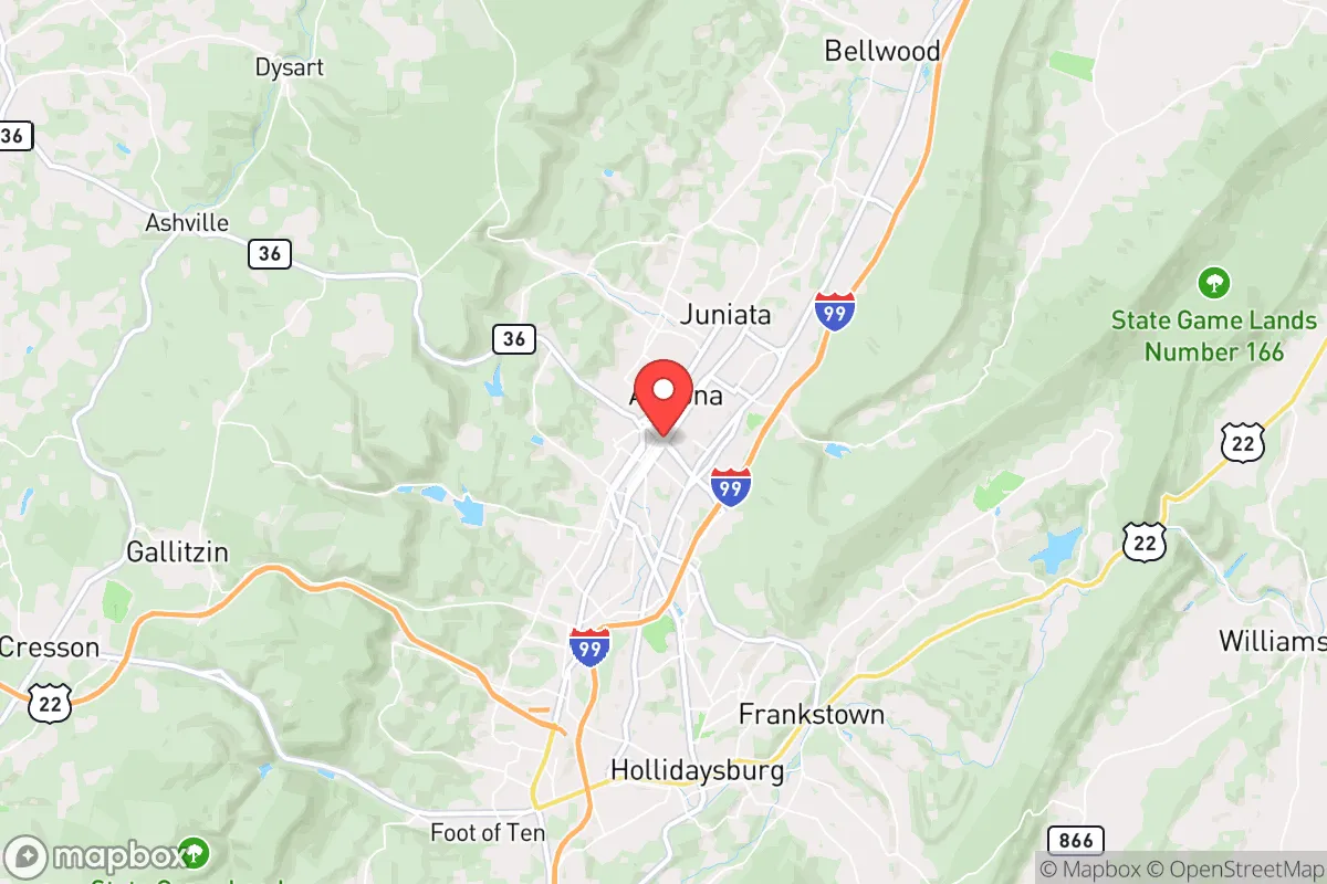
Altoona, Pennsylvania, sits in a geographic sweet spot that offers genuine strategic depth for those thinking long-term about resilience, but it comes with real trade-offs that demand clear-eyed assessment. Nestled in the Allegheny Mountains, this former railroad hub has weathered decades of economic decline and emerged as a low-cost, low-profile location that is far enough from major metropolitan targets to avoid the worst of fallout, yet close enough to access resources when needed. For a conservative-leaning relocator focused on preparedness—whether for civic unrest, economic collapse, or larger-scale disasters—Altoona presents a mixed bag: solid natural defenses and a self-reliant culture, but also proximity to infrastructure that could become a liability in a crisis.
Geographic position and natural advantages for long-term survival
Altoona’s location in Blair County, roughly 90 miles east of Pittsburgh and 120 miles west of Harrisburg, places it in a mountain valley that provides natural barriers against both human and environmental threats. The surrounding Allegheny Front and Tussey Mountain ridges create a bowl-like terrain that limits easy access from major highways, making the area inherently more defensible than flatter, open regions. The region sits atop the Appalachian Plateau, which means abundant freshwater sources—the Juniata River and its tributaries run through the area, and groundwater is generally reliable. The local climate is humid continental, with cold winters and moderate summers, which supports subsistence gardening and small-scale agriculture if you know what you’re doing. The elevation (roughly 1,200 feet) also reduces the risk of flooding compared to lower-lying areas, though flash flooding in narrow valleys is still a concern. For a prepper, the key advantage here is the combination of rugged terrain and low population density—Blair County has about 120,000 people spread over 527 square miles, meaning you’re not packed in like sardines. That translates to fewer competition points for resources in a collapse scenario, and more room to establish a self-sufficient homestead if you’re willing to put in the work.
Risks, exposures, and proximity to fallout-relevant landmarks
Here’s where the analysis gets sobering. Altoona is not a fallout-free zone. The area is within a 100-mile radius of several high-value targets that would be primary or secondary in a major conflict or terrorist event. Pittsburgh, with its steel mills, nuclear research facilities (Bettis Atomic Power Laboratory), and major transportation hubs, is close enough that a ground burst or airburst could send fallout plumes eastward depending on wind patterns. Similarly, the Harrisburg area, which includes the Three Mile Island nuclear plant (still in decommissioning but with spent fuel on-site), is a potential radiological hazard. The Pennsylvania Turnpike and I-99/I-80 corridors run through or near Altoona, making it a potential chokepoint for military or refugee movement during unrest. On the plus side, there are no major military bases, nuclear weapons storage sites, or chemical plants within 30 miles—the closest significant target is the Johnstown flood control infrastructure, which is more of a natural hazard than a strategic one. The real risk is that Altoona’s position as a rail and highway junction could make it a funnel for displaced populations from the East Coast during a crisis. The city itself has a population of about 43,000, but the surrounding rural areas offer better buffer zones. If you’re looking at Altoona as a bug-out location, you need to factor in that the valley geography could trap fallout or smoke from wildfires (which are increasing in frequency due to drought cycles). The bottom line: Altoona is not a hardened bunker location, but it’s far better than being in the blast radius of a major city.
Practical resilience for a relocator: food, water, energy, and defensibility
For day-to-day preparedness, Altoona offers a mix of strengths and weaknesses. Water is the biggest win—the area has multiple streams, springs, and wells, and the local water table is generally high enough that a hand-pump or solar-powered well can provide off-grid supply. The Juniata River is a reliable surface source, but you’ll need filtration or boiling due to agricultural runoff and potential industrial contamination from old rail yards. Food resilience is moderate: the growing season is short (about 150 frost-free days), but the soil in the valleys is decent for potatoes, root vegetables, and hardy greens. Local hunting for deer and turkey is legal and common, and the state game lands in the surrounding mountains provide a protein buffer. However, the area is not a breadbasket—you won’t be growing corn or wheat at scale without significant land and equipment. Energy is a mixed bag: grid reliability is average, with occasional outages from winter storms, but the mountainous terrain makes solar less efficient than in the Southwest. Wood heating is the most practical backup, and firewood is abundant if you have the land and labor. Defensibility is where Altoona shines for a prepared individual. The valley geography means you can control access points to a property with relative ease—a single road in and out is common for rural parcels. The local culture is still rooted in self-reliance, with a strong hunting and firearms tradition, which means you won’t stand out for owning weapons or storing supplies. The downside is that the local economy is weak (median household income around $45,000), so property crime and drug issues (opioids and meth) are present. You’ll need to secure your perimeter and build relationships with neighbors who share your mindset. The Amish and Mennonite communities in the surrounding counties (Mifflin, Huntingdon) are a resource for traditional skills and barter networks, but they keep to themselves—respect that boundary.
The overall strategic picture for Altoona is that it’s a solid B-tier relocation option for a conservative prepper who values low cost, natural barriers, and a self-reliant culture, but who is willing to accept proximity to some risk and a challenging climate. It’s not a remote mountain redoubt—you’re still within a few hours of major population centers, which is both a vulnerability and a convenience for supply runs or medical care in normal times. If you’re looking for a place to ride out a short-term crisis (weeks to months), Altoona’s infrastructure and community networks can support that. For a long-term collapse scenario (years), you’ll need to invest in off-grid water, food storage, and security upgrades, and you’ll want to be on the outskirts, not in the city proper. The real value here is that Altoona is overlooked—it’s not on the radar of most relocation guides, which means property prices are still reasonable (median home value around $100,000) and you can buy acreage without competing with waves of coastal refugees. If you’re serious about preparedness and you’re willing to trade glamour for grit, Altoona deserves a hard look. Just don’t expect it to be a paradise—it’s a working-class mountain town with real problems and real potential, and that’s exactly the kind of place that can work for someone who thinks ahead.
* Values derived from national, state, county, city and local statistics and may differ in a specific area. Last updated: 2026-05-01T08:07:23.000Z
Narrative content on this page is AI-generated and may contain mistakes. Verify any details that matter before acting on them.
ReloMaps may earn a commission from affiliate links at no extra cost to you.