Photo: Wikipedia
Strategic Assessment of Alexandria, KY
Meaningful friction. Expect exposure to either population pressure, blast zones, or natural disaster risk. Consider buying a retreat property.
What does the Strategic Assessment tell us?
Our Strategic Assessment grades tactical survivability of an area. Major population centers, military targets, fallout zones, natural disasters, and border exposure all drive risk — lower exposure means a more defensible position in a crisis.
This is heavily inspired by Joel Skousen's Strategic Relocation book. Highly recommended you checkout the book ($)What does this tell us?
Our Strategic Assessment grades tactical survivability of an area. Major population centers, military targets, fallout zones, natural disasters, and border exposure all drive risk — lower exposure means a more defensible position in a crisis.
This is heavily inspired by Joel Skousen's Strategic Relocation book. Highly recommended you checkout the book ($)Strategic Pillars

Key Distances
Regional Safe Places
Below is our recommended "safe zones" in Kentucky and the surrounding area based on our strategic heuristics. For most people, it's unrealistic to live in a “safe zone” full-time due to work, family or other personal reasons. They tend to be more rural. However, many of these areas are perfect for second homes and retreat properties that double as a vacation home or even a short-term rental.


Important Note: For informational purposes only. This does not mean nothing bad ever happens in the green zones. Please use common sense. This is based on public data and modeled with AI. We tried to take a conservative approach but mistakes happen. We update this regularly as new information becomes available.
Solar Generator Recommendations
Backup power matters more here than in safer locations. We've picked three solar generators across budgets and capacity tiers — start with the budget unit if you only need a few essentials, or step up if you want to run a fridge and HVAC for days at a time.

Jackery Portable Power Station Explorer 300
Budget OptionPower on the Go: Weighing only 11 lbs, it's convenient to set up and store with book-sized foldable solar panels

BLUETTI Portable Power Station AC180
Designed for both indoor and outdoor scenarios, AC180 is highly capable as it has a robost capacity and continuous output power.

EF ECOFLOW DELTA Pro Ultra Power Station
Upgraded PickEcoFlow DELTA Pro Ultra is a whole-home energy system designed to grow with your family. Integrated with the Smart Home Panel 2, it scales to meet your evolving energy needs — keeping your home powered, intelligent, and secure through every stage of life.
We earn a commission, at no additional cost to you.
Strategic Assessment Analysis
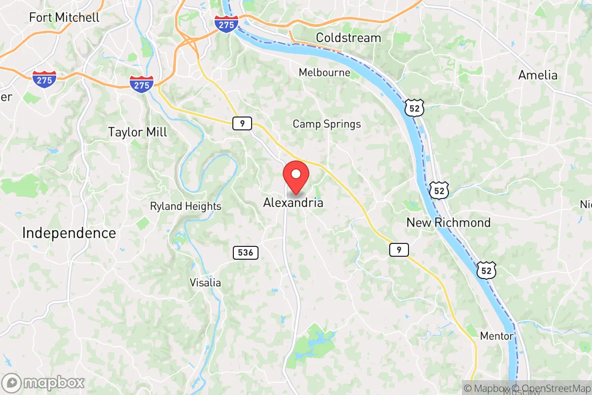
Alexandria, Kentucky, offers a compelling mix of strategic depth and practical vulnerability for the conservative prepper. Sitting just 15 miles from Cincinnati, it provides the economic and logistical benefits of a major metro area while maintaining a distinctly rural, small-town character that many find essential for long-term resilience. The key to understanding Alexandria's value is recognizing that its proximity to a major city is both its greatest asset and its most significant liability in a crisis scenario.
Geographic position and natural advantages for long-term survival
Alexandria sits atop the rolling hills of Campbell County, part of the Outer Bluegrass region. This is not flat, flood-prone bottomland. The terrain offers natural defensibility, with numerous ridges, hollows, and wooded areas that provide cover and concealment. The area is drained by the Licking River and its tributaries, which means reliable surface water sources are within a short drive or hike, though you'll want to treat it before drinking. The soil is generally fertile, supporting small-scale agriculture and gardening, a critical factor for food independence. The local climate is temperate, with four distinct seasons, allowing for a variety of crops and livestock, but also requiring preparation for winter storms and occasional ice events. The region's karst geology—limestone bedrock with caves and springs—means groundwater is abundant but also vulnerable to contamination from surface runoff, so a deep well or a reliable filtration system is non-negotiable. The area's position on the Ohio River corridor places it along a major transportation artery, which is a double-edged sword: it facilitates trade and resupply during normal times but also makes it a potential target or chokepoint during civil unrest or supply chain disruptions.
Risks, exposures, and proximity to fallout-relevant landmarks
The elephant in the room is Alexandria's proximity to Cincinnati. In a mass casualty event, civil unrest, or a major disaster, the city's population of over 300,000 will likely attempt to flee outward, and Alexandria is directly in the path of the most logical escape routes, particularly along US-27 and I-275. This creates a serious risk of being overrun by refugees, looters, or those seeking resources. The Cincinnati/Northern Kentucky International Airport (CVG), located just 10 miles west, is a major transportation hub that could become a focal point for evacuation, military operations, or, in a worst-case scenario, a target. The Ohio River itself is a strategic chokepoint; bridges and locks could be compromised or contested. The region also hosts several industrial facilities along the Ohio River, including chemical plants and power stations, which could become hazardous in a disaster. The nearby Fernald Feed Materials Production Center (a former uranium processing site, now a Superfund site) is a historical concern, though it's being remediated. More immediately, the area is within the 50-mile radius of the W.C. Beckjord Power Station (a coal plant) and the Zimmer Power Station, both of which could be targets or sources of secondary hazards. The risk of a major earthquake from the New Madrid Seismic Zone is low but not zero; a significant quake would devastate the Ohio River valley infrastructure. Tornadoes are a real threat, with the region sitting in the Ohio Valley's severe weather corridor. A direct hit on Alexandria would be catastrophic, given the town's limited emergency services capacity.
Practical resilience for a relocator: food, water, energy, and defensibility
For a relocator with a prepper mindset, Alexandria offers a mixed bag. Water is the primary concern. The municipal water supply comes from the Ohio River, which is vulnerable to contamination from upstream industrial accidents, terrorist attacks, or natural disasters. A deep well on your property is the gold standard, but not all lots have suitable geology. Rainwater catchment is a viable backup, but you'll need significant storage capacity. Food production is feasible but requires work. The growing season runs roughly April to October, and you can raise chickens, goats, and even a small beef cow on a few acres. Local farmers' markets and the Campbell County Cooperative Extension Service offer resources for gardening and livestock. However, the area is not a major agricultural producer; you'll rely on supply chains for most staples. Energy resilience is moderate. Duke Energy provides electricity, and grid reliability is average for the Midwest. Solar is viable, but the region's cloud cover and tree canopy reduce efficiency. A backup generator with a propane or natural gas hookup is a wise investment. Wood heating is practical, as firewood is abundant and relatively cheap. Defensibility is terrain-dependent. A property on a ridge with a single access road is ideal. The local law enforcement presence is adequate for a small town, but response times in rural areas can be 15-30 minutes. The community is generally conservative and self-reliant, which means neighbors are likely to be armed and willing to help, but also that you should keep a low profile and avoid drawing attention to your supplies. The local hospital, St. Elizabeth Healthcare in nearby Edgewood, is a Level II trauma center, but in a widespread event, it will be overwhelmed quickly. Stockpiling medical supplies and training in basic emergency medicine is essential.
The overall strategic picture for Alexandria is one of calculated risk. It is not a remote bug-out location; it is a suburban-rural hybrid that offers a decent quality of life and a reasonable chance of weathering moderate disruptions. Its proximity to Cincinnati provides access to jobs, healthcare, and supplies during normal times, but that same proximity is a critical vulnerability in a major crisis. For the conservative prepper who wants to maintain a normal life while building resilience, Alexandria is a viable option—provided you secure your own water, energy, and food sources, and have a plan for the inevitable surge of people fleeing the city. The area's natural advantages—defensible terrain, water sources, and a conservative community—are real, but they are not a guarantee. This is a place for the prepared, not the complacent. If you are willing to invest in infrastructure, build relationships with like-minded neighbors, and maintain a low profile, Alexandria can serve as a solid base for riding out the storm. If you are looking for true isolation and zero risk, look further east into the Appalachian foothills. But for a balance of convenience and resilience, this area deserves serious consideration.
* Values derived from national, state, county, city and local statistics and may differ in a specific area. Last updated: 2026-04-21T18:44:37.000Z
Narrative content on this page is AI-generated and may contain mistakes. Verify any details that matter before acting on them.
ReloMaps may earn a commission from affiliate links at no extra cost to you.