Photo: Wikipedia
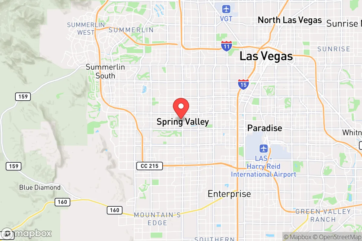
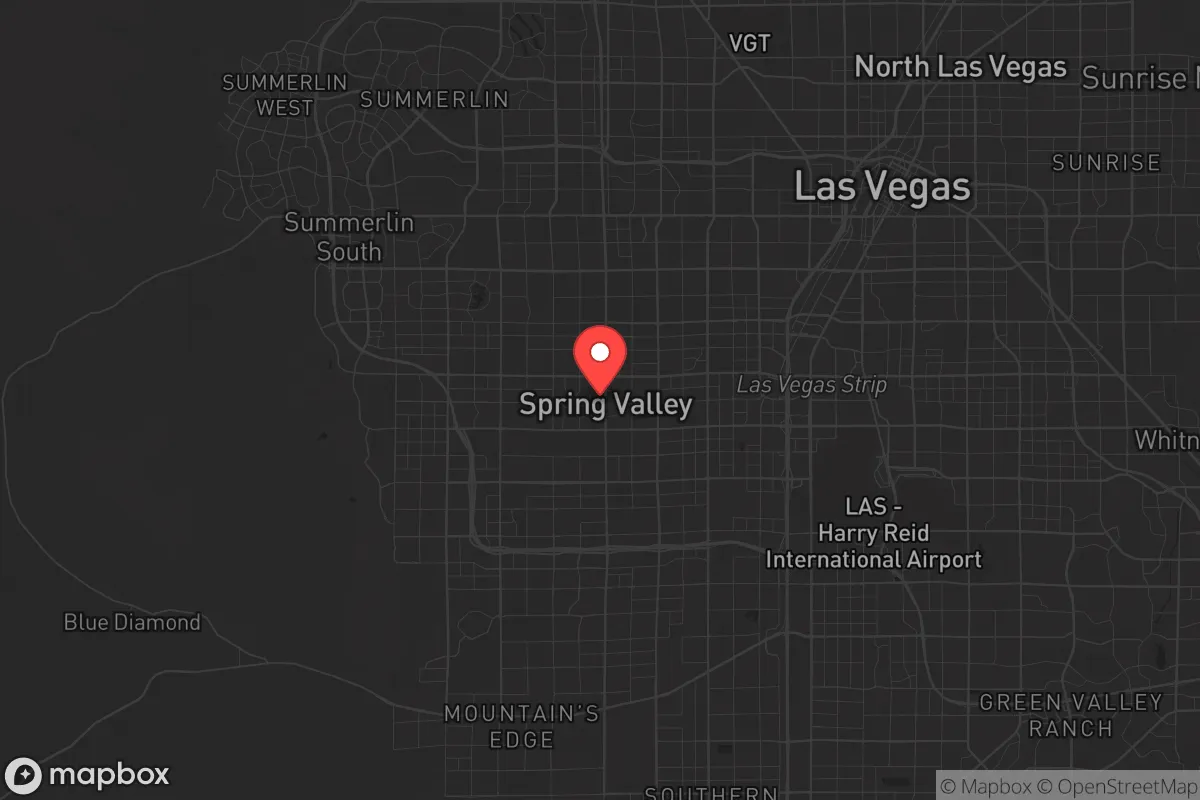
Strategic Assessment of Spring Valley, NV
Meaningful friction. Expect exposure to either population pressure, blast zones, or natural disaster risk. Consider buying a retreat property.
What does the Strategic Assessment tell us?
Our Strategic Assessment grades tactical survivability of an area. Major population centers, military targets, fallout zones, natural disasters, and border exposure all drive risk — lower exposure means a more defensible position in a crisis.
This is heavily inspired by Joel Skousen's Strategic Relocation book. Highly recommended you checkout the book ($)What does this tell us?
Our Strategic Assessment grades tactical survivability of an area. Major population centers, military targets, fallout zones, natural disasters, and border exposure all drive risk — lower exposure means a more defensible position in a crisis.
This is heavily inspired by Joel Skousen's Strategic Relocation book. Highly recommended you checkout the book ($)Strategic Pillars

Key Distances
Regional Safe Places
Below is our recommended "safe zones" in Nevada and the surrounding area based on our strategic heuristics. For most people, it's unrealistic to live in a “safe zone” full-time due to work, family or other personal reasons. They tend to be more rural. However, many of these areas are perfect for second homes and retreat properties that double as a vacation home or even a short-term rental.
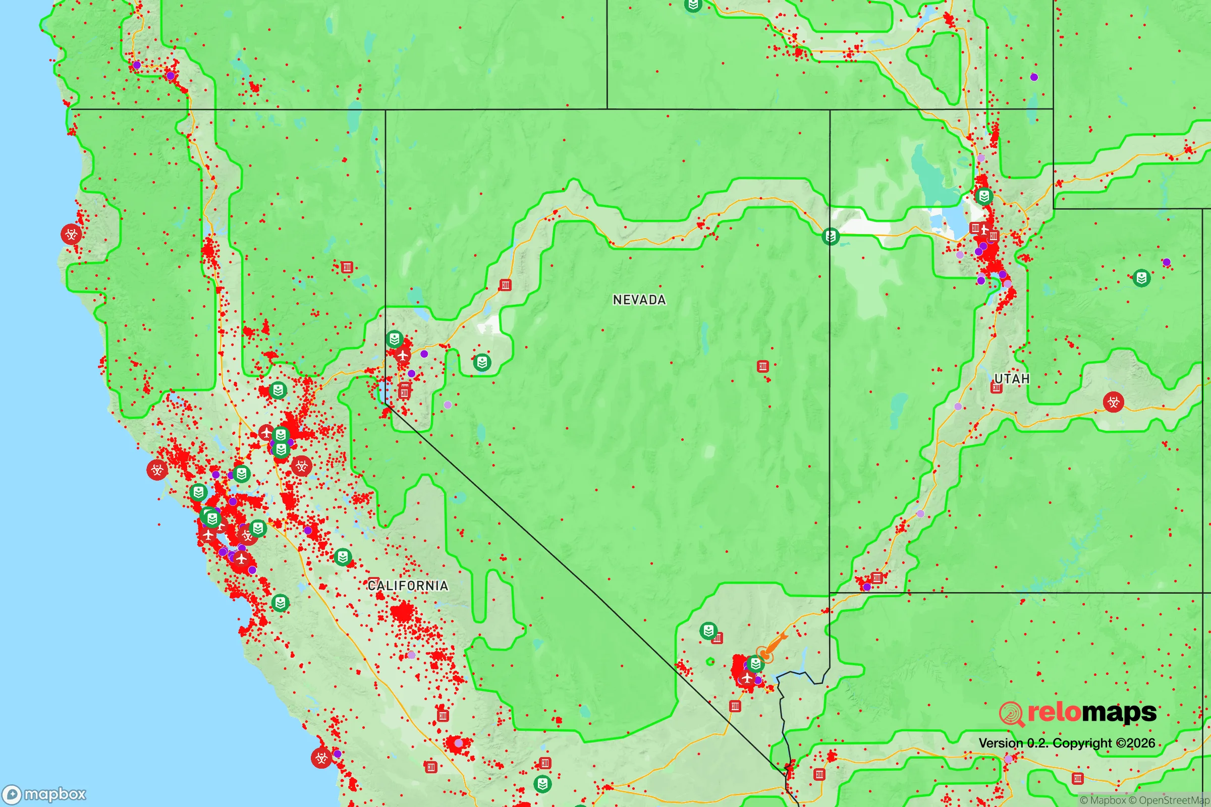
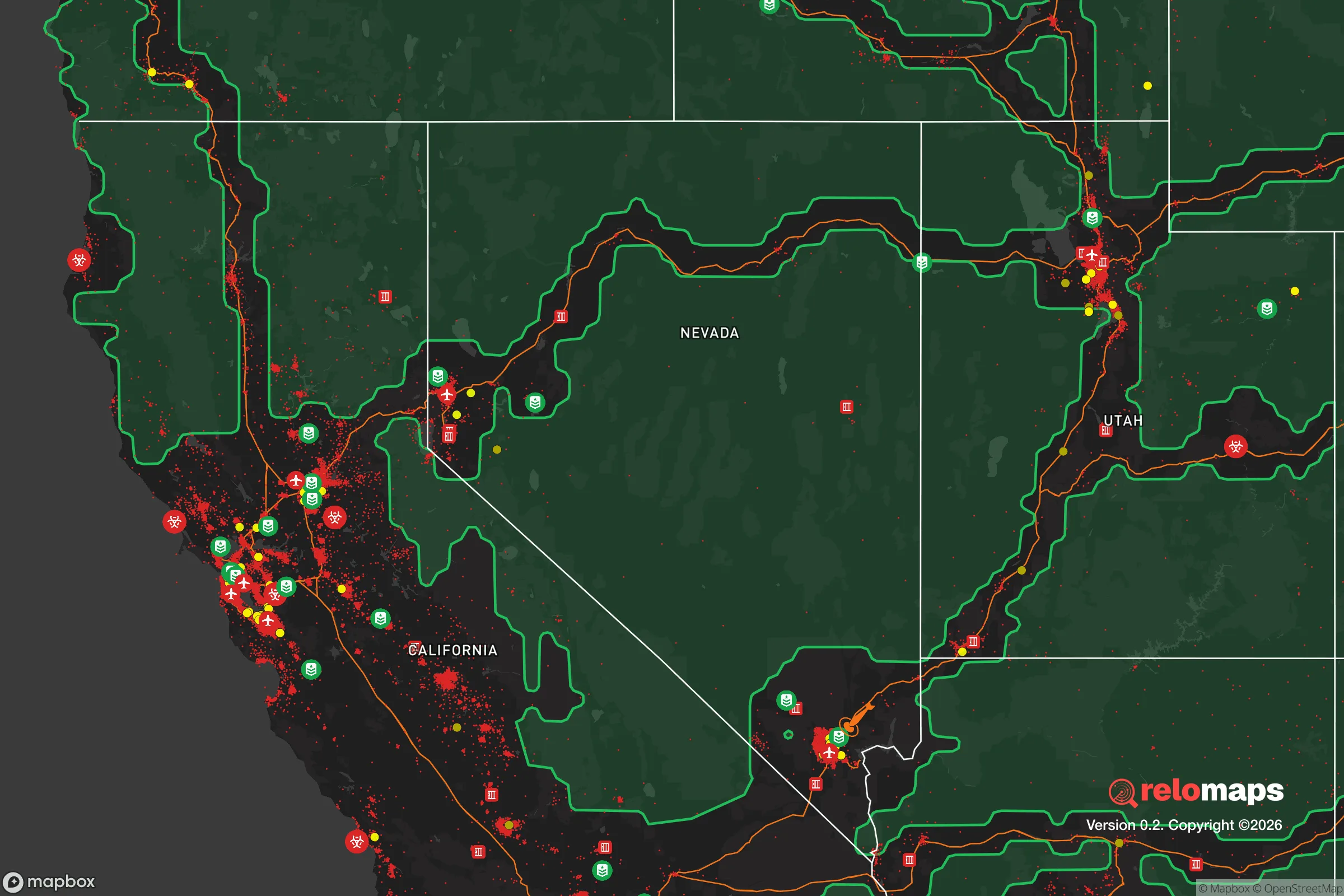
Important Note: For informational purposes only. This does not mean nothing bad ever happens in the green zones. Please use common sense. This is based on public data and modeled with AI. We tried to take a conservative approach but mistakes happen. We update this regularly as new information becomes available.
Solar Generator Recommendations
Backup power matters more here than in safer locations. We've picked three solar generators across budgets and capacity tiers — start with the budget unit if you only need a few essentials, or step up if you want to run a fridge and HVAC for days at a time.

Jackery Portable Power Station Explorer 300
Budget OptionPower on the Go: Weighing only 11 lbs, it's convenient to set up and store with book-sized foldable solar panels

BLUETTI Portable Power Station AC180
Designed for both indoor and outdoor scenarios, AC180 is highly capable as it has a robost capacity and continuous output power.

EF ECOFLOW DELTA Pro Ultra Power Station
Upgraded PickEcoFlow DELTA Pro Ultra is a whole-home energy system designed to grow with your family. Integrated with the Smart Home Panel 2, it scales to meet your evolving energy needs — keeping your home powered, intelligent, and secure through every stage of life.
We earn a commission, at no additional cost to you.
Strategic Assessment Analysis
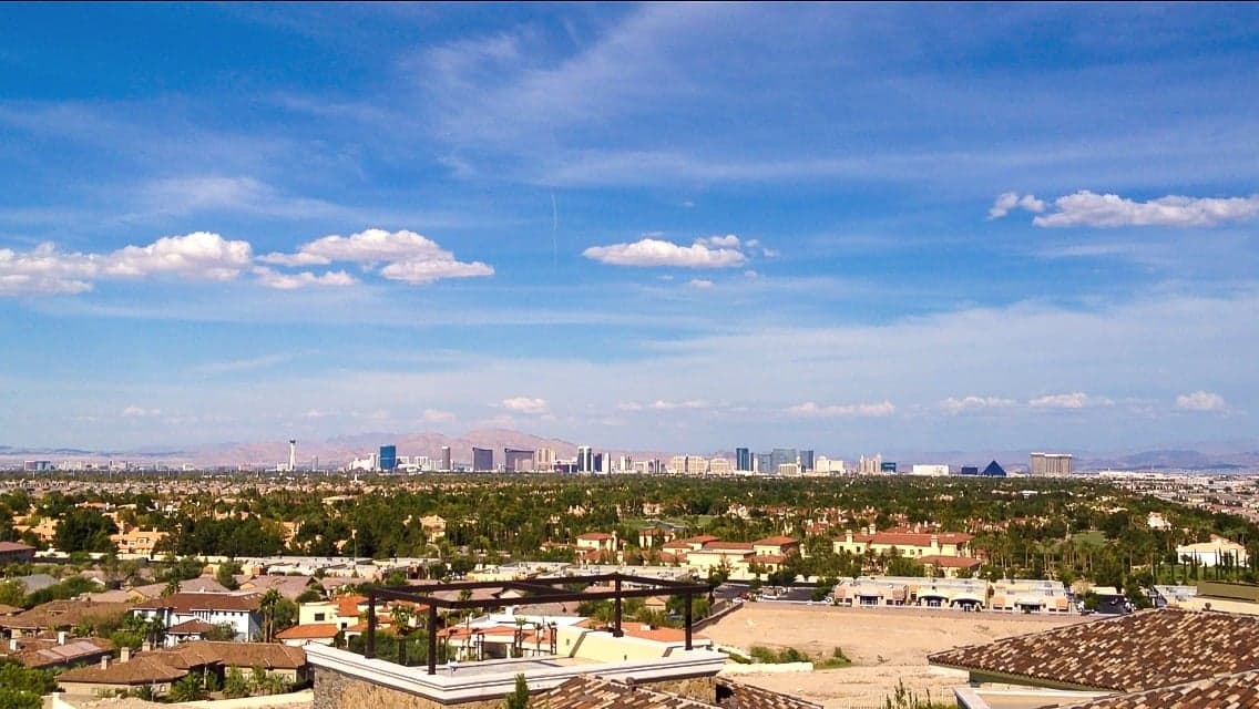
Spring Valley, Nevada, presents a mixed strategic picture for the conservative prepper or survivalist: it offers genuine resilience advantages in its desert climate and relative isolation from major coastal threats, but its proximity to the Las Vegas Strip and Nellis Air Force Base introduces significant vulnerabilities that cannot be ignored. Located in the Mojave Desert at roughly 2,500 feet elevation, the area benefits from low humidity, minimal seismic activity, and a climate that discourages the spread of many waterborne and vector-borne diseases. However, the same geography that provides natural defensibility also creates a harsh environment where water scarcity and extreme summer heat are constant, non-negotiable realities. For a relocator weighing long-term stability against immediate risks, Spring Valley demands a clear-eyed assessment of both its natural advantages and its exposure to man-made threats.
Geographic position and natural advantages for long-term survival
Spring Valley sits in the Las Vegas Valley, roughly 10 miles west of the Las Vegas Strip, but its position on the western edge of the metropolitan area offers a degree of separation from the densest population centers. The surrounding Spring Mountains provide a natural barrier to the west, with peaks reaching over 11,000 feet that create a rain shadow effect and limit access from that direction. The valley floor is flat and open, which aids in line-of-sight observation and potential defensive positioning, but also means there are few natural chokepoints for controlling movement. The area's elevation—around 2,500 to 3,000 feet—keeps temperatures slightly cooler than the lower desert, though summer highs still routinely exceed 105°F. The dry air and low annual rainfall (roughly 4 inches per year) mean that mold, rot, and many biological contaminants are less of a concern than in humid regions. The region sits on the Basin and Range geologic province, with low seismic risk compared to California, and no active volcanoes or significant floodplains within the immediate vicinity. For a prepper, the primary natural advantage is the desert's inherent defensibility: the lack of dense vegetation means clear sightlines, and the harsh climate itself acts as a filter for unprepared populations.
Risks, exposures, and proximity to fallout-relevant landmarks
The most significant strategic liability for Spring Valley is its proximity to the Las Vegas Strip and McCarran International Airport (now Harry Reid International Airport), both of which are high-value targets for any coordinated attack or civil unrest scenario. The Strip draws roughly 40 million visitors annually, creating a massive transient population that could become a source of chaos during a breakdown of order. Nellis Air Force Base, located about 15 miles northeast of Spring Valley, is a primary training center for the U.S. Air Force and home to the Thunderbirds demonstration squadron. In a major conflict, Nellis would be a high-priority target for enemy strikes, and its proximity means that any fallout or secondary effects from an attack on the base would directly threaten Spring Valley. The Nevada National Security Site (formerly the Nevada Test Site), located about 65 miles northwest, is another concern: while it is currently used for low-level experiments and training, its history of nuclear testing means the area has residual contamination risks, and any future incident there could affect downwind communities. The I-15 corridor, which runs through Las Vegas, is a major north-south artery that would become a funnel for refugees from California in a collapse scenario, potentially overwhelming local resources. For the survivalist, the key takeaway is that Spring Valley is not a remote bunker location—it is a suburban buffer zone that would see significant pressure from multiple directions during a crisis.
Practical resilience for a relocator: food, water, energy, and defensibility
Water is the single most critical vulnerability in Spring Valley. The area relies entirely on the Colorado River via Lake Mead, which has experienced historic low levels in recent years, dropping to roughly 30% of capacity in 2022 before recovering slightly. A prolonged drought or infrastructure failure would leave the entire Las Vegas Valley without a viable local water source. Rainwater harvesting is impractical due to low annual precipitation, and groundwater in the valley is brackish and limited. For a relocator, this means that any long-term survival plan must include either a deep well (if property allows) or a robust water storage and purification system capable of holding at least 30-60 days of supply. Food storage is more manageable: the dry climate is excellent for long-term food storage, and the area has several large warehouse-style stores (Costco, Sam's Club) within a 15-minute drive, though these would be quickly depleted in a crisis. Local agriculture is minimal, limited to small-scale desert farming operations, so food security would depend entirely on stored supplies or trade. Energy is a relative strength: the area averages over 300 days of sunshine per year, making solar power a highly viable option for off-grid electricity. Many homes in Spring Valley already have rooftop solar, and battery storage systems are becoming common. Natural gas is the primary heating fuel, and the grid is generally reliable, but a prolonged outage would leave residents without cooling in extreme heat—a life-threatening scenario. Defensibility is mixed: the suburban layout with cul-de-sacs and walled communities offers some natural perimeter control, but the flat terrain and grid-like street patterns mean that a determined group could approach from multiple directions. The best defensive strategy would be to establish a small, tight-knit neighborhood mutual aid group and harden a single home or compound with reinforced doors, window coverings, and a secure water source.
The overall strategic picture for Spring Valley is one of calculated trade-offs. It offers genuine advantages in climate, solar potential, and relative isolation from coastal population centers, but it is not a remote retreat—it is a suburban buffer zone that would face significant pressure from the Las Vegas metro area during any major crisis. For the conservative prepper who values a low-tax, low-regulation environment (Nevada has no state income tax and relatively lax gun laws) and is willing to invest heavily in water storage and solar infrastructure, Spring Valley can be a viable base of operations. However, it is not a location for those seeking complete self-sufficiency or guaranteed safety from man-made threats. The prudent relocator would treat Spring Valley as a staging area—a place to build resources and skills while maintaining a secondary bug-out location in the nearby Spring Mountains or rural Nye County. In a world of increasing uncertainty, Spring Valley offers a middle ground: better than most coastal suburbs, but far from the ideal survivalist haven.
* Values derived from national, state, county, city and local statistics and may differ in a specific area. Last updated: 2026-04-29T01:41:44.000Z
Narrative content on this page is AI-generated and may contain mistakes. Verify any details that matter before acting on them.
ReloMaps may earn a commission from affiliate links at no extra cost to you.