Photo: Wikipedia
Strategic Assessment of Grant County
Deep buffer from population centers and strategic targets. Low natural disaster risk and minimal exposure to border or coastal threats.
What does the Strategic Assessment tell us?
Our Strategic Assessment grades tactical survivability of an area. Major population centers, military targets, fallout zones, natural disasters, and border exposure all drive risk — lower exposure means a more defensible position in a crisis.
This is heavily inspired by Joel Skousen's Strategic Relocation book. Highly recommended you checkout the book ($)What does this tell us?
Our Strategic Assessment grades tactical survivability of an area. Major population centers, military targets, fallout zones, natural disasters, and border exposure all drive risk — lower exposure means a more defensible position in a crisis.
This is heavily inspired by Joel Skousen's Strategic Relocation book. Highly recommended you checkout the book ($)Strategic Pillars

Key Distances
Strategic Assessment Analysis
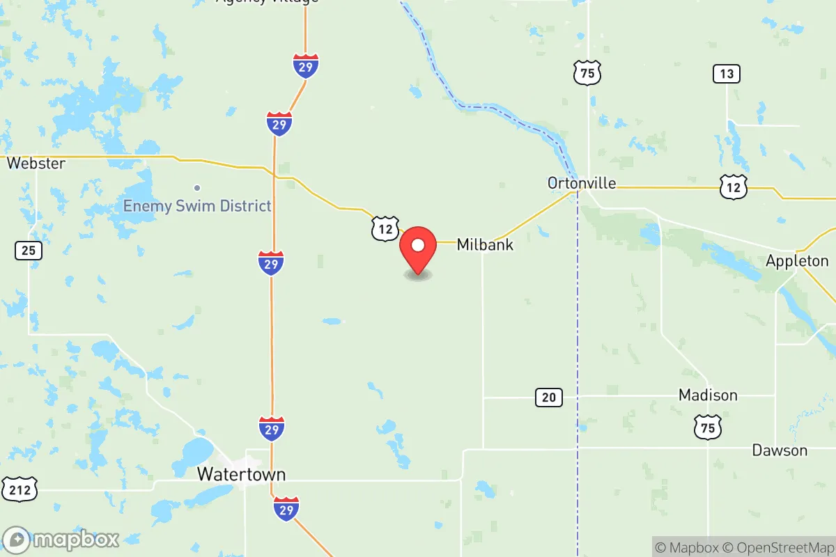
Grant County, South Dakota, offers a strategic relocation option for those prioritizing geographic insulation from major population centers and high-value target zones. Located in the northeastern corner of the state along the Minnesota border, this agricultural region sits well outside the blast radius and fallout patterns of any major metropolitan area, military installation, or industrial complex. For a relocator operating from a preparedness mindset, the county's low population density, strong agricultural base, and distance from known strategic targets create a baseline of resilience that is increasingly rare in the continental United States.
Why Grant County's geographic position offers natural strategic advantages
Grant County sits roughly 90 miles northeast of Sioux Falls and about 50 miles northwest of the Minneapolis-St. Paul metro area, placing it far enough from both to avoid direct blast effects or immediate fallout from a strike on either city. The county seat, Milbank, anchors a network of small communities including Big Stone City, Stockholm, and Twin Brooks, none of which exceed a few thousand residents. This dispersion of population across the county reduces the likelihood of cascading infrastructure failures that plague dense urban centers. The region sits on the Coteau des Prairies, a plateau that provides natural drainage and vantage points, and the county's eastern edge borders Big Stone Lake and the Minnesota River valley, offering both water resources and a natural barrier to movement from the east. The local topography is rolling prairie with scattered glacial lakes, which provides decent line-of-sight limitations and multiple natural choke points for anyone concerned with perimeter security. Winters are harsh, which itself acts as a deterrent to transient populations and limits the operational window for any large-scale movement through the area during much of the year.
Risks, exposures, and proximity to potential fallout-relevant landmarks
The primary strategic advantage of Grant County is what it lacks: there are no major military bases, no refineries, no nuclear power plants, no major ports, and no significant industrial targets within a 50-mile radius. The nearest facility of any strategic concern is the Monticello Nuclear Generating Plant in Minnesota, roughly 120 miles east-northeast, which is far enough that prevailing westerly winds would carry any fallout away from Grant County in most scenarios. The Ellsworth Air Force Base near Rapid City is over 300 miles west, and the Minot Air Force Base in North Dakota is about 250 miles northwest — both are primary strategic targets, but their distance and the intervening geography make direct fallout contamination unlikely. The nearest rail and highway corridors that could see secondary targeting are the I-29 corridor west of the county and the I-94 corridor to the north, but neither passes through Grant County itself. The real risk here is not a direct strike but the possibility of secondary migration: if a major event occurs in the Twin Cities or Sioux Falls, Grant County sits along potential evacuation routes. County roads and state highways like SD-15 and SD-20 offer multiple egress options but also potential ingress for displaced populations. The county's agricultural economy means that fuel and fertilizer storage facilities exist, but these are small-scale and not likely to be primary targets. For the prepared relocator, the absence of high-value infrastructure within the county is a net positive, but the proximity to potential refugee flow corridors requires advance planning for perimeter security and resource denial.
Practical resilience for a relocator: food, water, energy, and defensibility
Grant County's agricultural base is its strongest asset for long-term resilience. The county produces corn, soybeans, wheat, and hay, along with significant livestock operations in cattle and hogs. Milbank is home to a major dairy processing facility and a large turkey processing plant, meaning that even in a disrupted supply chain, local food production remains operational. Water resources are abundant: Big Stone Lake provides a substantial surface water source on the eastern border, and the county sits atop the Quaternary aquifer system, which means well water is accessible across most of the area. For energy, the county is served by rural electric cooperatives, and the dispersed nature of the population means that grid failure would affect fewer people per square mile than in suburban or urban settings. Wooded areas along the Minnesota River and around the glacial lakes provide fuel for heating, though the harsh winters mean that any relocator needs to have a serious plan for winterization and fuel storage. Defensibility is moderate: the open prairie offers long sightlines but limited cover, which cuts both ways. The small towns are tight-knit, and newcomers who integrate well will find that community cohesion is a force multiplier for security. The county sheriff's office in Milbank maintains a visible presence, and the local culture leans heavily toward self-reliance, firearm ownership, and mutual aid — all factors that align with a preparedness mindset. For a single individual or a family, the ability to establish a household with a garden, livestock, and a well is realistic here, and the cost of land remains well below national averages.
The overall strategic picture for Grant County is one of quiet viability. It is not a hardened bunker location, nor does it offer the kind of extreme isolation found in the mountain west or the high plains. What it does offer is a realistic, sustainable option for someone who wants to be out of range of the primary threat vectors while still having access to the infrastructure and community support needed to thrive in a degraded scenario. The winters are a genuine hardship, but they also provide a seasonal buffer against the kind of population movement that would overwhelm less remote areas. For the relocator who values agricultural self-sufficiency, water security, and a community that does not need to be convinced that preparedness is prudent, Grant County deserves a hard look. It is not flashy, but it is solid — and in the world we are preparing for, solid is worth more than flashy every time.
* Values derived from national, state, county, city and local statistics and may differ in a specific area. Last updated: 2026-05-15T02:08:48.000Z
Narrative content on this page is AI-generated and may contain mistakes. Verify any details that matter before acting on them.
ReloMaps may earn a commission from affiliate links at no extra cost to you.