
Photo: Wikipedia
Strategic Assessment of Ranson, WV
Meaningful friction. Expect exposure to either population pressure, blast zones, or natural disaster risk. Consider buying a retreat property.
What does the Strategic Assessment tell us?
Our Strategic Assessment grades tactical survivability of an area. Major population centers, military targets, fallout zones, natural disasters, and border exposure all drive risk — lower exposure means a more defensible position in a crisis.
This is heavily inspired by Joel Skousen's Strategic Relocation book. Highly recommended you checkout the book ($)What does this tell us?
Our Strategic Assessment grades tactical survivability of an area. Major population centers, military targets, fallout zones, natural disasters, and border exposure all drive risk — lower exposure means a more defensible position in a crisis.
This is heavily inspired by Joel Skousen's Strategic Relocation book. Highly recommended you checkout the book ($)Strategic Pillars

Key Distances
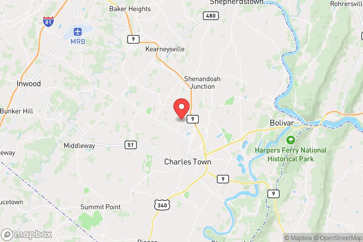
Regional Safe Places
Below is our recommended "safe zones" in West Virginia and the surrounding area based on our strategic heuristics. For most people, it's unrealistic to live in a “safe zone” full-time due to work, family or other personal reasons. They tend to be more rural. However, many of these areas are perfect for second homes and retreat properties that double as a vacation home or even a short-term rental.


Important Note: For informational purposes only. This does not mean nothing bad ever happens in the green zones. Please use common sense. This is based on public data and modeled with AI. We tried to take a conservative approach but mistakes happen. We update this regularly as new information becomes available.
Solar Generator Recommendations
Backup power matters more here than in safer locations. We've picked three solar generators across budgets and capacity tiers — start with the budget unit if you only need a few essentials, or step up if you want to run a fridge and HVAC for days at a time.

Jackery Portable Power Station Explorer 300
Budget OptionPower on the Go: Weighing only 11 lbs, it's convenient to set up and store with book-sized foldable solar panels

BLUETTI Portable Power Station AC180
Designed for both indoor and outdoor scenarios, AC180 is highly capable as it has a robost capacity and continuous output power.

EF ECOFLOW DELTA Pro Ultra Power Station
Upgraded PickEcoFlow DELTA Pro Ultra is a whole-home energy system designed to grow with your family. Integrated with the Smart Home Panel 2, it scales to meet your evolving energy needs — keeping your home powered, intelligent, and secure through every stage of life.
We earn a commission, at no additional cost to you.
Strategic Assessment Analysis
Ranson, West Virginia, offers a surprisingly resilient strategic position for those prioritizing preparedness, combining the protective buffer of the Blue Ridge Mountains with practical access to critical infrastructure. This small Jefferson County town sits just 70 miles from Washington, D.C., yet feels worlds apart in terms of density and vulnerability, making it a viable fallback location for individuals and families who want to stay within a few hours of the Eastern Seaboard without being in the blast zone. The area’s historical isolation, modest population, and local resource base provide a foundation for self-reliance that many more suburbanized parts of the Mid-Atlantic simply cannot match.
Geographic position and natural defensive advantages
Ranson’s location in the eastern panhandle of West Virginia places it in a natural corridor between the Shenandoah Valley and the Potomac River, but the surrounding terrain offers genuine defensive value. The town sits at the base of the Blue Ridge Mountains, with the Appalachian Trail running just to the west, creating a natural barrier that slows movement from the D.C. metro area. Elevation here averages around 500 feet, which is low enough to avoid extreme winter isolation but high enough to provide good line-of-sight and drainage—critical for both security and flood avoidance. The nearby Shenandoah National Park and George Washington National Forest to the east and south form a vast, sparsely populated buffer zone, meaning any large-scale unrest or evacuation from the D.C. region would have to funnel through a limited number of mountain passes and river crossings. This chokepoint geography is a double-edged sword: it protects Ranson from being overrun quickly, but it also means that if those passes are blocked or contested, resupply and egress become difficult. For a relocator, the key takeaway is that Ranson is not a primary target—it’s too small and too far from the core of federal power to warrant a direct strike or occupation—but it sits close enough to monitor events in the capital and potentially serve as a staging area for those who need to move deeper into the mountains.
Risks, exposures, and proximity to fallout-relevant landmarks
The most significant risk for Ranson is its proximity to the Washington, D.C. metropolitan area, which is a top-tier target for any adversary considering a nuclear or electromagnetic pulse (EMP) attack. At 70 miles, Ranson is outside the likely blast radius for a ground burst on the National Mall, but it falls within the moderate fallout zone for a high-yield airburst or a surface burst targeting nearby military installations. The town is roughly 40 miles from Fort Detrick in Frederick, Maryland, a major biodefense and research facility that could be a secondary target, and about 50 miles from the Raven Rock Mountain Complex, the alternate Pentagon command center. These are not trivial distances—fallout patterns depend heavily on wind direction, and prevailing winds in this region blow from the west, which would carry contamination away from Ranson in many scenarios. However, a shift to easterly winds could put the town in a dangerous plume path. The more immediate risk is civil unrest: Ranson’s location on the commuter rail line (MARC) and its proximity to I-81 and I-70 mean that a collapse of order in D.C. could send waves of refugees and looters through the area within hours. The town’s population of roughly 5,500 is too small to absorb a large influx without strain, and local law enforcement resources are limited. For a prepper, this means that Ranson is a good secondary location—a place to have a stocked retreat that you can reach before the masses—but not a primary bug-out destination if you’re starting from inside the Beltway.
Practical resilience for a relocator: food, water, energy, and defensibility
On the practical side, Ranson has several underappreciated advantages for long-term self-sufficiency. The town sits in the Potomac River watershed, with the Shenandoah River about 10 miles to the south and the Potomac itself about 15 miles to the north. Groundwater is generally accessible via shallow wells in the valley, though the underlying karst limestone geology means water quality can vary and requires filtration. The local climate supports a 180-day growing season, which is long enough for most staple crops like corn, beans, and squash, and the surrounding farmland is some of the most productive in West Virginia. Jefferson County has a strong agricultural heritage, with dozens of working farms within a 20-minute drive, meaning that in a prolonged crisis, barter networks for fresh food would be more viable here than in most suburban areas. Energy resilience is a mixed bag: the local grid is served by Potomac Edison, which has a history of storm-related outages, but the area’s moderate tree cover and lower population density mean that solar panels are a practical investment, and wood heat is a realistic backup option given the nearby forests. Defensibility at the property level is good—Ranson’s residential lots tend to be larger than in typical subdivisions, and the town’s layout includes several dead-end roads and cul-de-sacs that can be monitored or blocked. The biggest weakness is the lack of a strong local manufacturing base for critical supplies like ammunition, medical gear, or replacement parts; you would need to stockpile these in advance or rely on trips to larger towns like Charles Town (5 miles west) or Martinsburg (15 miles north). For a family, the school system is adequate but not exceptional, and the community is small enough that you can build relationships with neighbors quickly—a factor that matters more for mutual aid than any physical barrier.
The overall strategic picture for Ranson is one of cautious optimism for the prepared relocator. It is not a fortress, nor is it a remote wilderness retreat—it is a working-class town with a solid geographic buffer, decent natural resources, and a manageable risk profile for someone who wants to be within striking distance of the East Coast without living in a target zone. The proximity to D.C. is both the biggest liability and the biggest asset: it means you can monitor the situation and act early, but it also means you cannot afford to be complacent about evacuation timelines or supply stockpiles. For a conservative-minded individual or family who accepts that the world is trending toward instability, Ranson offers a realistic middle ground—close enough to matter, far enough to survive.
* Values derived from national, state, county, city and local statistics and may differ in a specific area. Last updated: 2026-04-23T06:07:43.000Z
Narrative content on this page is AI-generated and may contain mistakes. Verify any details that matter before acting on them.
ReloMaps may earn a commission from affiliate links at no extra cost to you.