
Photo: Wikipedia
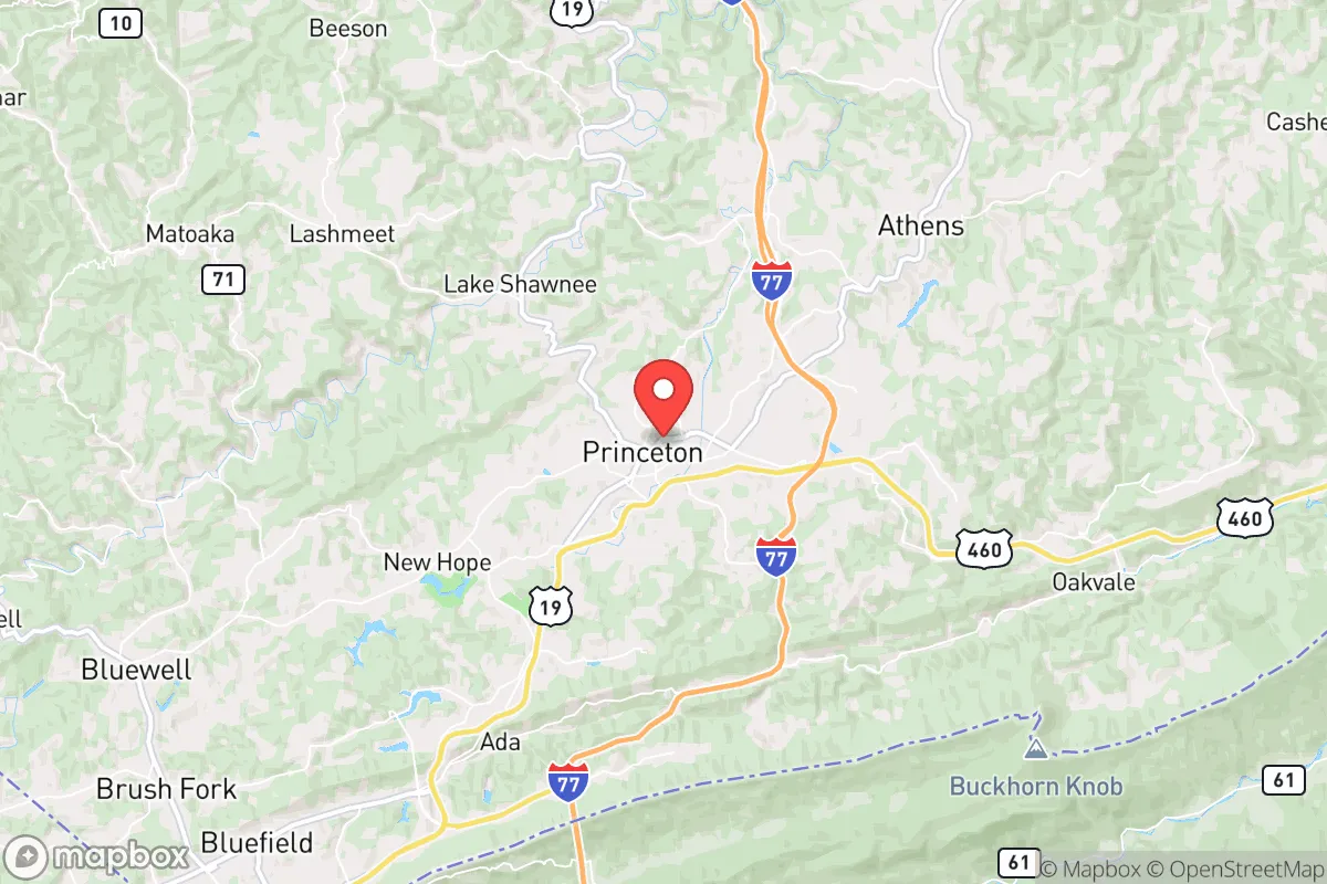
Strategic Assessment of Princeton, WV
Meaningful friction. Expect exposure to either population pressure, blast zones, or natural disaster risk. Consider buying a retreat property.
What does the Strategic Assessment tell us?
Our Strategic Assessment grades tactical survivability of an area. Major population centers, military targets, fallout zones, natural disasters, and border exposure all drive risk — lower exposure means a more defensible position in a crisis.
This is heavily inspired by Joel Skousen's Strategic Relocation book. Highly recommended you checkout the book ($)What does this tell us?
Our Strategic Assessment grades tactical survivability of an area. Major population centers, military targets, fallout zones, natural disasters, and border exposure all drive risk — lower exposure means a more defensible position in a crisis.
This is heavily inspired by Joel Skousen's Strategic Relocation book. Highly recommended you checkout the book ($)Strategic Pillars

Key Distances
Regional Safe Places
Below is our recommended "safe zones" in West Virginia and the surrounding area based on our strategic heuristics. For most people, it's unrealistic to live in a “safe zone” full-time due to work, family or other personal reasons. They tend to be more rural. However, many of these areas are perfect for second homes and retreat properties that double as a vacation home or even a short-term rental.


Important Note: For informational purposes only. This does not mean nothing bad ever happens in the green zones. Please use common sense. This is based on public data and modeled with AI. We tried to take a conservative approach but mistakes happen. We update this regularly as new information becomes available.
Solar Generator Recommendations
Backup power matters more here than in safer locations. We've picked three solar generators across budgets and capacity tiers — start with the budget unit if you only need a few essentials, or step up if you want to run a fridge and HVAC for days at a time.

Jackery Portable Power Station Explorer 300
Budget OptionPower on the Go: Weighing only 11 lbs, it's convenient to set up and store with book-sized foldable solar panels

BLUETTI Portable Power Station AC180
Designed for both indoor and outdoor scenarios, AC180 is highly capable as it has a robost capacity and continuous output power.

EF ECOFLOW DELTA Pro Ultra Power Station
Upgraded PickEcoFlow DELTA Pro Ultra is a whole-home energy system designed to grow with your family. Integrated with the Smart Home Panel 2, it scales to meet your evolving energy needs — keeping your home powered, intelligent, and secure through every stage of life.
We earn a commission, at no additional cost to you.
Strategic Assessment Analysis
Princeton, West Virginia, offers a strategic relocation option for those prioritizing resilience, offering a blend of geographic isolation and practical self-sufficiency that is increasingly rare in the modern United States. Situated in Mercer County, near the southern tip of the state, this small city of roughly 6,000 people sits at a crossroads of two major interstates—I-77 and I-460—providing a critical advantage: access to regional resources without being a primary target. For the prepper or survivalist, Princeton represents a calculated bet on a location that is far enough from major population centers to avoid the worst of civil unrest, yet connected enough to allow for supply runs or evacuation if necessary. The area’s history as a coal and railroad hub has ingrained a culture of hardiness and self-reliance, traits that align well with a conservative mindset focused on preparedness and community stability.
Geographic position and natural advantages for long-term security
Princeton’s location in the Appalachian Plateau provides a natural defensive buffer that is hard to overstate. The surrounding mountains, dense forests, and winding hollows create a terrain that is inherently difficult for large-scale movement, whether that be by unruly crowds or government forces. The city itself sits at an elevation of roughly 2,400 feet, which offers a cooler climate and reduces the risk of flooding compared to low-lying areas along the Ohio River. This high ground also provides a vantage point for monitoring the two main arteries: I-77, which runs north-south from Charleston to the North Carolina border, and I-460, which connects to Roanoke, Virginia, about 90 miles east. For a relocator, this means you can observe traffic patterns and potential threats from a distance, while the rugged terrain limits the number of viable approach routes. The nearby Bluestone River and Bluestone Lake, part of the Bluestone National Scenic River, offer a reliable water source and a natural barrier to the east. The area’s karst topography—limestone caves and springs—also provides opportunities for off-grid water collection and storage, a key asset for long-term sustainability. In a worst-case scenario, the mountains act as a natural filter, slowing down any cascading chaos from the East Coast corridor, which is only a few hours away.
Risks, exposures, and proximity to fallout-relevant landmarks
No location is without its vulnerabilities, and Princeton has several that a serious prepper must weigh. The most immediate concern is its proximity to the I-77 corridor, which is a major north-south route for both commerce and military logistics. In a crisis, this highway could become a chokepoint for refugees fleeing the Washington D.C. metro area—about 300 miles northeast—or from Charlotte, roughly 200 miles south. While 300 miles seems distant, a mass evacuation event could push waves of people into the region within days, especially if the interstate system remains operational. Additionally, Princeton is within 100 miles of the Blue Ridge Mountains and the Shenandoah Valley, areas that could see significant military or FEMA activity during a national emergency. The city’s own infrastructure is a double-edged sword: the Princeton-Interstate 77 Industrial Park and the nearby Mercer County Airport (a general aviation field) could become targets for looting or government requisition. More critically, the region is within 150 miles of the Oak Ridge National Laboratory in Tennessee, a major nuclear research facility that could be a primary target in a conflict. While Princeton itself is not in a direct fallout zone from Oak Ridge, prevailing winds from the west could carry radioactive particles into the area, depending on the season. The presence of coal-fired power plants in the region, such as the John E. Amos Plant near Charleston, also poses a secondary risk: these facilities could be targeted for sabotage or become sources of toxic ash dispersion. For the survivalist, the key takeaway is that Princeton is not a remote bunker—it’s a strategic outpost that requires active monitoring of both natural and man-made threats.
Practical resilience for a relocator: food, water, energy, and defensibility
When it comes to daily survival logistics, Princeton offers a surprisingly robust foundation. The area’s agricultural heritage means that local food production is viable, with small farms and livestock operations scattered throughout Mercer County. The Mercer County Farmers Market, held in downtown Princeton, is a year-round source of fresh produce, meats, and preserves, and building relationships with local growers is a straightforward way to secure a food supply outside the grocery store system. For water, the Bluestone River and its tributaries provide a year-round surface source, but the real advantage is the region’s groundwater. Many properties in the surrounding hollows have private wells, and the limestone bedrock allows for easy drilling of new wells if needed. Rainwater collection is also practical, given the area’s average annual rainfall of about 40 inches. Energy is a mixed bag: the local grid is served by Appalachian Power, a subsidiary of American Electric Power, which has a history of outages during winter storms. However, the prevalence of coal and natural gas in the region means that propane and heating oil are readily available, and many homes already have wood-burning stoves as a backup. Solar potential is moderate due to the mountainous terrain and frequent cloud cover, but a well-placed array on a south-facing slope can still generate enough power for a basic off-grid setup. Defensibility is where Princeton truly shines. The city’s layout, with its historic downtown nestled in a valley and residential areas climbing the hillsides, allows for natural observation points. The surrounding national forests—Jefferson National Forest to the east and the George Washington National Forest further north—offer vast areas for retreat or caching supplies. For a single individual or a family, the ability to secure a property on a dead-end hollow road, with a clear view of the only approach, is a realistic option here. The local culture of hunting, fishing, and firearms ownership is strong, meaning you won’t stand out as an outsider for being prepared. The Mercer County Sheriff’s Office and the Princeton Police Department are professional but understaffed, so self-reliance is expected, not judged.
In the overall strategic picture, Princeton, WV, is a calculated compromise between isolation and accessibility. It is not a remote wilderness retreat—you will have neighbors, and you will be within a few hours of major population centers that could become sources of unrest. But for the conservative-minded relocator who wants to be prepared for civic breakdown, mass casualty events, or natural disasters, this area offers a rare combination of natural defenses, resource availability, and a community that values self-sufficiency. The key is to treat Princeton as a base of operations, not a final redoubt. Establish your property, build local relationships, and keep a low profile. Monitor the I-77 corridor and the Oak Ridge situation, and have a secondary retreat plan deeper into the Monongahela National Forest if needed. The mountains here will not save you from every threat, but they will give you the time and space to make the right decisions when others are panicking. That is the real value of this location: it buys you options.
* Values derived from national, state, county, city and local statistics and may differ in a specific area. Last updated: 2026-05-01T10:12:43.000Z
Narrative content on this page is AI-generated and may contain mistakes. Verify any details that matter before acting on them.
ReloMaps may earn a commission from affiliate links at no extra cost to you.