
Photo: Wikipedia
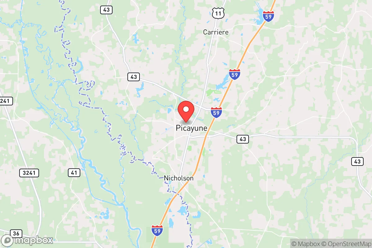
Strategic Assessment of Picayune, MS
Workable tactical position. Some exposure to population density or targets, but generally defensible in a crisis.
What does the Strategic Assessment tell us?
Our Strategic Assessment grades tactical survivability of an area. Major population centers, military targets, fallout zones, natural disasters, and border exposure all drive risk — lower exposure means a more defensible position in a crisis.
This is heavily inspired by Joel Skousen's Strategic Relocation book. Highly recommended you checkout the book ($)What does this tell us?
Our Strategic Assessment grades tactical survivability of an area. Major population centers, military targets, fallout zones, natural disasters, and border exposure all drive risk — lower exposure means a more defensible position in a crisis.
This is heavily inspired by Joel Skousen's Strategic Relocation book. Highly recommended you checkout the book ($)Strategic Pillars

Key Distances
Regional Safe Places
Below is our recommended "safe zones" in Mississippi and the surrounding area based on our strategic heuristics. For most people, it's unrealistic to live in a “safe zone” full-time due to work, family or other personal reasons. They tend to be more rural. However, many of these areas are perfect for second homes and retreat properties that double as a vacation home or even a short-term rental.
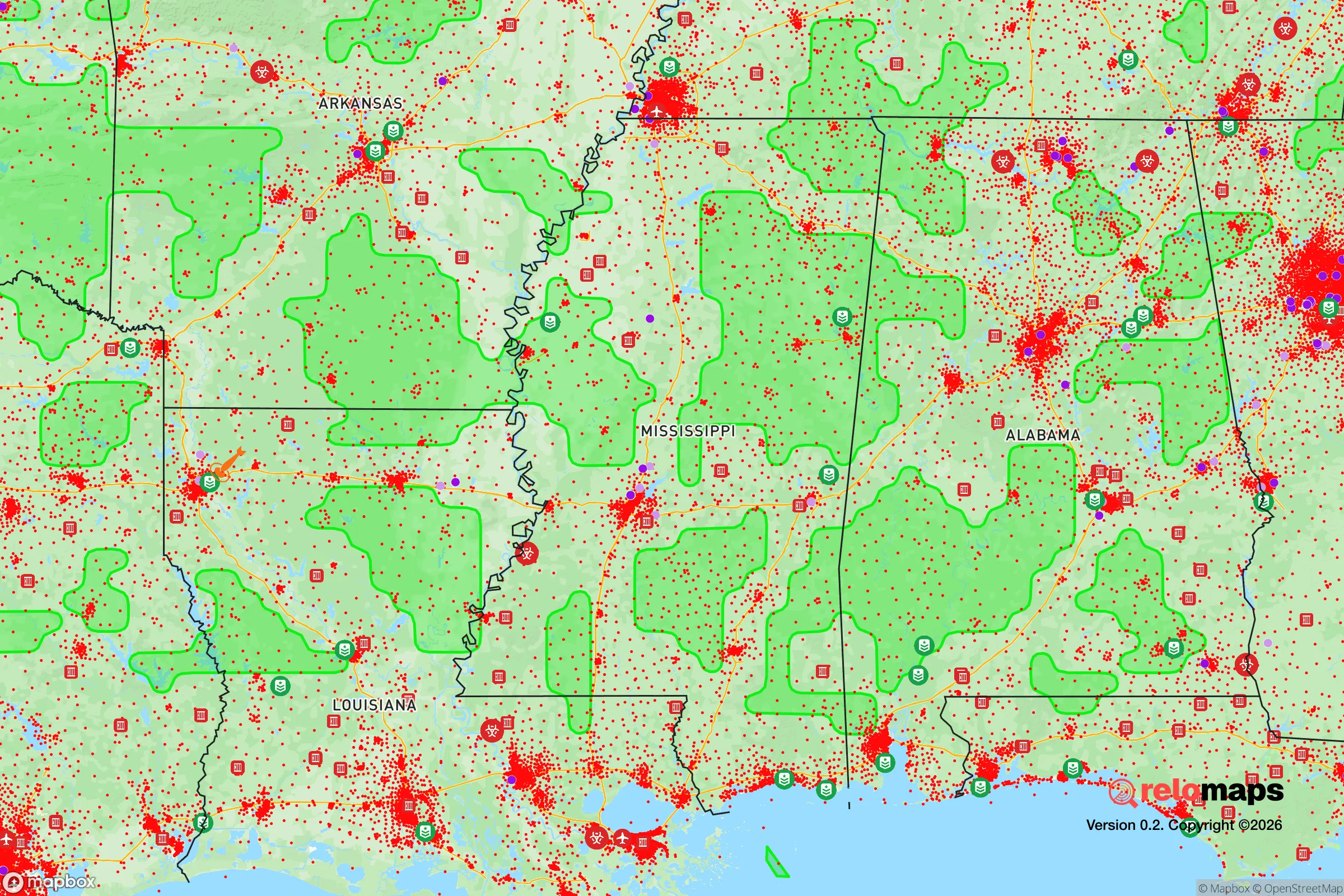
Important Note: For informational purposes only. This does not mean nothing bad ever happens in the green zones. Please use common sense. This is based on public data and modeled with AI. We tried to take a conservative approach but mistakes happen. We update this regularly as new information becomes available.
Solar Generator Recommendations
Backup power matters more here than in safer locations. We've picked three solar generators across budgets and capacity tiers — start with the budget unit if you only need a few essentials, or step up if you want to run a fridge and HVAC for days at a time.

Jackery Portable Power Station Explorer 300
Budget OptionPower on the Go: Weighing only 11 lbs, it's convenient to set up and store with book-sized foldable solar panels

BLUETTI Portable Power Station AC180
Designed for both indoor and outdoor scenarios, AC180 is highly capable as it has a robost capacity and continuous output power.

EF ECOFLOW DELTA Pro Ultra Power Station
Upgraded PickEcoFlow DELTA Pro Ultra is a whole-home energy system designed to grow with your family. Integrated with the Smart Home Panel 2, it scales to meet your evolving energy needs — keeping your home powered, intelligent, and secure through every stage of life.
We earn a commission, at no additional cost to you.
Strategic Assessment Analysis
Picayune, Mississippi, sits in a sweet spot that few relocation analysts talk about openly: close enough to the Gulf Coast to matter, far enough from New Orleans and the Mississippi coast’s population centers to avoid the worst of any urban collapse or fallout plume. This town of roughly 11,000 people, anchored along Interstate 59 about 45 miles northeast of New Orleans and 30 miles northwest of Gulfport, offers a strategic buffer zone that preppers and survival-minded families should take seriously. The area’s resilience comes from its position on higher ground relative to the coast, its access to multiple evacuation routes, and its location in a state that consistently ranks among the most firearm-friendly and low-regulation in the country. For someone looking to plant roots in a place that can weather both natural disasters and civil unrest, Picayune deserves a hard look.
Geographic position and natural advantages for long-term survival
Picayune’s geography is its primary strategic asset. The city sits on the Pearl River basin, with the Pearl River itself forming the western boundary of Pearl River County. This river system provides a natural water source that is less likely to be contaminated by coastal storm surge or industrial runoff compared to areas closer to the Gulf. The surrounding terrain is piney woods and low hills—nothing dramatic, but enough to offer cover and defensible positions if things go sideways. The area is part of the longleaf pine ecosystem, which means timber, wildlife, and natural resources are abundant. Deer, turkey, and small game are present in the surrounding national forests, including the nearby De Soto National Forest to the east, which offers over 500,000 acres of public land for hunting, foraging, and retreat if needed. The climate is humid subtropical, with mild winters and long growing seasons—ideal for year-round gardening and livestock. The average first frost date is mid-November, and the last frost is typically mid-March, giving a solid 8-month growing window. Rainfall averages about 60 inches annually, so water catchment is viable without extreme measures. For a relocator thinking about food security and water independence, Picayune’s natural endowment is better than most places in the Deep South that aren’t already overrun by development.
Risks, exposures, and proximity to fallout-relevant landmarks
No analysis is honest without addressing the downsides. Picayune’s biggest exposure is its proximity to New Orleans, a major port city with a petrochemical corridor stretching from Baton Rouge to the Gulf. If a major economic collapse, disease outbreak, or coordinated attack targets the Mississippi River industrial corridor, the fallout—literal or figurative—could push north along I-59 and I-10. The city is also within 30 miles of the Stennis Space Center, a NASA and Navy research facility that could be a secondary target in a conflict scenario. Additionally, the area is prone to hurricanes. Hurricane Katrina in 2005 devastated parts of Pearl River County, with storm surge pushing up the Pearl River and flooding low-lying areas. Picayune itself sits at about 70 feet above sea level, which mitigates storm surge risk, but wind damage and prolonged power outages are real threats. The local power grid is served by Mississippi Power and Coast Electric, both of which have improved hardening since Katrina, but a direct hit from a Category 3 or higher would still knock out power for weeks. For the prepper mindset, these risks mean you need to plan for self-sufficiency in the immediate aftermath of a storm, not just a societal collapse. The good news is that the area’s low population density—about 60 people per square mile in the county—means fewer desperate neighbors competing for resources after a disaster.
Practical resilience for a relocator: food, water, energy, and defensibility
For a single individual or family moving to Picayune with a prepper mindset, the practicalities of daily life are favorable. Water is the first concern: the Pearl River is a reliable surface water source, but it requires treatment. The city’s municipal water comes from groundwater wells, which are less vulnerable to contamination than surface water intakes. For off-grid setups, shallow wells in the area typically hit water at 30-50 feet, and the water table is high enough that hand pumps are feasible. Rainwater catchment is also straightforward given the annual rainfall. Food production is viable: the soil in Pearl River County is sandy loam, which drains well but requires amendment for heavy vegetable production. Raised beds or hugelkultur mounds work well. Local ordinances are minimal—there are no county-level restrictions on backyard chickens, goats, or even pigs, though city limits may have some nuisance laws. The county is a right-to-farm area, meaning agricultural activities are protected from nuisance lawsuits. Energy resilience is a mixed bag. The area gets plenty of sun for solar panels—about 215 sunny days per year—but hurricanes mean you need a system that can be quickly disconnected and stored. Propane is widely available, and many rural properties already have propane tanks for heating and cooking. Defensibility is where Picayune shines. The town is laid out along a few main roads, with rural subdivisions and acreage properties offering natural chokepoints. The local law enforcement presence is modest—Pearl River County Sheriff’s Office has about 40 deputies for the entire county—so in a prolonged crisis, you’re largely on your own. That’s a feature, not a bug, for those who prefer to rely on their own capabilities. The local gun culture is strong, with multiple gun shops and ranges in the area, and Mississippi is a constitutional carry state with no permit required for concealed or open carry. Property crime rates are moderate—about 25 per 1,000 residents annually—but violent crime is low compared to the national average. The biggest practical concern for a relocator is medical access. The nearest Level 1 trauma center is in New Orleans, 45 minutes away. For serious emergencies, you’re looking at a long drive or a helicopter ride. Stockpiling medical supplies and learning basic trauma care is non-negotiable.
The overall strategic picture for Picayune is one of calculated trade-offs. It’s not a remote mountain redoubt, and it’s not a fortified compound in the middle of nowhere. What it offers is a middle ground: a low-cost, low-regulation environment with enough natural resources to sustain a family through a multi-year disruption, while still being within a few hours of major medical and supply hubs if things stabilize. The conservative political climate—Pearl River County voted 78% for Trump in 2020—means local governance is unlikely to impose lockdowns, vaccine mandates, or other restrictions that drove many relocators out of blue states. The biggest risk is complacency. Hurricanes will test your preparations every few years, and the proximity to New Orleans means you need a plan for evacuation or shelter-in-place depending on the threat. But for someone who wants to be ready for the worst while still living a normal life in a community that shares their values, Picayune is a solid bet. It’s not flashy, and it won’t make the cover of survivalist magazines. It’s just a place where the math works.
* Values derived from national, state, county, city and local statistics and may differ in a specific area. Last updated: 2026-04-19T05:36:22.000Z
Narrative content on this page is AI-generated and may contain mistakes. Verify any details that matter before acting on them.
ReloMaps may earn a commission from affiliate links at no extra cost to you.