
Photo: Wikipedia
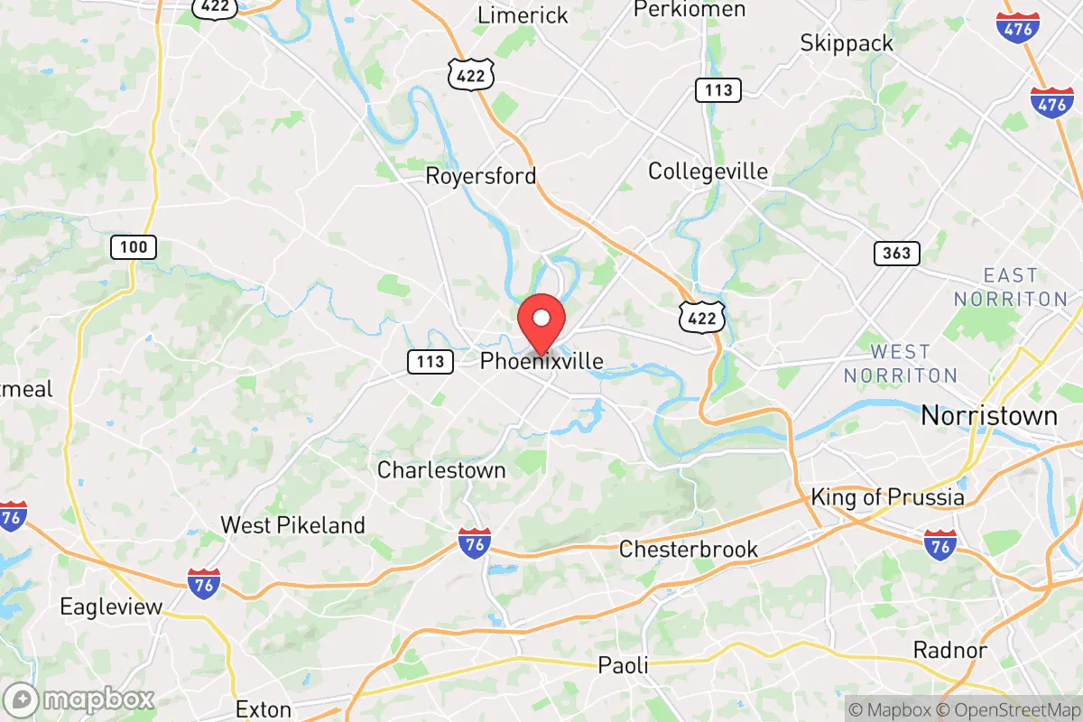
Strategic Assessment of Phoenixville, PA
Multiple tactical vulnerabilities. Population density, target proximity, or disaster risk are likely compounding. A retreat property and exit planning is required.
What does the Strategic Assessment tell us?
Our Strategic Assessment grades tactical survivability of an area. Major population centers, military targets, fallout zones, natural disasters, and border exposure all drive risk — lower exposure means a more defensible position in a crisis.
This is heavily inspired by Joel Skousen's Strategic Relocation book. Highly recommended you checkout the book ($)What does this tell us?
Our Strategic Assessment grades tactical survivability of an area. Major population centers, military targets, fallout zones, natural disasters, and border exposure all drive risk — lower exposure means a more defensible position in a crisis.
This is heavily inspired by Joel Skousen's Strategic Relocation book. Highly recommended you checkout the book ($)Strategic Pillars

Key Distances
Regional Safe Places
Below is our recommended "safe zones" in Pennsylvania and the surrounding area based on our strategic heuristics. For most people, it's unrealistic to live in a “safe zone” full-time due to work, family or other personal reasons. They tend to be more rural. However, many of these areas are perfect for second homes and retreat properties that double as a vacation home or even a short-term rental.


Important Note: For informational purposes only. This does not mean nothing bad ever happens in the green zones. Please use common sense. This is based on public data and modeled with AI. We tried to take a conservative approach but mistakes happen. We update this regularly as new information becomes available.
Solar Generator Recommendations
Backup power matters more here than in safer locations. We've picked three solar generators across budgets and capacity tiers — start with the budget unit if you only need a few essentials, or step up if you want to run a fridge and HVAC for days at a time.

Jackery Portable Power Station Explorer 300
Budget OptionPower on the Go: Weighing only 11 lbs, it's convenient to set up and store with book-sized foldable solar panels

BLUETTI Portable Power Station AC180
Designed for both indoor and outdoor scenarios, AC180 is highly capable as it has a robost capacity and continuous output power.

EF ECOFLOW DELTA Pro Ultra Power Station
Upgraded PickEcoFlow DELTA Pro Ultra is a whole-home energy system designed to grow with your family. Integrated with the Smart Home Panel 2, it scales to meet your evolving energy needs — keeping your home powered, intelligent, and secure through every stage of life.
We earn a commission, at no additional cost to you.
Strategic Assessment Analysis
Phoenixville, Pennsylvania, presents a mixed bag for the strategic relocator. Its location offers genuine resilience advantages—proximity to the Schuylkill River and the natural buffer of the Valley Forge National Historical Park—but its position within the densely populated Philadelphia–Reading corridor introduces significant vulnerabilities. For a conservative-leaning individual or family prioritizing self-reliance and preparedness, Phoenixville is not a survivalist stronghold, but a calculated compromise: a semi-urban hub with decent access to resources, yet uncomfortably close to major population centers and potential fallout targets.
Geographic position and natural advantages for long-term security
Phoenixville sits at the confluence of the Schuylkill River and French Creek, which provides both a reliable water source and a natural barrier to movement. The surrounding landscape is a mix of rolling hills, woodlands, and preserved open space, notably the 3,500-acre Valley Forge National Historical Park to the east and the 7,700-acre French Creek State Park to the west. This green belt offers limited but real defensible terrain—dense forest and steep ravines that could slow foot traffic or vehicle movement in a crisis. The area's elevation, roughly 100–200 feet above the river valley, gives modest vantage points for observation. However, the terrain is not mountainous; it's gentle enough that a determined group could traverse it without much difficulty. The Schuylkill River itself is a double-edged sword: it provides a potential water source for filtration and small-scale hydropower, but its floodplain is prone to inundation during heavy rains, and the river is a known transportation corridor for both people and goods, meaning it could become a chokepoint or a route for unwanted traffic.
Risks, exposures, and proximity to fallout-relevant landmarks
The most glaring risk is Phoenixville's proximity to Philadelphia, just 28 miles southeast, and the Philadelphia International Airport, a likely target for any major disruption. The area also lies within 15 miles of the Limerick Generating Station, a nuclear power plant on the Schuylkill River. While the plant has a solid safety record, a catastrophic failure or a deliberate attack would place Phoenixville directly in the potential plume path, depending on wind direction. Additionally, the borough is near the Reading–Philadelphia rail corridor, a high-value infrastructure target. The presence of the U.S. Army's Fort Indiantown Gap, about 60 miles northwest, is a mixed signal: it could be a source of military support or a magnet for federal attention. For the prepper, the key takeaway is that Phoenixville is not a remote retreat; it's a suburban node within a larger grid that could become a target or a chokepoint. The borough's population density of roughly 4,500 people per square mile means that any mass evacuation would be chaotic, with limited egress routes—primarily PA Route 23 and U.S. Route 422, both of which are prone to congestion even on a normal weekday.
Practical resilience for a relocator: food, water, energy, and defensibility
For daily life and crisis preparedness, Phoenixville offers some practical advantages but requires deliberate planning. Water is the strongest asset: the Schuylkill River and French Creek are perennial sources, but they require robust filtration (e.g., a Berkey or Sawyer system) and treatment for industrial runoff and agricultural contaminants. The borough's municipal water comes from the Schuylkill, treated at the Pickering Creek plant, but a grid-down scenario would cut that supply. Food security is moderate: local farms and farmers' markets exist (e.g., the Phoenixville Farmers Market on Saturdays), but the area is not agricultural enough to sustain a population of 18,000 without external supply chains. Stockpiling non-perishables is essential. Energy is a vulnerability: the grid is reliable day-to-day, but the region is prone to winter storms and occasional summer thunderstorms that knock out power for 24–72 hours. Solar panels are feasible, but many homes in the historic district have tree cover or roof orientations that limit generation. A backup generator with a 50–100 gallon propane tank is a wise investment. Defensibility is limited: the borough's layout—a dense historic core with narrow streets and a mix of row homes and single-family houses—makes it hard to secure a perimeter. The best option for a relocator is a property on the outskirts, near the French Creek or Valley Forge edges, where you have more land and fewer neighbors. The local police force is small (about 30 officers), and response times could stretch in a widespread event. The community itself is politically mixed, with a visible progressive presence, so building a trusted network of like-minded neighbors will require effort and discretion.
The overall strategic picture for Phoenixville is one of calculated risk. It is not a survivalist paradise—it's too close to major targets, too dependent on fragile infrastructure, and too densely populated for true isolation. But for a relocator who wants to stay within a few hours of Philadelphia or New York for work or family, while maintaining a credible preparedness posture, it works as a base of operations. The key is to treat Phoenixville as a hub, not a refuge. Have a bug-out plan that moves west into the Appalachian foothills (e.g., toward State College or the Alleghenies) if the situation deteriorates. Stock your home for 90 days of self-sufficiency, invest in water filtration and off-grid power, and build relationships with the farming communities in Chester and Berks counties. The area's natural advantages—water, green space, and moderate terrain—are real, but they are only as good as your preparation. If you go in expecting a fortress, you'll be disappointed. If you go in with eyes open, a solid plan, and a willingness to adapt, Phoenixville can be a defensible, livable choice in an uncertain future.
* Values derived from national, state, county, city and local statistics and may differ in a specific area. Last updated: 2026-04-19T10:44:06.000Z
Narrative content on this page is AI-generated and may contain mistakes. Verify any details that matter before acting on them.
ReloMaps may earn a commission from affiliate links at no extra cost to you.