
Photo: Wikipedia
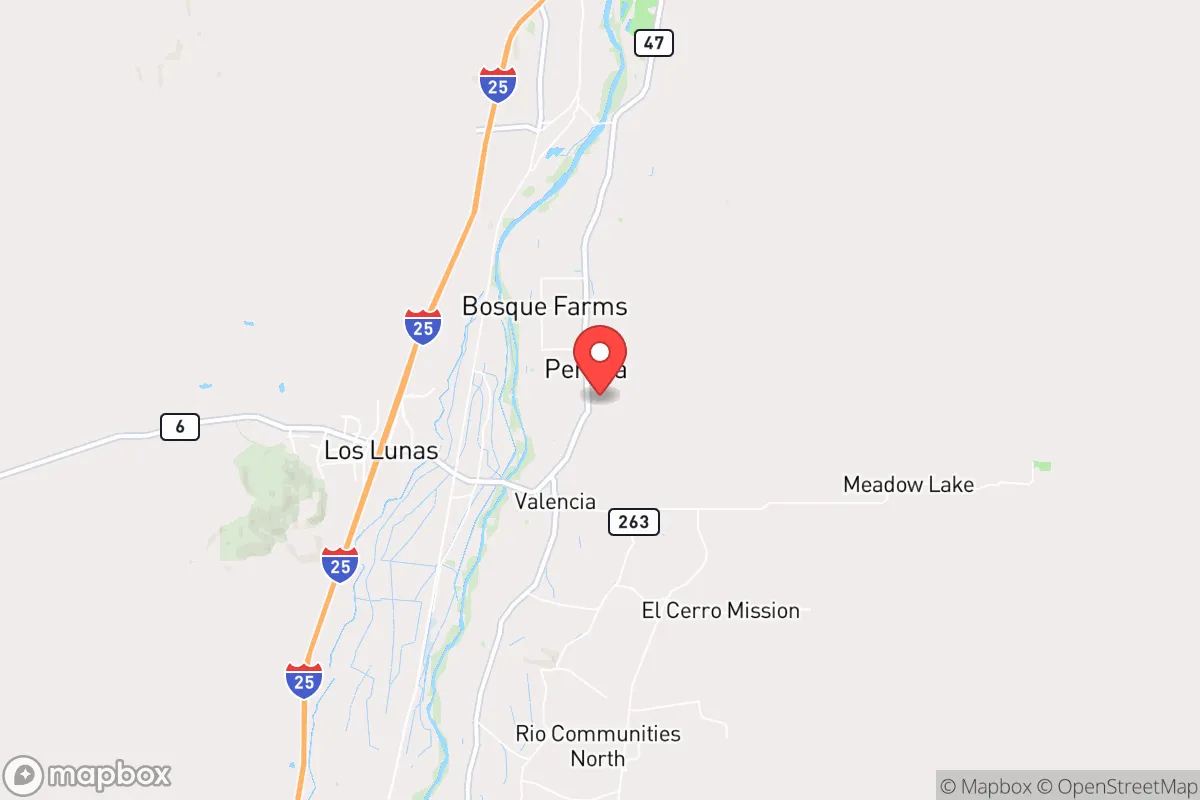
Strategic Assessment of Peralta, NM
Meaningful friction. Expect exposure to either population pressure, blast zones, or natural disaster risk. Consider buying a retreat property.
What does the Strategic Assessment tell us?
Our Strategic Assessment grades tactical survivability of an area. Major population centers, military targets, fallout zones, natural disasters, and border exposure all drive risk — lower exposure means a more defensible position in a crisis.
This is heavily inspired by Joel Skousen's Strategic Relocation book. Highly recommended you checkout the book ($)What does this tell us?
Our Strategic Assessment grades tactical survivability of an area. Major population centers, military targets, fallout zones, natural disasters, and border exposure all drive risk — lower exposure means a more defensible position in a crisis.
This is heavily inspired by Joel Skousen's Strategic Relocation book. Highly recommended you checkout the book ($)Strategic Pillars

Key Distances
Regional Safe Places
Below is our recommended "safe zones" in New Mexico and the surrounding area based on our strategic heuristics. For most people, it's unrealistic to live in a “safe zone” full-time due to work, family or other personal reasons. They tend to be more rural. However, many of these areas are perfect for second homes and retreat properties that double as a vacation home or even a short-term rental.

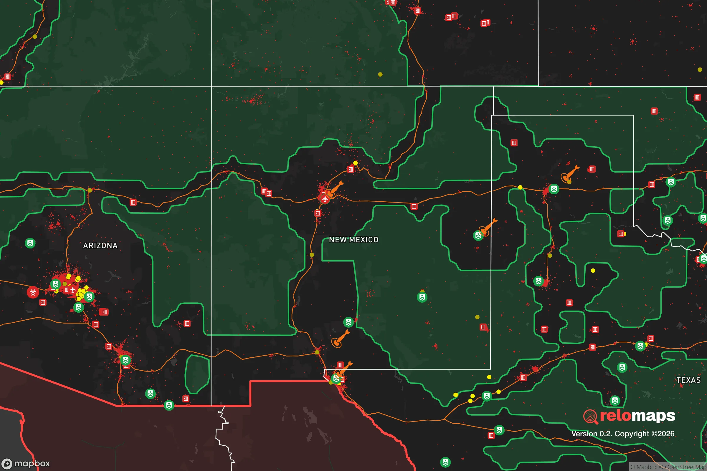
Important Note: For informational purposes only. This does not mean nothing bad ever happens in the green zones. Please use common sense. This is based on public data and modeled with AI. We tried to take a conservative approach but mistakes happen. We update this regularly as new information becomes available.
Solar Generator Recommendations
Backup power matters more here than in safer locations. We've picked three solar generators across budgets and capacity tiers — start with the budget unit if you only need a few essentials, or step up if you want to run a fridge and HVAC for days at a time.

Jackery Portable Power Station Explorer 300
Budget OptionPower on the Go: Weighing only 11 lbs, it's convenient to set up and store with book-sized foldable solar panels

BLUETTI Portable Power Station AC180
Designed for both indoor and outdoor scenarios, AC180 is highly capable as it has a robost capacity and continuous output power.

EF ECOFLOW DELTA Pro Ultra Power Station
Upgraded PickEcoFlow DELTA Pro Ultra is a whole-home energy system designed to grow with your family. Integrated with the Smart Home Panel 2, it scales to meet your evolving energy needs — keeping your home powered, intelligent, and secure through every stage of life.
We earn a commission, at no additional cost to you.
Strategic Assessment Analysis
Peralta, New Mexico, sits in a position that demands serious strategic consideration for anyone looking to relocate with resilience and self-sufficiency in mind. Located just south of Albuquerque along the Rio Grande Valley, this unincorporated community offers a blend of rural quiet and proximity to critical infrastructure, but it also carries significant exposure risks that a prepper cannot ignore. The area’s long-term viability hinges on its ability to buffer against both natural disasters and man-made chaos, and the calculus is not straightforward—Peralta is not a remote bunker, but it is not a sprawling urban target either. For a conservative-leaning individual or family weighing the trade-offs of escape distance versus logistical support, this is a place that demands a clear-eyed look at both its defensive strengths and its glaring vulnerabilities.
Geographic position and natural advantages for long-term survival
Peralta’s location in Valencia County places it roughly 20 miles south of Albuquerque’s urban core, a distance that provides a meaningful buffer against the immediate fallout of a major city event—whether that be a terrorist strike, grid-down scenario, or civil unrest. The community itself is small, with a population under 4,000, which reduces the likelihood of being caught in a mass panic or resource rush. The Rio Grande Valley offers a reliable surface water source, a critical asset in any long-term survival plan, though it requires treatment and is subject to seasonal fluctuations. The surrounding terrain is high desert, with elevations around 4,800 feet, providing a moderate climate that avoids the extreme heat of southern New Mexico and the brutal cold of the northern mountains. This makes year-round gardening possible with proper water management, and the area’s agricultural history—Peralta sits in a region known for chile, alfalfa, and pecan farming—means the soil is workable for those willing to put in the labor. The nearby Manzano Mountains to the east offer potential retreat zones, with forested areas that could serve as bug-out locations if Peralta itself becomes compromised. For a relocator, the key advantage here is that you are not isolated from supply lines—Interstate 25 runs through the area, giving access to both Albuquerque and points south like Las Cruces and El Paso—but you are far enough off the main drag to avoid being a primary target.
Risks, exposures, and proximity to fallout-relevant landmarks
The most serious downside to Peralta is its proximity to Kirtland Air Force Base and Sandia National Laboratories, both located in Albuquerque. These are high-value strategic targets in any major conflict, and a direct strike or even a secondary event—like a conventional attack on the labs’ nuclear weapons research facilities—could produce significant fallout or cascading disruptions. Peralta is within the 20- to 30-mile radius that would be considered a danger zone for radioactive debris or electromagnetic pulse effects, depending on the weapon type. Additionally, the Rio Grande Valley is a natural corridor for transportation and infrastructure, which means it could become a chokepoint during a mass evacuation or a target for sabotage. The area is also prone to drought and wildfire, with the 2022 Calf Canyon/Hermits Peak Fire burning over 340,000 acres in the nearby Sangre de Cristo Mountains—a reminder that natural disasters can strike even in the desert. Flooding along the Rio Grande is a periodic concern, though Peralta sits on slightly higher ground than some neighboring communities. For a prepper, the calculus is this: you are close enough to a major city to be affected by its collapse, but far enough that you might have time to react—provided you have a plan and the means to execute it. The presence of the Albuquerque International Sunport and major rail lines also means the area could see significant refugee movement during a crisis, straining local resources.
Practical resilience for a relocator: food, water, energy, and defensibility
Water is the first and most critical factor. The Rio Grande provides a surface source, but it is heavily managed by the Middle Rio Grande Conservancy District, and during drought years, allocations are cut. A well is the best bet for long-term independence, and many properties in Peralta already have them, with depths typically ranging from 100 to 300 feet. Solar energy is viable here—the area averages over 280 sunny days per year—and off-grid setups are common among the more self-reliant residents. Food production is feasible but requires effort: the growing season runs from April to October, and with drip irrigation and raised beds, a family can produce a significant portion of its own vegetables. Local farmers’ markets in nearby Los Lunas and Belen provide backup supply chains, but in a grid-down scenario, those will dry up fast. Defensibility is a mixed bag. Peralta is not a gated community; it is a spread-out rural area with a mix of acreage and smaller lots. A property with a good setback from the road, natural cover from cottonwoods or junipers, and a clear line of sight to approach routes is ideal. The local law enforcement presence is limited—Valencia County Sheriff’s Office covers a large area—so self-reliance on security is a must. The community itself is politically mixed, but there is a strong conservative undercurrent, with many residents owning firearms and practicing a live-and-let-live attitude. That said, the area is not a prepper enclave; you will not find a network of like-minded survivalists here, so building relationships will take effort. For a single individual or a family, the practical takeaway is that Peralta offers a solid foundation for a resilient lifestyle, but it requires upfront investment in water, energy, and security infrastructure to be truly viable in a crisis.
The overall strategic picture for Peralta is one of cautious viability. It is not a remote stronghold like the Idaho panhandle or the Montana Rockies, but it offers a middle ground that balances access to resources with a degree of separation from the most likely flashpoints. The proximity to Albuquerque is a double-edged sword: it provides supply lines and medical access in normal times, but it becomes a liability during a major event. For a conservative relocator who wants to be prepared for civic unrest or a mass casualty scenario, Peralta works best as a base that is already hardened—meaning you need to have your water, power, and food systems in place before anything happens. The area’s agricultural heritage and climate are genuine assets, but the risks from nearby strategic targets and the potential for refugee flows cannot be dismissed. If you are willing to put in the work and accept that you are not truly off the grid, Peralta can be a defensible, productive place to ride out the storm. If you are looking for absolute isolation and zero risk, keep driving north.
* Values derived from national, state, county, city and local statistics and may differ in a specific area. Last updated: 2026-05-01T04:03:06.000Z
Narrative content on this page is AI-generated and may contain mistakes. Verify any details that matter before acting on them.
ReloMaps may earn a commission from affiliate links at no extra cost to you.