
Photo: Wikipedia
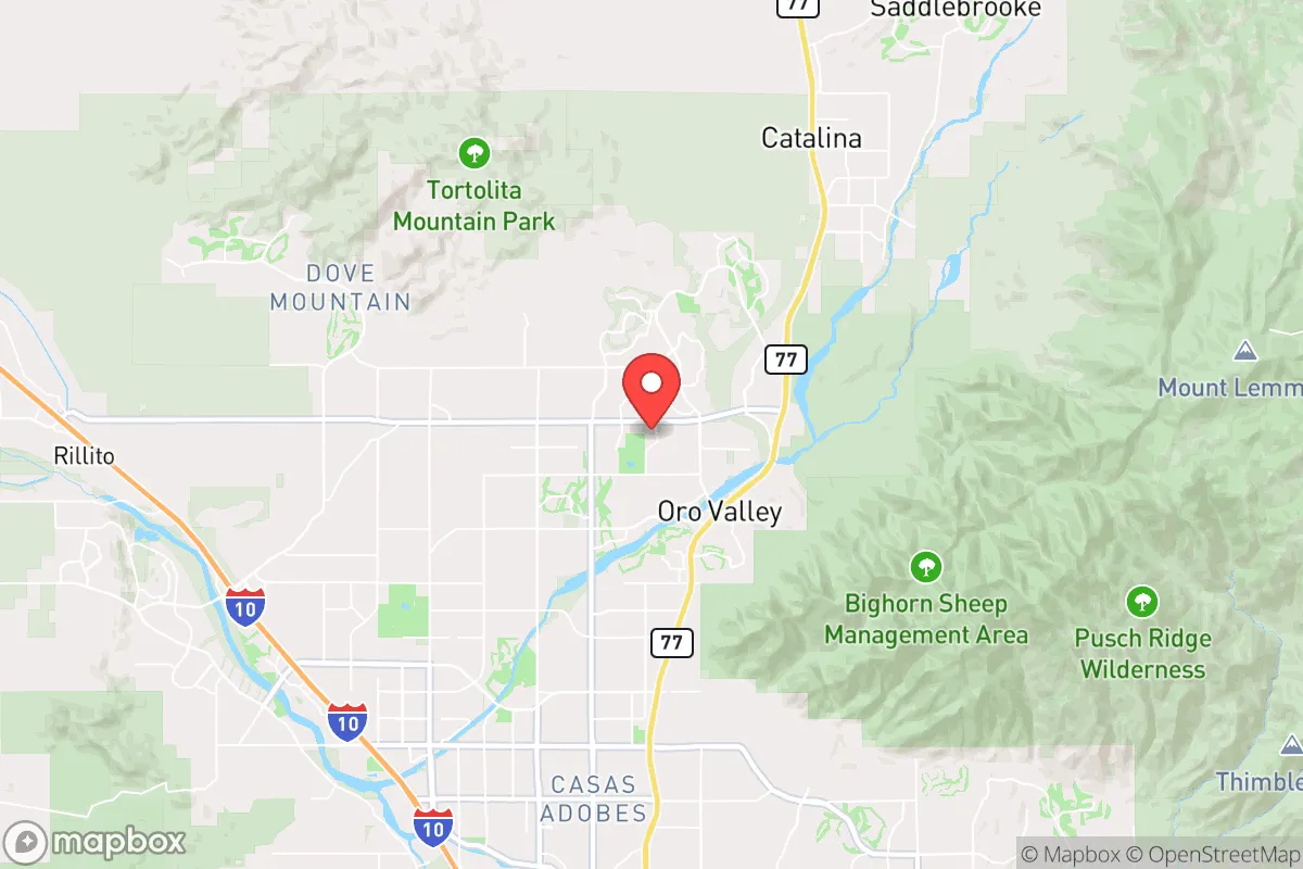
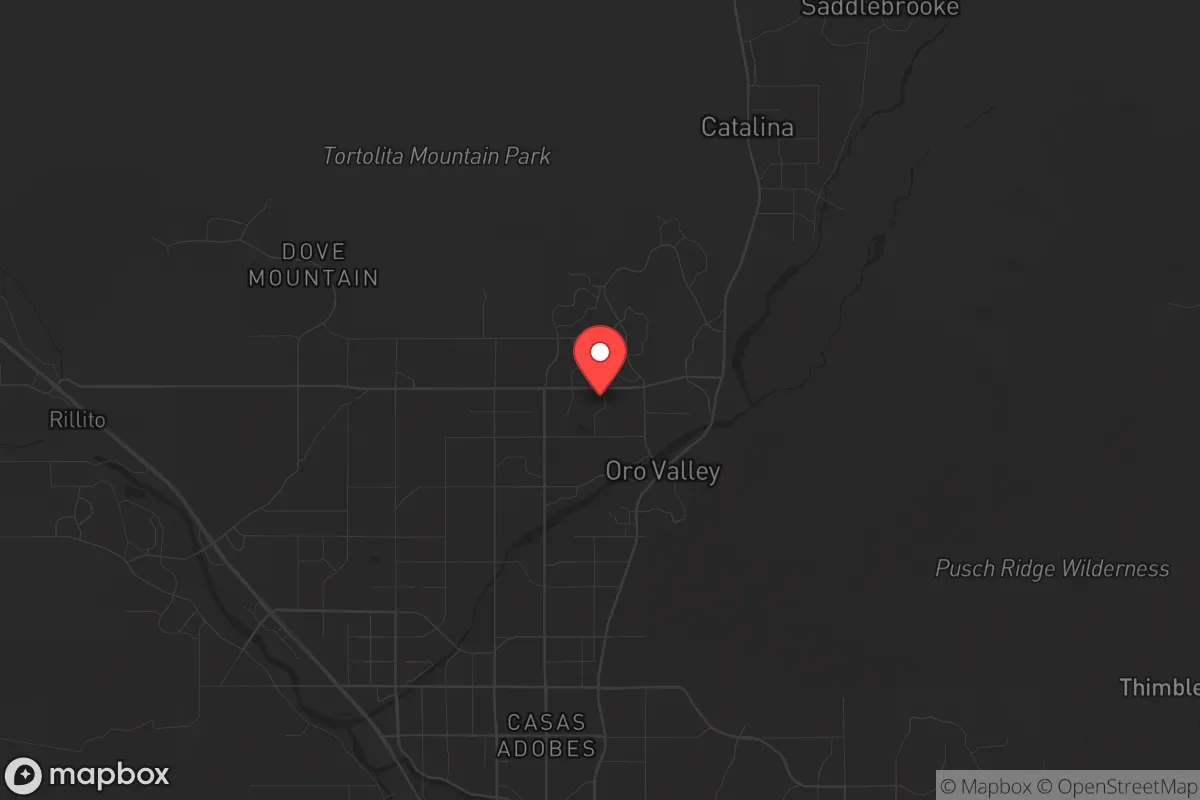
Strategic Assessment of Oro Valley, AZ
Multiple tactical vulnerabilities. Population density, target proximity, or disaster risk are likely compounding. A retreat property and exit planning is required.
What does the Strategic Assessment tell us?
Our Strategic Assessment grades tactical survivability of an area. Major population centers, military targets, fallout zones, natural disasters, and border exposure all drive risk — lower exposure means a more defensible position in a crisis.
This is heavily inspired by Joel Skousen's Strategic Relocation book. Highly recommended you checkout the book ($)What does this tell us?
Our Strategic Assessment grades tactical survivability of an area. Major population centers, military targets, fallout zones, natural disasters, and border exposure all drive risk — lower exposure means a more defensible position in a crisis.
This is heavily inspired by Joel Skousen's Strategic Relocation book. Highly recommended you checkout the book ($)Strategic Pillars

Key Distances
Regional Safe Places
Below is our recommended "safe zones" in Arizona and the surrounding area based on our strategic heuristics. For most people, it's unrealistic to live in a “safe zone” full-time due to work, family or other personal reasons. They tend to be more rural. However, many of these areas are perfect for second homes and retreat properties that double as a vacation home or even a short-term rental.
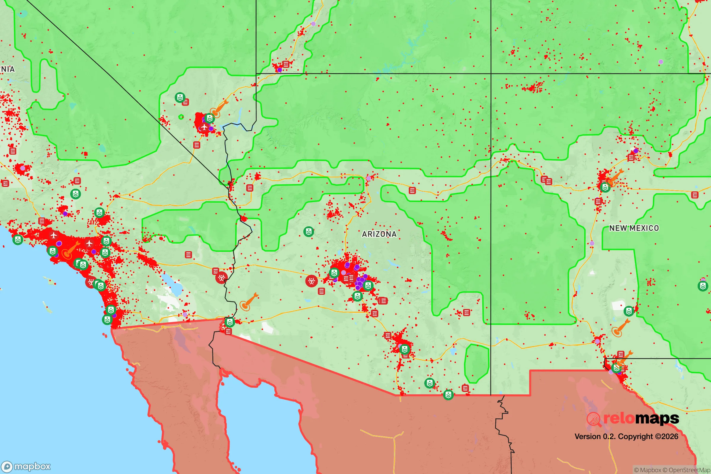
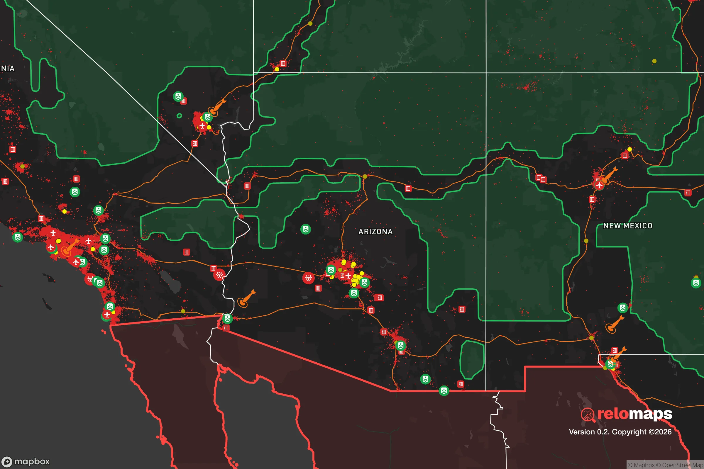
Important Note: For informational purposes only. This does not mean nothing bad ever happens in the green zones. Please use common sense. This is based on public data and modeled with AI. We tried to take a conservative approach but mistakes happen. We update this regularly as new information becomes available.
Solar Generator Recommendations
Backup power matters more here than in safer locations. We've picked three solar generators across budgets and capacity tiers — start with the budget unit if you only need a few essentials, or step up if you want to run a fridge and HVAC for days at a time.

Jackery Portable Power Station Explorer 300
Budget OptionPower on the Go: Weighing only 11 lbs, it's convenient to set up and store with book-sized foldable solar panels

BLUETTI Portable Power Station AC180
Designed for both indoor and outdoor scenarios, AC180 is highly capable as it has a robost capacity and continuous output power.

EF ECOFLOW DELTA Pro Ultra Power Station
Upgraded PickEcoFlow DELTA Pro Ultra is a whole-home energy system designed to grow with your family. Integrated with the Smart Home Panel 2, it scales to meet your evolving energy needs — keeping your home powered, intelligent, and secure through every stage of life.
We earn a commission, at no additional cost to you.
Strategic Assessment Analysis
Oro Valley, Arizona, sits in a unique strategic pocket that balances proximity to critical infrastructure with enough geographic buffer to make it a serious relocation candidate for those prioritizing resilience. Nestled at the northwest edge of the Tucson metro area, this community of roughly 45,000 offers a blend of suburban amenities and access to the Sonoran Desert’s natural barriers, but it’s not without its exposures. For a conservative-leaning individual or family thinking about long-term preparedness—civic unrest, supply chain disruptions, or larger-scale events—this area demands a clear-eyed look at both its defensive strengths and its vulnerabilities.
Geographic position and natural advantages for long-term security
Oro Valley’s location at the base of the Santa Catalina Mountains provides a natural defensive backdrop that’s hard to overstate. The Catalina State Park and Coronado National Forest to the north and east create a rugged, sparsely populated buffer zone—terrain that would slow any large-scale movement and offer escape routes into high country if needed. The town sits at roughly 2,600 feet elevation, which means milder summers than Tucson proper and a lower risk of the extreme heat that plagues lower desert areas. Water is the perennial concern in Arizona, but Oro Valley sits atop the Avra Valley aquifer and has secured long-term water rights through the Central Arizona Project, giving it a more stable supply than many desert communities. The nearby Tortolita Mountains to the west add another layer of separation from the sprawl of Marana and Tucson, creating a natural choke point along Oracle Road, the primary north-south corridor. For a relocator, this means you’re not boxed in—you have multiple directions to move if things go sideways, and the terrain itself works in your favor.
Risks, exposures, and proximity to fallout-relevant landmarks
Let’s be blunt: Oro Valley is not a bunker. It’s 20 miles north of Davis-Monthan Air Force Base, a major strategic asset that houses the 355th Wing and the 12th Air Force. In a major conflict, that base is a target—and while Oro Valley is far enough to avoid a direct blast zone, fallout patterns depend on wind direction. Prevailing winds in southern Arizona run west to east, meaning a strike on Davis-Monthan would push contamination toward the Rincon Mountains and away from Oro Valley, but that’s a statistical comfort, not a guarantee. The Tucson International Airport and the Raytheon missile plant (a key defense contractor) are also within 25 miles, adding to the region’s strategic value and thus its risk profile. On the plus side, Oro Valley is far from the major ports, nuclear power plants, and dense urban corridors of the East and West Coasts. The nearest nuclear facility is the Palo Verde Generating Station near Phoenix, about 100 miles northwest—outside the typical 50-mile emergency planning zone. For civic unrest, Oro Valley’s relative affluence and low crime rate (violent crime is roughly 60% below the national average) mean it’s less likely to see the kind of street-level chaos that could engulf larger cities. But it’s not immune: the town’s main evacuation route, Oracle Road (AZ-77), is a two-lane road in many stretches, and a mass exodus from Tucson could turn it into a parking lot. Anyone serious about resilience should have alternate routes mapped—via Golder Ranch Road to the east or through the Tortolita foothills to the west.
Practical resilience for a relocator: food, water, energy, and defensibility
Water is the first thing to nail down. Oro Valley’s municipal supply is sourced from groundwater and CAP allocations, but the town has a tiered water rate structure that encourages conservation—meaning heavy usage (like filling a large garden or pool) gets expensive fast. For a prepper, this means you’ll want a property with a well, or at least a rainwater harvesting system. The area gets about 12 inches of rain annually, mostly during the monsoon season (July–September), so a 1,000-square-foot roof can capture roughly 7,500 gallons per year—enough for basic household use if stored properly. Solar is a no-brainer here: Oro Valley averages 350+ sunny days per year, and the town has net metering policies that make grid-tied solar viable. Off-grid solar is also feasible, though HOA restrictions in many subdivisions can be a headache—look for properties in unincorporated Pima County or older neighborhoods with fewer covenants. Food production is limited by the arid climate, but the growing season is long (February through November) and raised beds with drip irrigation can yield significant produce. The local farmers’ market at Oro Valley Marketplace is decent for seasonal produce, but for bulk storage, you’ll want to drive to Tucson’s Costco or Sam’s Club—both about 20 minutes south. Defensibility is mixed: most neighborhoods are suburban grids with multiple entry points, but the Catalina foothills offer more secluded parcels with long driveways and natural sightlines. The Pima County Sheriff’s Office has a substation in Oro Valley, and response times are generally under 10 minutes, but in a widespread event, you’re on your own. The town’s population is older and more conservative than the national average—median age is 50, and the 2024 election saw Pima County go blue, but Oro Valley itself leans red—which means a higher likelihood of neighbors who are armed and share your worldview. That’s a soft factor, but in a breakdown scenario, community cohesion is everything.
The overall strategic picture for Oro Valley is one of calculated trade-offs. It offers genuine natural defenses, a stable water supply relative to the region, and a demographic profile that aligns with self-reliance and mutual aid. But it sits within striking distance of multiple high-value military and industrial targets, and its evacuation infrastructure is fragile. For a single individual or family willing to invest in water storage, solar, and a well-chosen property in the foothills, this is a solid base of operations—not a fortress, but a defensible outpost with access to the resources of a mid-sized city without being swallowed by it. The key is to treat Oro Valley as a staging area, not a final redoubt. Have a bug-out plan for the mountains to the north, keep your vehicle gassed up, and build relationships with your neighbors before you need them. In a world that’s trending toward instability, this town gives you a fighting chance—but only if you take the preparation seriously.
* Values derived from national, state, county, city and local statistics and may differ in a specific area. Last updated: 2026-05-03T20:23:57.000Z
Narrative content on this page is AI-generated and may contain mistakes. Verify any details that matter before acting on them.
ReloMaps may earn a commission from affiliate links at no extra cost to you.