
Photo: Wikipedia
Strategic Assessment of North Carolina
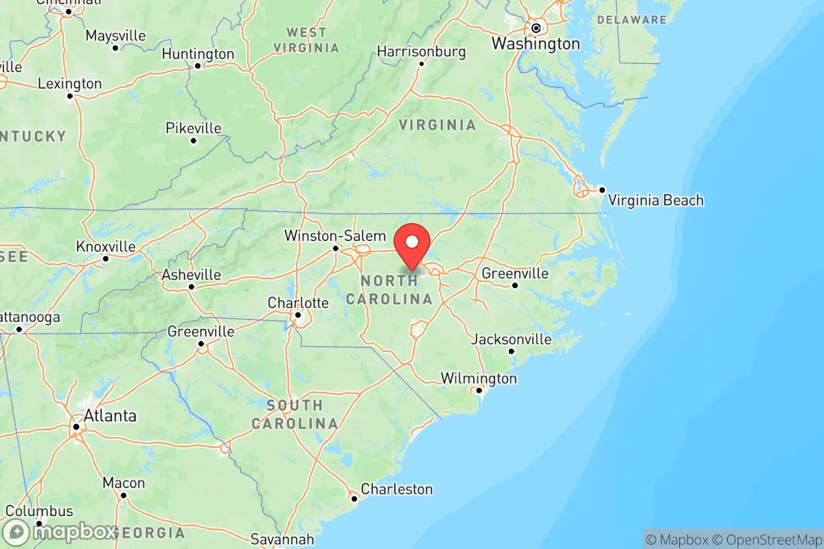
Meaningful friction. Expect exposure to either population pressure, blast zones, or natural disaster risk. Consider buying a retreat property.
What does the Strategic Assessment tell us?
Our Strategic Assessment grades tactical survivability of an area. Major population centers, military targets, fallout zones, natural disasters, and border exposure all drive risk — lower exposure means a more defensible position in a crisis.
This is heavily inspired by Joel Skousen's Strategic Relocation book. Highly recommended you checkout the book ($)What does this tell us?
Our Strategic Assessment grades tactical survivability of an area. Major population centers, military targets, fallout zones, natural disasters, and border exposure all drive risk — lower exposure means a more defensible position in a crisis.
This is heavily inspired by Joel Skousen's Strategic Relocation book. Highly recommended you checkout the book ($)Regional Safe Places
Below is our recommended "safe zones" in North Carolina and the surrounding area based on our strategic heuristics. For most people, it's unrealistic to live in a “safe zone” full-time due to work, family or other personal reasons. They tend to be more rural. However, many of these areas are perfect for second homes and retreat properties that double as a vacation home or even a short-term rental.


Important Note: For informational purposes only. This does not mean nothing bad ever happens in the green zones. Please use common sense. This is based on public data and modeled with AI. We tried to take a conservative approach but mistakes happen. We update this regularly as new information becomes available.
Solar Generator Recommendations
Backup power matters more here than in safer locations. We've picked three solar generators across budgets and capacity tiers — start with the budget unit if you only need a few essentials, or step up if you want to run a fridge and HVAC for days at a time.

Jackery Portable Power Station Explorer 300
Budget OptionPower on the Go: Weighing only 11 lbs, it's convenient to set up and store with book-sized foldable solar panels

BLUETTI Portable Power Station AC180
Designed for both indoor and outdoor scenarios, AC180 is highly capable as it has a robost capacity and continuous output power.

EF ECOFLOW DELTA Pro Ultra Power Station
Upgraded PickEcoFlow DELTA Pro Ultra is a whole-home energy system designed to grow with your family. Integrated with the Smart Home Panel 2, it scales to meet your evolving energy needs — keeping your home powered, intelligent, and secure through every stage of life.
We earn a commission, at no additional cost to you.
Strategic Assessment Analysis
North Carolina offers a compelling mix of geographic insulation and logistical access that makes it a serious contender for anyone prioritizing long-term stability and self-reliance. The state sits far enough from the major fault lines of the Eastern Seaboard—both literal and political—to avoid the worst of coastal storm surges and the immediate fallout of a major urban crisis, yet it remains connected to critical supply chains via I-95, I-40, and the Port of Wilmington. For a relocator with a conservative, preparedness-minded outlook, the key question isn’t whether North Carolina is perfect—it’s whether its risks are manageable and its advantages outweigh the trade-offs. The answer, with careful site selection, leans yes.
Geographic position and natural advantages for long-term security
North Carolina’s geography is a strategic asset in ways that flat, coastal states simply cannot match. The state spans three distinct regions—the Coastal Plain, the Piedmont, and the Appalachian Mountains—which means a relocator can choose a microclimate and terrain that suits their defensibility needs. The Blue Ridge and Great Smoky Mountains in the western part of the state offer rugged terrain, abundant natural water sources, and elevation that provides both a tactical advantage and a buffer against sea-level rise or hurricane storm surge. Towns like Boone, Asheville, and Hendersonville sit at 2,000–3,000 feet, with cooler summers and access to national forest land that limits dense development. The Piedmont region, including areas around Raleigh and Greensboro, offers a balance of agricultural land and manufacturing infrastructure without the density of a megacity. The state’s coastline, while vulnerable, is less exposed than Florida’s or the Gulf Coast’s, and the Outer Banks act as a natural barrier island system that absorbs the first punch of Atlantic storms. For a prepper, the ability to retreat westward into the mountains while maintaining a foothold in the Piedmont’s resource-rich corridor is a significant strategic advantage.
Risks, exposures, and proximity to fallout-relevant landmarks
No state is a fortress, and North Carolina has its share of vulnerabilities that a serious relocator must weigh. The most obvious risk is hurricanes: the eastern third of the state, including cities like Wilmington and Greenville, has been hammered by storms like Florence (2018) and Matthew (2016), which caused catastrophic flooding and prolonged power outages. But the bigger concern for a survivalist mindset is proximity to high-value targets and choke points. Fort Liberty (formerly Fort Bragg), the largest military base in the U.S. by population, sits just outside Fayetteville. In a major conflict or domestic disruption, that area becomes a primary logistical hub and a potential target for both kinetic and cyber attacks. Similarly, the Port of Wilmington handles a massive volume of container traffic and is a critical node for fuel and goods distribution—any disruption there ripples across the state. The Harris Nuclear Plant near New Hill and the McGuire Nuclear Station near Charlotte are both within 20–30 miles of major population centers; while modern reactors are hardened, a worst-case event would put large swaths of the Piedmont at risk. For those seeking true isolation, staying at least 50 miles from these landmarks is advisable. The I-95 corridor, which runs through the state from the Virginia line to South Carolina, is a perennial chokepoint for traffic and supply lines—any major event will see that highway gridlocked within hours.
Practical resilience for a relocator: food, water, energy, and defensibility
North Carolina’s practical resilience comes down to its natural resources and the ability to live off the grid without constant government intervention. Water is abundant: the state averages 45–55 inches of rainfall annually, and the mountain regions are laced with creeks, springs, and rivers like the French Broad and the New River. For a relocator, securing a property with a well and a gravity-fed water system is feasible in most rural counties west of I-95. Food production is equally viable—the Piedmont and western counties have rich soil for gardens, and the state is a top producer of sweet potatoes, poultry, and pork. Local farmers’ markets and cooperative extension services are strong, and many counties have loose zoning that allows for livestock and small-scale agriculture. Energy resilience is mixed: Duke Energy dominates the grid, and power outages from storms or cyberattacks are common in rural areas. Solar is a solid option—the state has decent insolation, especially in the Piedmont—but pairing it with battery storage or a backup generator is essential. Defensibility varies by region. The mountain counties offer natural chokepoints: narrow valleys, single-lane roads, and dense forest that make large-scale movement difficult. Counties like Watauga, Avery, and Mitchell have low population density and a culture of self-reliance that aligns with a preparedness mindset. However, the same terrain that provides cover also limits escape routes—if a crisis forces evacuation, the winding mountain roads can become death traps. The best approach is to choose a property with at least two egress routes and a defensible perimeter, such as a ridge with clear sightlines.
The overall strategic picture for North Carolina is one of high potential with manageable risks—provided you pick the right spot. The state’s political climate leans conservative outside of the urban islands of Charlotte, Raleigh, and Asheville, and the culture in rural areas is generally pro-gun, pro-self-sufficiency, and suspicious of federal overreach. That aligns well with a prepper’s worldview. The downsides—hurricane exposure in the east, proximity to military and nuclear targets, and the vulnerability of the I-95 corridor—are real but can be mitigated by choosing a location in the western Piedmont or lower mountains, ideally at least 60 miles from Fort Liberty and 40 miles from any nuclear plant. For a single individual or a family looking to plant roots in a state that offers both economic opportunity and a fallback position, North Carolina is a solid bet. Just don’t buy on the coast, don’t live within sight of a major base, and make sure your water source is uphill from your neighbor’s septic. That’s the kind of practical thinking that keeps you ahead of the curve.
Top 10 Cities by Strategic Assessment in North Carolina
 1B-
1B- 2C+
2C+ 3C+
3C+ 4C+
4C+ 5C+
5C+ 6C+
6C+ 7C
7C 8C
8C 9C
9C 10C
10C* Values derived from national, state, county, city and local statistics and may differ in a specific area. Last updated: 2026-04-14T06:23:38.000Z
Narrative content on this page is AI-generated and may contain mistakes. Verify any details that matter before acting on them.
ReloMaps may earn a commission from affiliate links at no extra cost to you.