Photo: Wikipedia
Strategic Assessment of Hill County
Strong survivability profile. Good buffer from population centers, with manageable environmental and tactical risks.
What does the Strategic Assessment tell us?
Our Strategic Assessment grades tactical survivability of an area. Major population centers, military targets, fallout zones, natural disasters, and border exposure all drive risk — lower exposure means a more defensible position in a crisis.
This is heavily inspired by Joel Skousen's Strategic Relocation book. Highly recommended you checkout the book ($)What does this tell us?
Our Strategic Assessment grades tactical survivability of an area. Major population centers, military targets, fallout zones, natural disasters, and border exposure all drive risk — lower exposure means a more defensible position in a crisis.
This is heavily inspired by Joel Skousen's Strategic Relocation book. Highly recommended you checkout the book ($)Strategic Pillars

Key Distances
Strategic Assessment Analysis
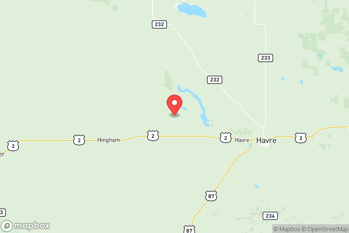
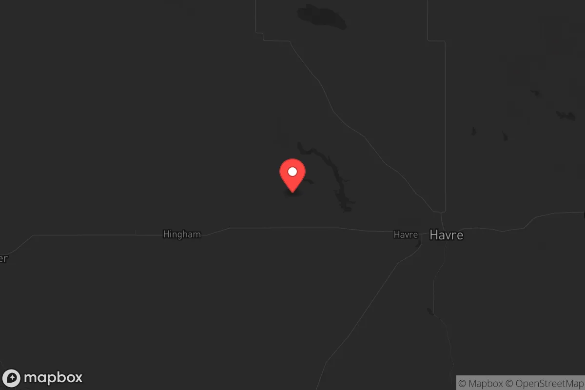
Hill County, Montana, offers a compelling strategic profile for relocators prioritizing resilience and self-sufficiency, combining a remote northern plains location with the practical infrastructure of a regional hub. The county’s seat, Havre, sits roughly 40 miles from the Canadian border and serves as a critical service center for a vast, sparsely populated region, providing a balance of isolation and access that is rare in the lower 48. For those assessing long-term stability, Hill County’s low population density, cold climate, and distance from major metropolitan targets present a strong baseline for disaster preparedness, though the area is not without its own specific exposures.
Geographic position and natural advantages for long-term stability
Hill County’s primary strategic asset is its location within the Hi-Line region, a strip of prairie and agricultural land stretching across northern Montana. The county is far removed from the nation’s major population centers—over 300 miles from Billings, 400 miles from Seattle, and 500 miles from Denver—which inherently reduces exposure to cascading failures from urban grid collapse, pandemics, or large-scale civil unrest. The terrain is predominantly open, rolling plains with the Bear Paw Mountains in the southern portion, offering some natural defensibility and varied microclimates. The Milk River runs through the county, providing a perennial water source that is a significant advantage over many other plains counties. Havre itself sits on a major rail line (BNSF’s northern transcontinental route) and Interstate 15, which runs north-south, giving residents a logistical lifeline for supply movement while still being far enough from the I-15 corridor’s busier southern segments to avoid being a primary chokepoint. The county’s agricultural base—primarily wheat, barley, and cattle—means that local food production is a real, not theoretical, asset, with grain elevators and processing facilities in towns like Havre, Rudyard, and Kremlin.
Risks, exposures, and proximity to fallout-relevant landmarks
While Hill County’s remoteness is a strength, it is not immune to man-made and natural risks that a strategic relocator must weigh. The most significant exposure is the Malmstrom Air Force Base missile field, which extends into the western portion of Hill County. Malmstrom, located near Great Falls about 100 miles southwest, operates Minuteman III intercontinental ballistic missile silos scattered across central Montana. While the silos themselves are hardened and low-yield targets in a full-scale exchange, their presence means the county lies within a potential secondary fallout zone or could experience ground-zero effects from a direct strike on a silo. The exact locations of silos are not public, but the western half of Hill County is within the missile field’s operational area, making that part of the county a higher-risk zone than the eastern half. Additionally, the BNSF rail line through Havre carries hazardous materials, including crude oil from the Bakken formation and refined fuels, creating a localized derailment and fire risk. Natural risks are less dramatic but real: severe winter storms can isolate communities for days, and the region is prone to drought and wildfire, particularly in the Bear Paw Mountains. The county’s flat, open terrain offers little shielding from prevailing winds, which could carry fallout or airborne contaminants from distant events. For a relocator, the key takeaway is that Hill County’s risk profile is dominated by its proximity to strategic military infrastructure, not by urban proximity or industrial corridors like those near Houston or Fort Hood.
Practical resilience for a relocator: food, water, energy, and defensibility
For someone serious about self-sufficiency, Hill County offers a mix of strong fundamentals and notable challenges. Water is the county’s most reliable asset: the Milk River provides a surface water source that, while subject to seasonal low flows and irrigation demands, is supplemented by the St. Mary Canal system and a deep aquifer in the region. Havre’s municipal water supply is treated and reliable, but rural residents typically rely on wells, which can be deep (100-300 feet) but generally produce good-quality water. Food resilience is high due to the agricultural economy; local farmers’ markets, bulk grain purchases, and direct relationships with ranchers are feasible. Havre has several grocery stores, but a strategic relocator would want to establish a network for bulk staples like wheat, oats, and beef. Energy is a mixed picture: the county is served by Northwestern Energy, with electricity primarily from coal and hydroelectric sources, but grid reliability in winter storms is moderate. Solar potential is good—the region averages over 200 sunny days per year—but winter daylight hours are short (around 8 hours in December), and snow cover can reduce panel output. Wood heating is viable in the Bear Paw foothills but less so on the open prairie. Defensibility is low in the traditional sense—the terrain is open and offers few natural chokepoints—but the low population density (about 5 people per square mile) means that a well-prepared group with a rural property can maintain a low profile. The county’s culture is one of self-reliance; many residents already keep gardens, hunt, and store supplies, which means a relocator will find a community that understands preparedness rather than one that is hostile to it. The biggest practical hurdle is the climate: winter temperatures can drop below -30°F, and heavy snow can make travel impossible for days, requiring a robust heating system, a four-wheel-drive vehicle, and a well-stocked pantry.
Overall, Hill County presents a strong strategic option for a relocator who values isolation, agricultural self-sufficiency, and a low-risk profile relative to urban and industrial targets, but who is willing to accept the trade-offs of a harsh climate and proximity to a missile field. The county is not a fallout-free zone—the western half’s proximity to Malmstrom’s silos is a real consideration—but for those willing to locate in the eastern half or near the Bear Paw Mountains, the risk is manageable. The combination of a reliable water source, local food production, and a culture of self-reliance makes it one of the more viable locations in the northern plains for long-term resilience. A relocator should prioritize securing a property with a well, a wood or propane heating backup, and a plan for winter isolation, while staying informed about the specific locations of missile silos in the area. Hill County is not a bug-out location for a weekend prepper; it is a place for someone ready to commit to a hard, independent life in a community that already lives that way.
* Values derived from national, state, county, city and local statistics and may differ in a specific area. Last updated: 2026-06-11T20:29:00.000Z
Narrative content on this page is AI-generated and may contain mistakes. Verify any details that matter before acting on them.
ReloMaps may earn a commission from affiliate links at no extra cost to you.