
Photo: Mike Gattorna via Unsplash
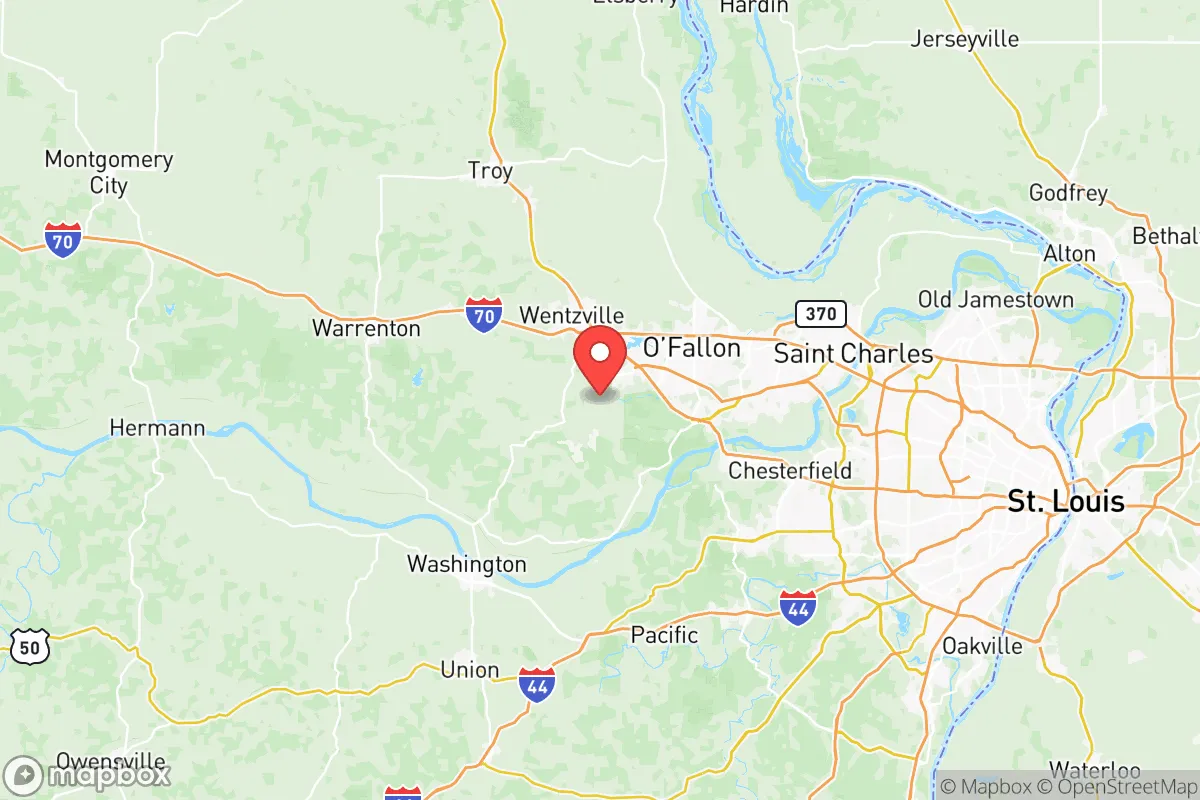
Strategic Assessment of St Charles County
Workable tactical position. Some exposure to population density or targets, but generally defensible in a crisis.
What does the Strategic Assessment tell us?
Our Strategic Assessment grades tactical survivability of an area. Major population centers, military targets, fallout zones, natural disasters, and border exposure all drive risk — lower exposure means a more defensible position in a crisis.
This is heavily inspired by Joel Skousen's Strategic Relocation book. Highly recommended you checkout the book ($)What does this tell us?
Our Strategic Assessment grades tactical survivability of an area. Major population centers, military targets, fallout zones, natural disasters, and border exposure all drive risk — lower exposure means a more defensible position in a crisis.
This is heavily inspired by Joel Skousen's Strategic Relocation book. Highly recommended you checkout the book ($)Strategic Pillars

Key Distances
Strategic Assessment Analysis
St Charles County, Missouri, occupies a strategic sweet spot that few other regions can match: it sits far enough from the nation’s most volatile urban cores to avoid the worst of civic unrest, yet close enough to a major metro—St. Louis—to access critical infrastructure, medical centers, and supply chains. The county’s population has grown steadily, topping 400,000 residents, and its economic base is diversified enough that a single factory closure or supply-chain shock won’t crater the local economy. For a relocator thinking in terms of decades, not quarters, this is the kind of place where you can build a life that doesn’t hinge on the whims of coastal elites or the next federal bailout.
Geographic position and natural buffers: why this corner of Missouri stands apart
St Charles County is anchored by the Missouri River to its south and the Mississippi River to its east, creating a natural moat that slows movement and provides a defensible perimeter. The county’s western and northern edges are rolling farmland and hardwood forest, not suburban sprawl—meaning you’ve got room to breathe and a buffer against the kind of population-density chaos that turns a city into a powder keg. The towns of Wentzville, O’Fallon, and St. Peters form a spine of moderate-density development, but beyond them, places like Augusta, Defiance, and Foristell are genuinely rural, with acreage, well water, and septic systems that don’t depend on municipal grids. The Missouri River bluffs south of Washington, Missouri (just across the county line) offer elevation and natural cover, while the Katy Trail—a 240-mile rail-trail—doubles as a potential evacuation corridor or resupply route if roads get clogged. The county’s position roughly 250 miles from Chicago, 200 miles from Kansas City, and 30 miles from downtown St. Louis means you’re close enough to tap urban resources but far enough that a riot in Ferguson or a protest in downtown St. Louis won’t spill into your backyard.
Risks, exposures, and proximity to fallout-relevant landmarks
No location is risk-free, and St Charles County has its share of exposure. The most obvious concern is the Callaway Nuclear Plant, located about 40 miles west of the county in Fulton, MO. While that’s outside the typical 10-mile emergency planning zone, a major containment failure—think Fukushima-level—could send a plume drifting eastward over the Missouri River valley. The county also sits within 50 miles of the St. Louis Lambert International Airport and the St. Louis Downtown Airport, both of which could become choke points or targets during a mass-casualty event. On the industrial side, the Wood River Refinery complex in Illinois, just across the Mississippi, is a major petroleum hub; a fire, explosion, or deliberate attack there could send toxic smoke across the river and disrupt fuel supplies for weeks. The county’s own General Motors plant in Wentzville is a large employer but also a potential target for labor-related unrest or supply-chain sabotage. Flooding is a recurring natural risk—the Missouri and Mississippi rivers have breached levees multiple times in the past decade, particularly around Portage Des Sioux and West Alton. And while St. Louis itself has seen a decline in violent crime since the 1990s, the city’s homicide rate remains among the highest in the nation; a major civil disturbance there could send thousands of people streaming west across the Blanchette Bridge or the Discovery Bridge, turning I-70 and Highway 364 into parking lots. The county’s law enforcement footprint—the St. Charles County Police Department and the Sheriff’s Office—is well-funded and professional, but a coordinated event involving multiple jurisdictions would stretch them thin.
Practical resilience for a relocator: food, water, energy, and defensibility
For a single individual or a family serious about preparedness, St Charles County offers a mix of advantages and trade-offs. Water is abundant—the Missouri and Mississippi rivers are obvious sources, but the county also sits atop the Missouri River Alluvial Aquifer, meaning shallow wells in the western and southern parts of the county can yield clean water with a hand pump or a solar-powered submersible. The Missouri American Water utility serves most of the county, but a grid-down scenario would leave municipal taps dry; having a backup well or a rainwater catchment system is a smart move. Food production is viable: the county has over 1,200 farms, many of them small operations selling beef, poultry, eggs, and produce at farmers’ markets in St. Charles, O’Fallon, and Wentzville. The St. Charles County Extension Office runs workshops on gardening, canning, and livestock management, which is a low-cost way to build skills. Energy resilience is mixed: the county’s grid is served by Ameren Missouri, which has a decent reliability record but is vulnerable to ice storms and tornadoes. Solar panels are legal and increasingly common, and the county’s zoning codes are generally friendly to backup generators and battery storage. Defensibility varies by location: a rural property with a long driveway, a creek or pond as a natural barrier, and a clear line of sight to the road is far more secure than a subdivision lot in St. Peters or Lake Saint Louis. The county’s topography—rolling hills, wooded draws, and river bluffs—offers plenty of places to set up a retreat that isn’t visible from the main roads. The Weldon Spring Conservation Area and the Augusta Bottoms Conservation Area provide public land for hunting, foraging, and training, though you’ll want to secure private acreage for long-term sustainability.
The overall strategic picture for St Charles County is one of cautious optimism for the prepared relocator. It’s not a bunker—it’s a working, breathing community with schools, hospitals, and a tax base that isn’t dependent on a single industry or a federal grant. The county’s political leanings—consistently Republican in presidential elections, with a strong libertarian streak—mean that local governance tends to favor property rights, low taxes, and minimal interference in personal preparedness. The proximity to St. Louis is a double-edged sword: it gives you access to Level 1 trauma centers, international shipping via Lambert, and a major rail hub, but it also means you’re within a day’s walk of a city that could become a humanitarian disaster zone overnight. If you’re looking for a place where you can raise a family, store supplies, and still drive to a Costco or a hardware store without feeling like you’re in a war zone, St Charles County checks most of the boxes. Just don’t buy a house in a floodplain, keep a bug-out bag with a route that avoids the river crossings, and make friends with a farmer who knows how to run a tractor without GPS. That’s the kind of resilience that no government program can provide.
* Values derived from national, state, county, city and local statistics and may differ in a specific area. Last updated: 2026-05-12T10:43:13.000Z
Narrative content on this page is AI-generated and may contain mistakes. Verify any details that matter before acting on them.
ReloMaps may earn a commission from affiliate links at no extra cost to you.