Photo: Wikipedia
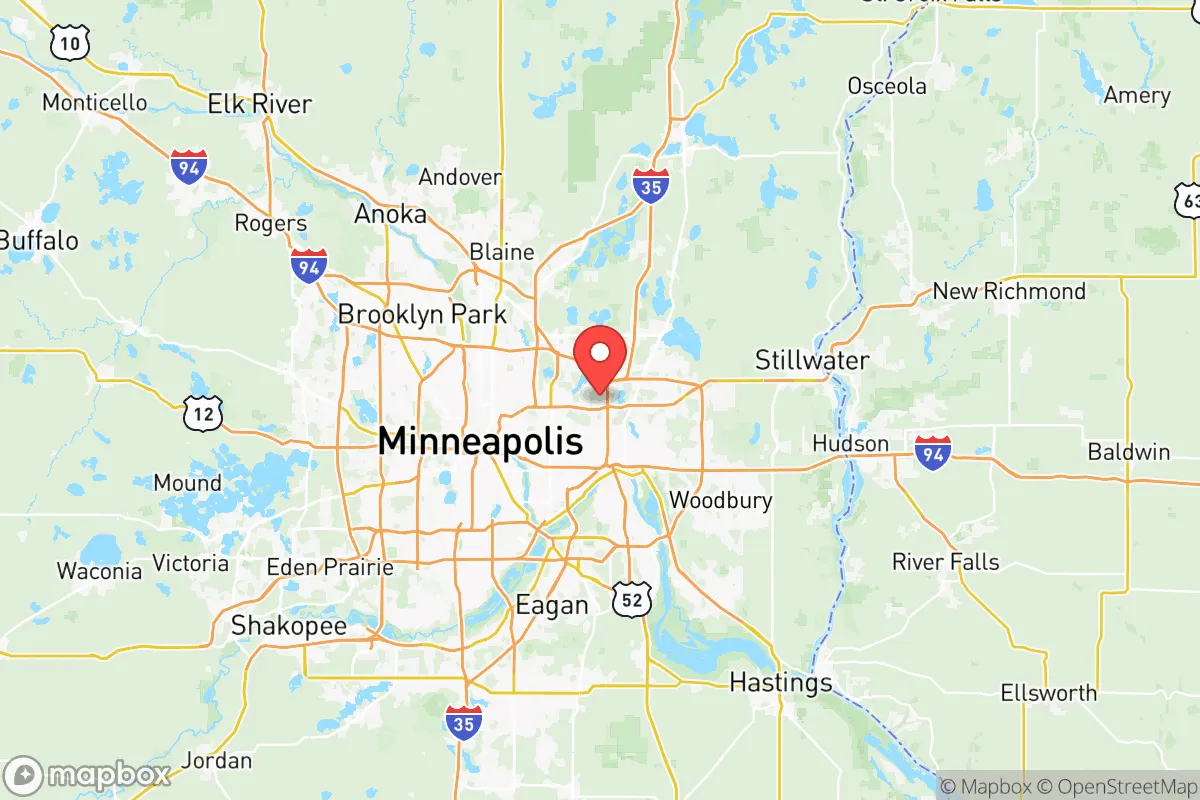
Strategic Assessment of Ramsey County
Multiple tactical vulnerabilities. Population density, target proximity, or disaster risk are likely compounding. A retreat property and exit planning is required.
What does the Strategic Assessment tell us?
Our Strategic Assessment grades tactical survivability of an area. Major population centers, military targets, fallout zones, natural disasters, and border exposure all drive risk — lower exposure means a more defensible position in a crisis.
This is heavily inspired by Joel Skousen's Strategic Relocation book. Highly recommended you checkout the book ($)What does this tell us?
Our Strategic Assessment grades tactical survivability of an area. Major population centers, military targets, fallout zones, natural disasters, and border exposure all drive risk — lower exposure means a more defensible position in a crisis.
This is heavily inspired by Joel Skousen's Strategic Relocation book. Highly recommended you checkout the book ($)Strategic Pillars

Key Distances
Strategic Assessment Analysis
Ramsey County, anchored by Saint Paul and stretching north through suburbs like Shoreview, White Bear Lake, and Maplewood, presents a mixed strategic picture for the relocation-minded reader prioritizing resilience and self-sufficiency. Its location along the Mississippi River and proximity to the Minneapolis-Saint Paul metro core offer economic advantages but also concentrate risk, placing residents within easy reach of multiple high-value targets and potential fallout zones. For a conservative-leaning individual or family weighing disaster readiness, Ramsey County demands a clear-eyed assessment of its geographic strengths, its exposure to man-made and natural hazards, and the practical realities of living there when the grid falters.
Geographic position and natural advantages for resilience
Ramsey County sits at the confluence of the Mississippi, Minnesota, and St. Croix rivers, a water-rich environment that is a genuine asset for long-term survival. The Mississippi River alone provides a massive, reliable freshwater source, and the county's numerous lakes—including White Bear Lake, Bald Eagle Lake, and Lake Johanna—offer distributed water access that reduces dependency on municipal systems. The region's topography is generally flat to gently rolling, with wooded bluffs along the river corridors that provide modest defensible positions and cover. The county's northern reaches, particularly around Shoreview and North Oaks, feature larger lot sizes, forested areas, and lower population density than the urban core, offering more practical space for gardening, rainwater catchment, and off-grid living. Winters are harsh, with average January lows around 10°F and significant snowfall, which acts as a natural barrier to movement and a water source if melted, but also demands serious preparation in terms of heating, shelter, and food storage. The county's position roughly 300 miles from the Canadian border also provides a potential northern retreat corridor, though that distance is significant in a crisis.
Risks, exposures, and proximity to fallout-relevant landmarks
The most significant strategic drawback of Ramsey County is its location within the Minneapolis-Saint Paul metropolitan area, the 16th-largest metro in the United States. Saint Paul itself is the state capital, home to the Minnesota State Capitol complex, the Minnesota National Guard headquarters, and several federal buildings. The county also contains the Saint Paul Downtown Airport (Holman Field) and is within 10 miles of Minneapolis-Saint Paul International Airport (MSP), a major civilian and military airlift hub. These are all plausible targets in a conflict scenario, and their proximity means that fallout patterns could easily affect large portions of the county, especially areas south and east of the urban core. The Mississippi River corridor also hosts several bridges, locks, and dams—including the Ford Dam and Lock and Dam No. 1—that could be targeted to disrupt transportation and power generation. On the natural hazard side, Ramsey County is not in a hurricane or earthquake zone, but it does face tornado risks; the county averages about 2-3 tornado warnings per year, and the 2021 EF-2 tornado that struck near White Bear Lake demonstrated that even suburban areas are not immune. Flooding along the Mississippi and its tributaries is a recurring issue, particularly in low-lying areas of Saint Paul like the Dayton's Bluff and West Side neighborhoods, though modern levees and floodwalls provide substantial protection.
Practical resilience for a relocator: food, water, energy, and defensibility
For a relocator serious about self-sufficiency, Ramsey County offers a mixed bag. Water is abundant, but most residents rely on municipal systems drawing from the Mississippi River or groundwater wells. A private well is feasible in northern and eastern parts of the county, particularly in areas like North Oaks, Gem Lake, and rural pockets of White Bear Township, but much of the county is served by city water. Rainwater collection is legal in Minnesota with a permit for outdoor use, but the long winter freeze limits its practicality for much of the year. Food resilience is moderate: the county has a strong network of farmers' markets, community gardens, and local farms in its northern and eastern edges, but the growing season is short (roughly 140-160 frost-free days). Staple crops like potatoes, squash, and cold-hardy greens are viable, but significant food storage and preservation infrastructure would be needed to get through the winter. Energy resilience is a weak point. The grid is reliable under normal conditions, but the metro area's concentration of demand means that a prolonged outage would strain resources. Solar panels are viable, with the county averaging about 4.5 peak sun hours per day in summer, but winter production drops sharply. Backup generators and wood-burning stoves are common in suburban and rural homes, and firewood is readily available from the county's many wooded areas. Defensibility varies dramatically by neighborhood. The urban core of Saint Paul is dense, with narrow streets and limited sightlines, making it difficult to secure. Suburban areas like Shoreview, Arden Hills, and Vadnais Heights offer more space, cul-de-sacs, and natural chokepoints, but they are still connected by major highways (I-35E, I-694, US-10) that could become avenues for movement in a crisis. The county's many lakes and wetlands also create natural barriers that can be used to control access.
The overall strategic picture for Ramsey County is one of trade-offs. Its water abundance, moderate climate (by northern standards), and access to local food networks are genuine advantages for a prepared household. But its location within a major metro area, proximity to high-value government and transportation infrastructure, and the inherent challenges of a northern winter mean that resilience here requires serious planning and investment. For a relocator willing to live on the county's northern or eastern fringe—places like White Bear Lake, North St. Paul, or the wooded areas near Bald Eagle Lake—the risk profile improves significantly, though it never disappears. Ramsey County is not a bug-out location; it is a place where a disciplined, well-supplied household can ride out many scenarios, but where the urban shadow is always present. Those seeking true isolation and minimal exposure should look farther north or west. But for someone who needs to stay near the metro for work or family but wants to build a resilient home base, Ramsey County offers a workable, if imperfect, foundation.
* Values derived from national, state, county, city and local statistics and may differ in a specific area. Last updated: 2026-06-08T09:45:24.000Z
Narrative content on this page is AI-generated and may contain mistakes. Verify any details that matter before acting on them.
ReloMaps may earn a commission from affiliate links at no extra cost to you.