
Photo: Wikipedia
Strategic Assessment of Mineral Wells, TX
Meaningful friction. Expect exposure to either population pressure, blast zones, or natural disaster risk. Consider buying a retreat property.
What does the Strategic Assessment tell us?
Our Strategic Assessment grades tactical survivability of an area. Major population centers, military targets, fallout zones, natural disasters, and border exposure all drive risk — lower exposure means a more defensible position in a crisis.
This is heavily inspired by Joel Skousen's Strategic Relocation book. Highly recommended you checkout the book ($)What does this tell us?
Our Strategic Assessment grades tactical survivability of an area. Major population centers, military targets, fallout zones, natural disasters, and border exposure all drive risk — lower exposure means a more defensible position in a crisis.
This is heavily inspired by Joel Skousen's Strategic Relocation book. Highly recommended you checkout the book ($)Strategic Pillars

Key Distances
Regional Safe Places
Below is our recommended "safe zones" in Texas and the surrounding area based on our strategic heuristics. For most people, it's unrealistic to live in a “safe zone” full-time due to work, family or other personal reasons. They tend to be more rural. However, many of these areas are perfect for second homes and retreat properties that double as a vacation home or even a short-term rental.


Important Note: For informational purposes only. This does not mean nothing bad ever happens in the green zones. Please use common sense. This is based on public data and modeled with AI. We tried to take a conservative approach but mistakes happen. We update this regularly as new information becomes available.
Solar Generator Recommendations
Backup power matters more here than in safer locations. We've picked three solar generators across budgets and capacity tiers — start with the budget unit if you only need a few essentials, or step up if you want to run a fridge and HVAC for days at a time.

Jackery Portable Power Station Explorer 300
Budget OptionPower on the Go: Weighing only 11 lbs, it's convenient to set up and store with book-sized foldable solar panels

BLUETTI Portable Power Station AC180
Designed for both indoor and outdoor scenarios, AC180 is highly capable as it has a robost capacity and continuous output power.

EF ECOFLOW DELTA Pro Ultra Power Station
Upgraded PickEcoFlow DELTA Pro Ultra is a whole-home energy system designed to grow with your family. Integrated with the Smart Home Panel 2, it scales to meet your evolving energy needs — keeping your home powered, intelligent, and secure through every stage of life.
We earn a commission, at no additional cost to you.
Strategic Assessment Analysis
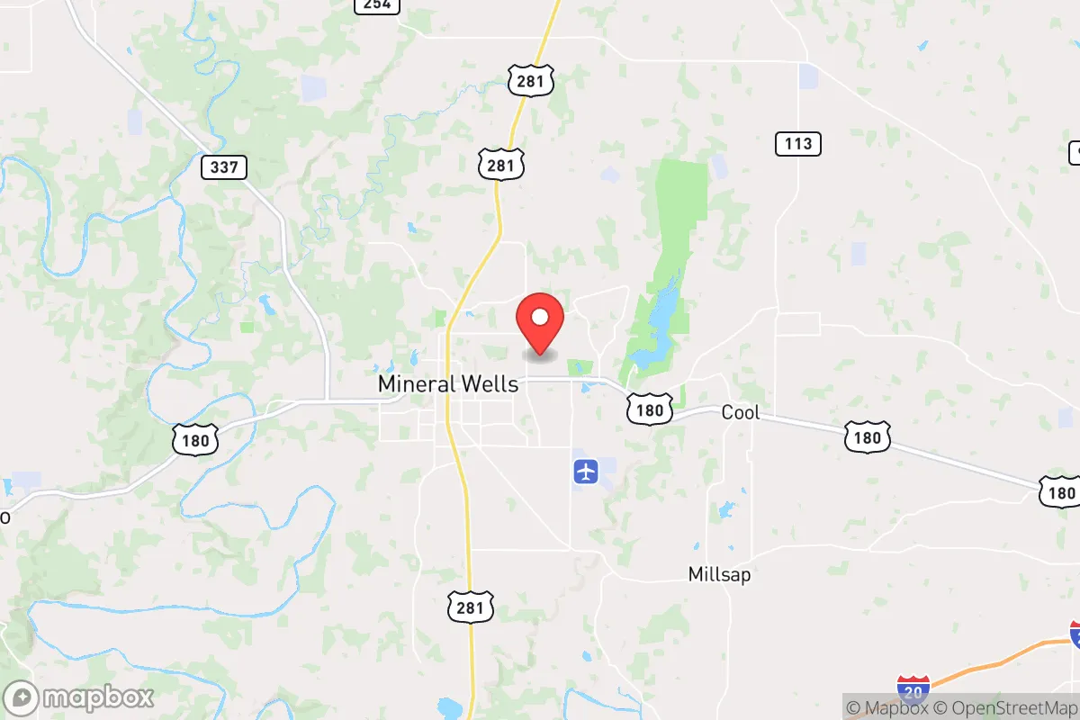
Mineral Wells, Texas, offers a compelling strategic position for those prioritizing resilience and self-sufficiency, sitting roughly 50 miles west of Fort Worth in a region that blends rural buffer with access to critical infrastructure. Its location in Palo Pinto County places it outside the immediate blast and fallout zones of major metropolitan targets like Dallas-Fort Worth, while still being close enough to leverage regional medical and supply networks if they remain functional. The area’s historical identity as a health resort and military training hub gives it a built-in foundation of hard infrastructure—water, rail, and air—that many similarly sized towns lack. For a conservative-leaning relocator concerned with societal fragility, this is not a bug but a feature.
Geographic position and natural advantages for long-term survival
Mineral Wells sits at the edge of the Cross Timbers ecoregion, a transition zone between the rolling plains and the Hill Country, which provides a mix of wooded cover, rocky terrain, and open grazing land. The surrounding Palo Pinto County is sparsely populated—roughly 28,000 residents across 986 square miles—meaning low population density and reduced competition for resources in a crisis. The Brazos River runs just east of town, and Lake Palo Pinto (a 2,700-acre reservoir) lies directly north, offering a reliable surface water source that many West Texas towns lack. The area’s elevation, around 900 feet, and limestone geology provide natural drainage and defensible high ground in certain pockets, particularly near the Brazos River valley. Historically, the region’s mineral springs and mild climate made it a recovery destination; today, that same climate supports year-round gardening and livestock grazing, with an average 200+ growing days per year. For a prepper, this means you can realistically sustain food production without relying on fragile supply chains.
Risks, exposures, and proximity to fallout-relevant landmarks
The primary strategic risk is proximity to the Dallas-Fort Worth metroplex, a high-value target for any adversary seeking to disrupt national logistics, energy, or military command. Mineral Wells is roughly 50 miles west of DFW’s urban core—outside the likely thermal blast radius of a large nuclear device (typically 5-10 miles for a 300-kiloton airburst), but well within the moderate fallout zone if prevailing winds blow west. The town is also 30 miles from Naval Air Station Joint Reserve Base Fort Worth, a major military installation that could be a secondary target. Additionally, the nearby Comanche Peak Nuclear Power Plant (40 miles south, in Glen Rose) presents a dual risk: it could be a target itself, or a source of radiological release in a cascading disaster. On the positive side, Mineral Wells is far from major petrochemical complexes (like those in Houston or the Permian Basin) and sits away from the I-35 corridor, which would likely become a chokepoint during evacuation or unrest. The local topography—hills, ravines, and dense mesquite—offers natural concealment and makes large-scale military or mob movement difficult. For the survivalist, the calculus is: close enough to a major metro to access pre-crisis supplies and medical care, but far enough that you’re not in the kill zone.
Practical resilience for a relocator: food, water, energy, and defensibility
Water is the first pillar of resilience, and Mineral Wells has a strong hand here. The city draws from Lake Palo Pinto and the Brazos River, with a treatment plant capacity of 12 million gallons per day—far exceeding current demand. For off-grid setups, groundwater is accessible via wells drilled into the Trinity Aquifer, typically at depths of 100-300 feet, with yields of 10-50 gallons per minute. The local soil, while rocky in places, supports blackberry, pecan, and native grasses for grazing goats or cattle. Food-wise, the area has a growing network of small farms and ranches, plus a weekly farmers market from April to October. For energy, the region is served by Oncor Electric Delivery, but grid reliability is a known concern during summer heat waves and winter storms (recall the 2021 freeze). Solar is viable: Palo Pinto County averages 220 sunny days per year, and many rural properties already have backup generators or propane tanks. Defensibility is where Mineral Wells shines—the terrain is rugged, with numerous canyons, ridges, and creek beds that create natural chokepoints. The town itself has a small police force (about 25 officers) and a county sheriff’s office, but in a prolonged breakdown, you’d want to be on acreage outside city limits, preferably with a clear line of sight to approach roads. The local gun culture is strong, with multiple gun shops and ranges, and Texas’s permitless carry law is in effect. For a relocator, the practical takeaway is that you can secure water, grow food, generate power, and defend a perimeter here without being a millionaire.
The overall strategic picture for Mineral Wells is that of a solid B+ relocation option for the conservative prepper—not a perfect fortress, but a realistic, affordable base with genuine natural advantages. It lacks the extreme isolation of far West Texas or the high-altitude security of the Rockies, but it compensates with proximity to DFW’s medical and logistical assets (useful before SHTF) and a terrain that discourages casual intrusion. The biggest blind spots are the nuclear plant to the south and the military base to the east, both of which require a fallout plan and a pre-stocked shelter. If you’re looking for a place that balances rural self-sufficiency with the ability to still hold a job or access a major airport, Mineral Wells is worth a serious look. Just don’t expect to be invisible—you’ll be part of a community that’s already thinking along these lines, which is both a strength and a potential liability if things go hot. Plan accordingly.
* Values derived from national, state, county, city and local statistics and may differ in a specific area. Last updated: 2026-04-28T23:14:49.000Z
Narrative content on this page is AI-generated and may contain mistakes. Verify any details that matter before acting on them.
ReloMaps may earn a commission from affiliate links at no extra cost to you.