Photo: Wikipedia
Strategic Assessment of Manchester, VT
Meaningful friction. Expect exposure to either population pressure, blast zones, or natural disaster risk. Consider buying a retreat property.
What does the Strategic Assessment tell us?
Our Strategic Assessment grades tactical survivability of an area. Major population centers, military targets, fallout zones, natural disasters, and border exposure all drive risk — lower exposure means a more defensible position in a crisis.
This is heavily inspired by Joel Skousen's Strategic Relocation book. Highly recommended you checkout the book ($)What does this tell us?
Our Strategic Assessment grades tactical survivability of an area. Major population centers, military targets, fallout zones, natural disasters, and border exposure all drive risk — lower exposure means a more defensible position in a crisis.
This is heavily inspired by Joel Skousen's Strategic Relocation book. Highly recommended you checkout the book ($)Strategic Pillars

Key Distances
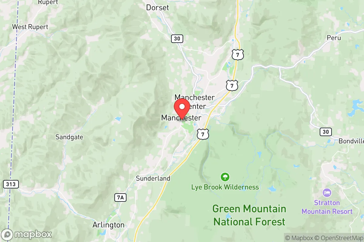
Regional Safe Places
Below is our recommended "safe zones" in Vermont and the surrounding area based on our strategic heuristics. For most people, it's unrealistic to live in a “safe zone” full-time due to work, family or other personal reasons. They tend to be more rural. However, many of these areas are perfect for second homes and retreat properties that double as a vacation home or even a short-term rental.


Important Note: For informational purposes only. This does not mean nothing bad ever happens in the green zones. Please use common sense. This is based on public data and modeled with AI. We tried to take a conservative approach but mistakes happen. We update this regularly as new information becomes available.
Solar Generator Recommendations
Backup power matters more here than in safer locations. We've picked three solar generators across budgets and capacity tiers — start with the budget unit if you only need a few essentials, or step up if you want to run a fridge and HVAC for days at a time.

Jackery Portable Power Station Explorer 300
Budget OptionPower on the Go: Weighing only 11 lbs, it's convenient to set up and store with book-sized foldable solar panels

BLUETTI Portable Power Station AC180
Designed for both indoor and outdoor scenarios, AC180 is highly capable as it has a robost capacity and continuous output power.

EF ECOFLOW DELTA Pro Ultra Power Station
Upgraded PickEcoFlow DELTA Pro Ultra is a whole-home energy system designed to grow with your family. Integrated with the Smart Home Panel 2, it scales to meet your evolving energy needs — keeping your home powered, intelligent, and secure through every stage of life.
We earn a commission, at no additional cost to you.
Strategic Assessment Analysis
Manchester, Vermont, offers a strategic paradox for the conservative prepper: it sits in a scenic, defensible valley of the Green Mountains, far enough from major population centers to avoid the immediate crush of a collapse event, yet close enough to the New York–Boston corridor to be a potential secondary fallout zone if those cities are targeted. Its year-round population hovers around 4,500, but that number swells with tourists, which complicates any long-term survival calculus. For a relocator prioritizing civic resilience, Manchester’s real value lies in its natural barriers, local food networks, and low-key infrastructure—but its proximity to high-value targets and seasonal population surges demand a sober, tactical assessment.
Geographic position and natural advantages for long-term security
Manchester sits in the Batten Kill Valley, flanked by the Green Mountain National Forest to the east and the Taconic Range to the west. This topography provides natural chokepoints: the only major routes in are VT-7A from the north and VT-11/30 from the east and south. In a grid-down scenario, these roads can be monitored or blocked with minimal effort, giving residents a significant defensive advantage. The surrounding national forest offers over 400,000 acres of public land for foraging, hunting, and timber, though it’s not private property—so you’ll need to secure your own acreage for true self-sufficiency. The area’s elevation (roughly 900 feet in town, rising to 3,000+ feet in the mountains) means cooler summers and harsh winters, which can be a double-edged sword: snow isolates you from threats but also from supply runs. The Batten Kill River runs through town, providing a reliable surface water source, though it’s not large enough for hydroelectric power without significant investment. The real advantage here is distance from major targets: Manchester is about 120 miles from Boston and 160 miles from New York City, placing it outside the immediate blast radius of a nuclear strike on those cities. However, prevailing winds from the southwest could carry fallout into the valley within hours, so a radiation plan is non-negotiable.
Risks, exposures, and proximity to fallout-relevant landmarks
The most glaring risk is Manchester’s location relative to the New York–Boston megalopolis. While 120–160 miles provides a buffer, it’s not enough to escape fallout from a high-yield ground burst. The Vermont Yankee nuclear plant in Vernon (about 60 miles south) was decommissioned in 2014, but spent fuel remains on-site in dry casks—a potential target for sabotage or a secondary disaster. The Albany, New York, metro area (about 70 miles southwest) is a plausible conventional or nuclear target, and its fallout plume could reach Manchester within 6–12 hours depending on weather. On the plus side, there are no major military bases, missile silos, or government continuity facilities within 50 miles, reducing the likelihood of a direct strike. The area’s biggest exposure is its reliance on tourism: the economy is built around ski resorts (Stratton, Bromley, Okemo) and the Manchester Designer Outlets. In a crisis, the seasonal population could double or triple, straining food, fuel, and medical resources. The local hospital, Southwestern Vermont Medical Center in Bennington (20 miles south), is a small critical-access facility with limited trauma capacity—a mass casualty event in the region would overwhelm it within hours. The state’s progressive politics also mean that Vermont’s government may impose restrictive measures during unrest (e.g., firearm confiscation orders, lockdowns), so you’ll need to plan for legal friction with state authorities.
Practical resilience for a relocator: food, water, energy, and defensibility
For a prepper, Manchester’s practical resilience is a mixed bag. Water is abundant: the Batten Kill and numerous springs in the national forest provide year-round supply, but you’ll need filtration (giardia is endemic) and a plan for winter freezing. The town’s municipal water comes from wells and a treatment plant, but that’s a single point of failure. Most homes in the area have private wells, which is a plus—but they require electricity to pump. Solar panels with battery storage are viable here (the region gets about 200 sunny days per year), but heavy snow can block panels for days. Wood heat is the default for many homes, and firewood is plentiful if you have land or access to national forest permits. Food resilience is decent: there are several small farms in the valley (e.g., Northshire Farm, Merck Forest) selling meat, eggs, and produce, but they’re not industrial-scale. The nearest major grocery is a Price Chopper in town, but it’s a single store—if supply chains break, it’s gone in 48 hours. Gardening is possible in the short growing season (May to September), but you’ll need cold frames or a greenhouse for year-round production. Defensibility is strong if you own property with a view of the approach roads; the valley’s narrow shape means you can see threats coming from a distance. However, the town itself is not defensible—it’s a tourist hub with multiple entry points and a police force of about 10 officers. Your best bet is a rural property on a dead-end road off VT-7A or VT-11, with a clear line of sight and a backup water source. The local gun culture is present but not overt; Vermont has some of the most permissive firearm laws in the country (constitutional carry, no magazine limits), but that could change under state pressure. Stock up on ammunition and consider a suppressor for noise discipline.
The overall strategic picture for Manchester is one of cautious viability for the prepared relocator. It’s not a hardened bunker location—it’s a scenic valley with real assets (water, wood, isolation) and real liabilities (tourist influx, single hospital, fallout risk from the Northeast corridor). If you’re looking for a place to ride out a short-term crisis (weeks to months), Manchester’s natural barriers and local food networks give you a fighting chance. For a long-term collapse scenario, you’d need to go deeper into the Green Mountains or northern New Hampshire. But for a conservative prepper who wants to stay within striking distance of family or business interests in the Northeast, Manchester offers a defensible base with enough resources to buy time—provided you’ve done the work on water, power, and security before the tourists arrive. The key takeaway: Manchester is a good location for a retreat, not a fortress, and only if you’re willing to accept the risks of being within fallout range of America’s most likely targets.
* Values derived from national, state, county, city and local statistics and may differ in a specific area. Last updated: 2026-04-30T10:46:40.000Z
Narrative content on this page is AI-generated and may contain mistakes. Verify any details that matter before acting on them.
ReloMaps may earn a commission from affiliate links at no extra cost to you.