
Photo: Wikipedia
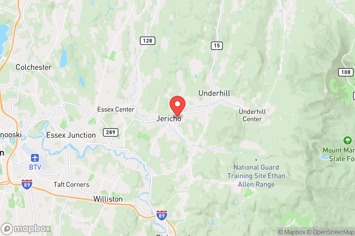
Strategic Assessment of Jericho, VT
Meaningful friction. Expect exposure to either population pressure, blast zones, or natural disaster risk. Consider buying a retreat property.
What does the Strategic Assessment tell us?
Our Strategic Assessment grades tactical survivability of an area. Major population centers, military targets, fallout zones, natural disasters, and border exposure all drive risk — lower exposure means a more defensible position in a crisis.
This is heavily inspired by Joel Skousen's Strategic Relocation book. Highly recommended you checkout the book ($)What does this tell us?
Our Strategic Assessment grades tactical survivability of an area. Major population centers, military targets, fallout zones, natural disasters, and border exposure all drive risk — lower exposure means a more defensible position in a crisis.
This is heavily inspired by Joel Skousen's Strategic Relocation book. Highly recommended you checkout the book ($)Strategic Pillars

Key Distances
Regional Safe Places
Below is our recommended "safe zones" in Vermont and the surrounding area based on our strategic heuristics. For most people, it's unrealistic to live in a “safe zone” full-time due to work, family or other personal reasons. They tend to be more rural. However, many of these areas are perfect for second homes and retreat properties that double as a vacation home or even a short-term rental.


Important Note: For informational purposes only. This does not mean nothing bad ever happens in the green zones. Please use common sense. This is based on public data and modeled with AI. We tried to take a conservative approach but mistakes happen. We update this regularly as new information becomes available.
Solar Generator Recommendations
Backup power matters more here than in safer locations. We've picked three solar generators across budgets and capacity tiers — start with the budget unit if you only need a few essentials, or step up if you want to run a fridge and HVAC for days at a time.

Jackery Portable Power Station Explorer 300
Budget OptionPower on the Go: Weighing only 11 lbs, it's convenient to set up and store with book-sized foldable solar panels

BLUETTI Portable Power Station AC180
Designed for both indoor and outdoor scenarios, AC180 is highly capable as it has a robost capacity and continuous output power.

EF ECOFLOW DELTA Pro Ultra Power Station
Upgraded PickEcoFlow DELTA Pro Ultra is a whole-home energy system designed to grow with your family. Integrated with the Smart Home Panel 2, it scales to meet your evolving energy needs — keeping your home powered, intelligent, and secure through every stage of life.
We earn a commission, at no additional cost to you.
Strategic Assessment Analysis
Jericho, Vermont, presents a compelling but nuanced case for the strategic relocator. Its small-town character and distance from major population centers offer a genuine buffer against the cascading failures of urban systems, yet its position in the Champlain Valley and proximity to Burlington introduce specific vulnerabilities that demand a clear-eyed assessment. For those prioritizing resilience over convenience, Jericho is a solid base camp, not a fortress—and understanding that distinction is the entire point of this analysis.
Geographic position and natural advantages for long-term stability
Jericho sits in a sweet spot that few New England towns can claim. It’s roughly 20 miles southeast of Burlington, Vermont’s largest city, but the Green Mountains and a network of state highways create a natural separation that discourages casual urban spillover. The town itself is nestled in the Brown’s River valley, with the Mount Mansfield State Forest and Underhill State Park forming a rugged eastern boundary. This terrain provides a meaningful defensive depth—any approach from the east requires navigating narrow, easily blocked roads through the mountains. The Lamoille River runs just north of town, and the Winooski River is a short drive south, offering redundant water sources that don’t depend on municipal infrastructure. The surrounding farmland is active, with several working dairies and vegetable operations within a 10-minute drive. For a relocator thinking in terms of decades, not election cycles, this combination of defensible geography and local food production is the foundation of a viable long-term position. The town’s elevation (roughly 700 feet) keeps it above the worst of the valley’s inversion layers, meaning air quality remains good even when regional conditions degrade.
Risks, exposures, and proximity to fallout-relevant landmarks
The most significant risk to Jericho is its proximity to Burlington and the associated infrastructure that makes it a target. Burlington International Airport is 25 miles southwest, and the city hosts the University of Vermont Medical Center, a major regional trauma center, as well as the Vermont Air National Guard base at the airport. In a scenario involving civil unrest or a mass casualty event, these are likely to become focal points for both official response and desperate movement. Jericho sits close enough to the I-89 corridor that refugees from Burlington or Winooski could filter eastward within hours. The town’s own population of roughly 5,000 would be quickly overwhelmed by even a modest influx. There are no hardened military installations or major government continuity sites in the immediate area, which is a double-edged sword: it reduces the chance of direct kinetic action, but also means no organized security response is likely to arrive quickly. The Vermont Yankee nuclear plant in Vernon is 120 miles south—outside the immediate fallout zone for most scenarios, but prevailing winds from the southwest could carry particulate into the Champlain Valley. A more immediate concern is the rail line running through nearby Essex Junction, which carries hazardous materials through the region. A derailment or intentional release could contaminate the Winooski River watershed, which feeds into Jericho’s groundwater.
Practical resilience for a relocator: food, water, energy, and defensibility
Jericho’s practical resilience is above average for a Vermont town of its size, but it requires active preparation. The municipal water system draws from wells and the Brown’s River, and while the town has backup generators for its pump stations, a prolonged grid failure would strain capacity. Every relocator should plan on a private well with a hand pump or a solar-powered backup—this is non-negotiable. The local food scene is strong: the Jericho Farmers’ Market runs June through October, and several CSAs operate within a 15-minute drive. For year-round food security, the town’s agricultural zoning allows for small-scale livestock and gardening without the bureaucratic hurdles found in more regulated towns. The energy picture is mixed. Green Mountain Power serves the area and has a decent reliability record, but the mountainous terrain makes tree-fall outages common in winter storms. Solar with battery storage is the most practical off-grid solution, and the state’s net metering policies make it financially viable even for those who stay grid-tied. Defensibility is where Jericho shines relative to its neighbors. The town’s layout is a classic New England village center with outlying farms and forest lots. The main roads—VT-15, VT-117, and Browns Trace—are easily monitored, and the numerous gravel roads and logging trails provide alternate egress routes for those who know the terrain. The local volunteer fire department is competent but small; in a crisis, residents will need to be self-sufficient for at least 72 hours, likely longer. The town’s emergency management plan is publicly available and worth reviewing, but it assumes state and federal support that may not materialize in a widespread event.
Overall strategic picture for the conservative relocator
Jericho is not a retreat in the bunker sense—it’s a working town with schools, a post office, and a general store that still sells ammo. That ordinariness is its strength. For a conservative relocator who wants to be part of a community rather than isolated from it, Jericho offers a realistic balance of access and buffer. The political climate in town leans left, but the surrounding towns of Underhill, Cambridge, and Fairfax have a more mixed electorate, and the local culture still values self-reliance and neighborly reciprocity over government dependency. The biggest strategic weakness is the lack of a deep, like-minded network. There are no organized preparedness groups or militia-style outfits in Jericho proper, and the state’s gun laws are among the most restrictive in the country—magazine capacity limits, a red flag law, and universal background checks are all on the books. If you plan to maintain a serious firearms capability, you will need to navigate Vermont’s legal landscape carefully and keep a low profile. The bottom line: Jericho is a viable long-term position for someone who wants to be within striking distance of Burlington’s resources (hospitals, hardware stores, fuel) but far enough away to have time to react when things go sideways. It’s not a bug-out location for the end of the world—it’s a place to build a life that can withstand the shocks of a declining empire. That’s a rare thing, and it’s worth a serious look.
* Values derived from national, state, county, city and local statistics and may differ in a specific area. Last updated: 2026-04-30T13:12:10.000Z
Narrative content on this page is AI-generated and may contain mistakes. Verify any details that matter before acting on them.
ReloMaps may earn a commission from affiliate links at no extra cost to you.