Photo: Wikipedia
Strategic Assessment of Canyon County
Workable tactical position. Some exposure to population density or targets, but generally defensible in a crisis.
What does the Strategic Assessment tell us?
Our Strategic Assessment grades tactical survivability of an area. Major population centers, military targets, fallout zones, natural disasters, and border exposure all drive risk — lower exposure means a more defensible position in a crisis.
This is heavily inspired by Joel Skousen's Strategic Relocation book. Highly recommended you checkout the book ($)What does this tell us?
Our Strategic Assessment grades tactical survivability of an area. Major population centers, military targets, fallout zones, natural disasters, and border exposure all drive risk — lower exposure means a more defensible position in a crisis.
This is heavily inspired by Joel Skousen's Strategic Relocation book. Highly recommended you checkout the book ($)Strategic Pillars

Key Distances
Strategic Assessment Analysis
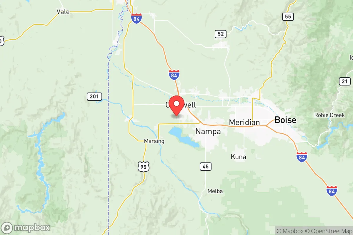
Canyon County, Idaho, offers a compelling strategic position for those prioritizing resilience, self-sufficiency, and distance from major metropolitan vulnerabilities. Located in the southwestern part of the state, the county benefits from being outside the immediate blast and fallout zones of high-value targets like Boise’s government and tech hubs, while still maintaining access to essential infrastructure. The area’s agricultural base, water resources, and relatively low population density make it a viable relocation option for conservative-minded individuals and families seeking a buffer from coastal instability and national-scale disruptions.
Geographic position and natural advantages for long-term survival
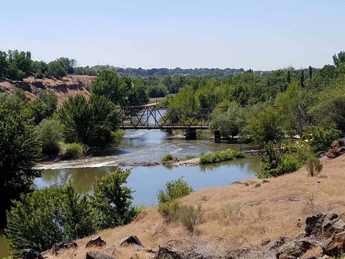
Canyon County sits in the Treasure Valley, a region defined by the Snake River and its tributaries, which provide a reliable water supply critical for sustained habitation. The county’s geography is a mix of irrigated farmland, rolling hills, and the Owyhee Mountains to the south, offering natural barriers and defensible terrain. Nampa, the county seat, and Caldwell are the primary population centers, but the surrounding rural areas—like Parma, Wilder, and Greenleaf—offer more isolated homesteading opportunities. The proximity to the Boise National Forest and the Payette National Forest provides additional resources for hunting, foraging, and timber, while the Snake River Plain offers fertile soil for agriculture. This combination of water, arable land, and natural cover is rare in the Intermountain West and gives Canyon County a distinct advantage over arid regions like southern Nevada or eastern Oregon.
Risks, exposures, and proximity to fallout-relevant landmarks
No location is without risk, and Canyon County’s strategic value is tempered by its proximity to certain vulnerabilities. The most significant concern is the Boise metropolitan area, roughly 20 miles east of Nampa, which houses the state capitol, the Idaho National Guard headquarters at Gowen Field, and major tech employers like Micron Technology. In a scenario involving nuclear or EMP attacks, Boise is a plausible secondary target due to its role as a regional government and economic hub. The fallout plume from a strike on Boise could drift into eastern Canyon County, particularly affecting Nampa and Caldwell. Additionally, the Union Pacific rail line running through the county is a potential chokepoint for logistics and a target for sabotage. The Snake River dams downstream, like the Swan Falls Dam, are critical infrastructure that, if compromised, could disrupt irrigation and power. However, the county’s distance from major military bases (e.g., Mountain Home Air Force Base is 40 miles southeast) and lack of heavy industry or refineries reduce its attractiveness as a primary target. The real risk is secondary fallout and refugee flow from Boise, which could overwhelm local resources if not planned for.
Practical resilience for a relocator: food, water, energy, and defensibility
For a relocator serious about self-reliance, Canyon County offers tangible advantages. Water access is the standout: the Snake River aquifer and numerous irrigation canals provide year-round surface water, and many rural properties have existing wells. The county’s agricultural output—including potatoes, sugar beets, and alfalfa—means local food production is robust, with farmers’ markets and co-ops in Nampa and Caldwell. For energy, the region is served by Idaho Power, which relies heavily on hydroelectricity from the Snake River, offering a more stable grid than coal-dependent regions. Solar potential is good, with over 200 sunny days per year, making off-grid setups feasible. Defensibility is mixed: the flat farmland of the Treasure Valley offers limited natural cover, but the Owyhee foothills to the south provide rugged terrain for retreat. The county’s population density is low enough (roughly 250,000 total) that rural properties can maintain significant standoff distance from neighbors. The Canyon County Sheriff’s Office has a reputation for proactive community policing, and the local gun culture is strong, with numerous shooting ranges and gun shops in Nampa. For medical resilience, the West Valley Medical Center in Caldwell and Saint Alphonsus Medical Center in Nampa provide emergency care, though major trauma cases would require transport to Boise. Stockpiling supplies and establishing a mutual-aid network with like-minded neighbors is advisable, as the county’s emergency services could be stretched during a regional crisis.
The overall strategic picture for Canyon County is one of balanced opportunity and calculated risk. It is not a remote bunker location—it sits within a day’s drive of Boise and the I-84 corridor, which connects to Oregon and Utah. But for those willing to invest in land, water rights, and community ties, it offers a viable middle ground between total isolation and urban vulnerability. The conservative political climate, with a strong ranching and farming heritage, aligns with the values of preparedness and local governance. The key is to secure property outside the immediate Boise fallout zone—ideally in the southern or western parts of the county, near the Owyhee border—and to develop relationships with local growers and tradespeople. Canyon County won’t shield you from every threat, but it provides the resources and space to weather many of them, making it a solid choice for a strategic relocation in an uncertain future.
* Values derived from national, state, county, city and local statistics and may differ in a specific area. Last updated: 2026-05-07T22:35:47.000Z
Narrative content on this page is AI-generated and may contain mistakes. Verify any details that matter before acting on them.
ReloMaps may earn a commission from affiliate links at no extra cost to you.