
Photo: Wikipedia
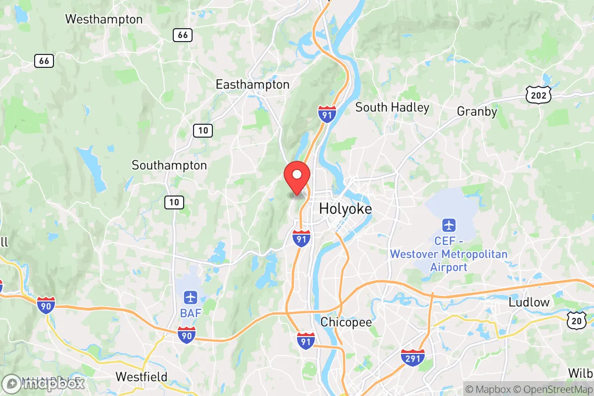
Strategic Assessment of Holyoke, MA
Multiple tactical vulnerabilities. Population density, target proximity, or disaster risk are likely compounding. A retreat property and exit planning is required.
What does the Strategic Assessment tell us?
Our Strategic Assessment grades tactical survivability of an area. Major population centers, military targets, fallout zones, natural disasters, and border exposure all drive risk — lower exposure means a more defensible position in a crisis.
This is heavily inspired by Joel Skousen's Strategic Relocation book. Highly recommended you checkout the book ($)What does this tell us?
Our Strategic Assessment grades tactical survivability of an area. Major population centers, military targets, fallout zones, natural disasters, and border exposure all drive risk — lower exposure means a more defensible position in a crisis.
This is heavily inspired by Joel Skousen's Strategic Relocation book. Highly recommended you checkout the book ($)Strategic Pillars

Key Distances
Regional Safe Places
Below is our recommended "safe zones" in Massachusetts and the surrounding area based on our strategic heuristics. For most people, it's unrealistic to live in a “safe zone” full-time due to work, family or other personal reasons. They tend to be more rural. However, many of these areas are perfect for second homes and retreat properties that double as a vacation home or even a short-term rental.


Important Note: For informational purposes only. This does not mean nothing bad ever happens in the green zones. Please use common sense. This is based on public data and modeled with AI. We tried to take a conservative approach but mistakes happen. We update this regularly as new information becomes available.
Solar Generator Recommendations
Backup power matters more here than in safer locations. We've picked three solar generators across budgets and capacity tiers — start with the budget unit if you only need a few essentials, or step up if you want to run a fridge and HVAC for days at a time.

Jackery Portable Power Station Explorer 300
Budget OptionPower on the Go: Weighing only 11 lbs, it's convenient to set up and store with book-sized foldable solar panels

BLUETTI Portable Power Station AC180
Designed for both indoor and outdoor scenarios, AC180 is highly capable as it has a robost capacity and continuous output power.

EF ECOFLOW DELTA Pro Ultra Power Station
Upgraded PickEcoFlow DELTA Pro Ultra is a whole-home energy system designed to grow with your family. Integrated with the Smart Home Panel 2, it scales to meet your evolving energy needs — keeping your home powered, intelligent, and secure through every stage of life.
We earn a commission, at no additional cost to you.
Strategic Assessment Analysis
Holyoke, Massachusetts, presents a mixed strategic picture for the conservative prepper or survivalist: it offers genuine geographic resilience and industrial water access, but sits uncomfortably close to major population centers and critical infrastructure that could become liabilities in a crisis. The city’s location in the Connecticut River Valley provides a natural defensive buffer of hills and farmland, yet its proximity to Springfield (just 8 miles south) and Boston (90 miles east) means that any large-scale civic unrest, mass casualty event, or grid-down scenario would likely send waves of displaced people northward. For a relocator weighing long-term security against everyday practicality, Holyoke is a location that demands careful mitigation—not a bug-out paradise, but a potential base if you understand its risks.
Geographic position and natural advantages for long-term security
Holyoke sits at the base of the Mount Tom Range, a series of traprock ridges that rise abruptly from the Connecticut River floodplain. This topography offers genuine defensive value: the hills to the west and north create natural chokepoints along major roads (Route 5, I-91), and the river itself forms a barrier that would slow movement from the south and east. The city’s elevation varies from about 100 feet along the river to over 800 feet in the nearby Mount Tom State Reservation, giving residents access to high ground for observation or retreat. The Connecticut River, which runs through Holyoke’s eastern edge, is a reliable water source—though it requires filtration and treatment. The region’s agricultural history is still visible: the surrounding Pioneer Valley contains some of the most productive farmland in New England, with soil that could support small-scale food production. For a relocator, this means you’re not entirely dependent on supply chains; you could theoretically grow food, harvest timber, and access wild game (deer, turkey, small game) within a short drive. The climate is temperate, with four distinct seasons, but winters are cold enough to require serious heating prep—wood stoves and passive solar are viable, but fuel storage becomes a concern.
Risks, exposures, and proximity to fallout-relevant landmarks
The biggest strategic liability is Holyoke’s position relative to high-value targets. Springfield, with its federal buildings, rail yards, and the Springfield Armory National Historic Site (a symbolic target), is only 15 minutes south. The I-91 corridor runs directly through Holyoke, connecting it to Hartford (40 miles south) and the New York metro area (150 miles). In a mass casualty event or civil unrest scenario, this highway becomes a funnel for refugees and looters. Holyoke itself has a population of about 38,000, but the greater Springfield metro area holds nearly 700,000 people—meaning any collapse in that urban core would spill northward. Additionally, the city is within 50 miles of the Vermont Yankee nuclear site (decommissioned but still storing spent fuel) and within 100 miles of the Seabrook Station nuclear plant in New Hampshire. A radiological release from either would put Holyoke in a downwind risk zone depending on prevailing winds. There are no major military bases nearby, but Westover Air Reserve Base in Chicopee (10 miles south) is a strategic airlift hub that could become a target or a rallying point during conflict. Flooding is a real concern: the Connecticut River has a history of spring floods, and Holyoke’s low-lying areas near the river and canals are vulnerable. The city’s aging infrastructure—including the Holyoke Dam and canal system—could fail during a prolonged grid-down event, cutting off water and power to large sections.
Practical resilience for a relocator: food, water, energy, and defensibility
Holyoke’s water supply is a double-edged sword. The city draws from the Connecticut River and the Quabbin Reservoir (via the Chicopee River system), but treatment plants rely on grid power. A prepper would need a backup plan: rainwater catchment, well access (limited in urban areas), or portable filtration systems. The Holyoke Dam, which generates hydroelectric power, could be a local asset if the grid fails—but it’s also a single point of failure. In a long-term outage, the dam would likely be secured by authorities, not open to civilians. Food security is better than in most cities: the Pioneer Valley has dozens of farms, farmers’ markets, and CSAs within a 20-minute drive. You could stockpile from local sources without relying on trucked-in supplies. However, Holyoke itself is a food desert in parts—the downtown area has limited grocery options, and many residents depend on convenience stores. For a relocator, buying property on the outskirts (near the Mount Tom range or in neighboring Easthampton) gives better access to farmland and defensible terrain. Defensibility is moderate: the city’s grid layout and dense housing stock make it hard to secure a perimeter, but the hills to the west offer retreat options. The local population is diverse and economically mixed, with a significant Puerto Rican community and a history of industrial decline. In a crisis, social cohesion could be weak—there’s no strong prepper or militia culture here. You’d likely be on your own, which is both a risk and an advantage: less competition for resources, but also less mutual aid.
The overall strategic picture for Holyoke is one of calculated trade-offs. It’s not a remote bunker location, but it offers genuine natural advantages—water, farmland, defensible terrain—that many New England cities lack. The proximity to Springfield and the I-91 corridor is a serious liability in a collapse scenario, but for a relocator who can secure property on the high ground west of the river and build a self-sufficient homestead with solar, well water, and food storage, Holyoke could serve as a viable base for weathering short-to-medium-term disruptions. The key is to treat it as a staging area, not a final retreat: have a bug-out plan for the hills or northern Vermont if things go truly sideways. For the conservative prepper who wants to stay within striking distance of New England’s economic hubs while maintaining a credible survival posture, Holyoke is worth a hard look—but only with eyes wide open to its vulnerabilities.
* Values derived from national, state, county, city and local statistics and may differ in a specific area. Last updated: 2026-05-01T09:07:15.000Z
Narrative content on this page is AI-generated and may contain mistakes. Verify any details that matter before acting on them.
ReloMaps may earn a commission from affiliate links at no extra cost to you.